


Anthurium parvispathum Hemsl.,
Biol. Cent. Amer., Bot. 3: 432. 1885. TYPE: Guatemala. Baja Verapaz: Santa Rosa, Salvin & Godman 408 (K, holotype).
Anthurium hypoleucum Standl., J. Wash. Acad. Sci. 17: 246. 1927.
Anthurium brevipeliolatum Engl. ex K. Krause, Notizbl. Bot. Garl. Berlin-Dahlem 11:610. 1932. TYPE: Guatemala. Baja Verapaz:Santa Rosa, 1,600 m, Tuerckheim 11.2214 (US-932125, holotype; B, isotype).
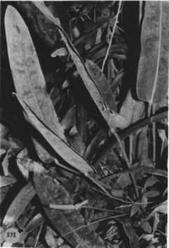
Epipetric; stem short; roots thick, tan, sometimes directed upward;
cataphylls ca. 7 cm long, drying brown, persistent, weathering to coarse
linear fibers.
LEAVES spreading; petioles 16-50 cm long, 6-9 mm diam., broadly and sharply sulcate, weakly glaucous; gcniculum 1.3-1.5 cm long; blades oblong to lanceolate, subcoriaceous, acute at apex, truncate at base, 27-64 cm long, 6.5-12 cm wide; both surfaces matte and glaucous, the lower surface only slightly paler; midrib convexly raised above, diminished and sunken at apex, more acutely raised below; basal veins one pair, sunken above, raised below; primary lateral veins 6-10 per side, departing midrib at 40° angle, sunken above, raised below; interpri-mary veins weakly sunken above, flat below; lesser veins obscure; collective vein arising from the basal vein, 8-10 mm from margin, sunken above, raised below.
INFLORESCENCE spreading, shorter to as long as leaves; peduncle
31-52 cm long, subterete, 1-2 faint ribs; spathe subcoriaceous, green (B
& K Green 5/7.5), lanceolate, 3.5-7 cm long, 1-2 cm wide, long-acuminate
at apex, clasping at base, inserted at 180° angle on peduncle; spadix
sessile, green (B & K
Yellow-green 7/7.5) becoming pale yellow, 3.5-9 cm long, 7-10 mm diam.
at base, 3-5 mm diam. at apex; flowers 4-lobed, ca. 2.3 mm in both directions,
the sides jaggedly sigmoid; 5-7 flowers visible in the principal spiral,
7-9 flowers visible in the alternate spiral; lepals matte, lateral tepals
ca. 1 mm wide, the inner margin convex; pistils green, weakly emergent;
stigma slit-like; stamens emerging from the base, laterals emerging first,
followed quickly by alternates, the leading stamen preceding fourth stamen
by 1-3 spirals.
INFRUCTESCENCE pendent, mature berries not seen. Fig. 131.
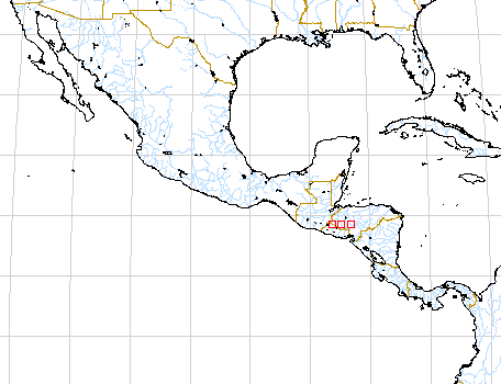
Anthurium parvispathum is endemic to Guatemala and is known principally
from Baja Verapaz at 1,500 to 1,800 m elevation, but it is also known from
single collections from the Sierra de la Minas in Zacapa Department and
at Mazatenango in the Dept. of Suchitepequez on the Pacific Coast. The
species occurs principally in open or exposed areas on rocks in areas of
dry forest.
The species is a member of section Belolonchium and is
characterized by having a sessile spadix and oblong-lanceolate leaves that
are at least initially glaucous (often drying whitish) on the lower surface
and by having the primary lateral veins equally as prominent as the basal
vein. The species is also characterized by occurring on rocks.
Anthurium parvispathum is similar to A.
nakamurae from southeast Chiapas but differs in having thicker
leaves, which are generally much paler and weakly glaucous on the lower
surface. In addition, it is always found growing on rocks rather than as
an epiphyte. The spadix of A. parvispathum is always sessile whereas
that of A. nakamurae is stipitatc at least to some extent.
Anthurium parvispathum has also been confused with A.
retiferum, which has a similar leaf shape and venation, but that
species has much broader leaves that have conspicuously elevated tertiary
veins on drying and is not glaucous or pale on the lower surface. It has
also been confused with some leaf forms of A.
subcordatum, but that species differs in having the basal veins
much more conspicuous than the primary lateral veins.
 |
Map of Mesoamerican specimens with coordinates
Guatemala Alta Verapaz: 2150 m,, 20 Mar 1989, Forther s.n. (M).
Guatemala Baja Verapaz: Mun. San Jeronimo, 1030 m,, 24 July 1988, Tenorio
et al. 14804 (MO).
Guatemala Baja Verapaz: 1600 m,, , Tuerckheim 2214 (B).
Honduras Comayagua: Cordillera de Montecillos, 1900-2000 m, 14.29N
87.53W, 10 May 1991, Davidse 34284 (MO).
Honduras Lempira: Montaña de Celaque, 1800-1900 m, 14.33N 88.39W,
24 May 1991, Davidse & Zuniga 34658 (MO).
Honduras Lempira: Montaña de Celaque, 2300-2400 m, 14.33N 88.40W,
25 May 1991, Davidse & Zuniga 34743 (MO).
Honduras Lempira: Montaña de Celaque, 1290-1400 m, 14.33N 88.39W,
23 May 1991, Davidse & Zuniga 34557 (K, MO).
Honduras Lempira: Celaque National Park, 2400 m, 14.33N 88.41W, 18
Nov 1991, Robbin C. Moran 5641 (MO).
Honduras Lempira: 1400-1500 m, 14.33N 88.38W, 10 May 1992, W.G. D'Arcy
17858 (MO).
Honduras Ocotepeque: 1800 m, 14.28N 89.15W, 28 Jan. 1987, Thomas B.
Croat & Dylan P. Hannon 63813 (MO).
Mexico Chiapas: Mpo. Ocozocoautla, 1080 m,, 25 Apr. 1988, Breedlove
66993 (CAS).
Mexico Chiapas: 600 m,, 26 Sept. 1988, Breedlove 70157 (CAS).
Mexico Chiapas: Mpo. Berriozábal, 830 m,, 23 Aug. 1981, Breedlove
52375 (CAS).