


Anthurium pentaphyllum (Aubl.) G. Don in Sweet, Hortus Brit., 3rd ed., 633. 1839.
Anthurium pentaphyllum var. bombacifolium
(Schott) Madison, Sclbyana 2: 278. 1978. Anthurium bombacifolium Schott, Oesterr. Bot.Z.8: 182. 18 5 8. TYPE: Costa Rica. Near Atenas, Hoffmann 779 (B, type destroyed; Photo of Schott Aroid Drawing #829, NYBG Neg. #N.S.3934).
Anthurium aemulum Schott, Bonplandia 7: 165. 1859. TYPE: Mexico. Colipa, Liebmann 15799 (C?, not seen; Photo, D. Nicolson, 2 June 1963-13).Epiphytic; stems creeping up tree trunks; cataphylls caducous or persisting as coarse fibers; petioles 19-44 cm long, ca. 5 mm diam., terete; blades digitately compound with 5-11 leaflets, moderately thin, leaflets oblanceolate to narrowly elliptic, 13-30 cm long, 2.5-9 cm wide, the median leaflet equilateral, the lateral leaflets inequilateral, cuneate-attenuate at base. Inflorescence erect; peduncle 1-6 cm long; spathe pale green to purple, lanceolate to ovate, moderately thick, 6-10 cm long, 1-2.8 cm wide, early de-ciduous; spadix pale violet purple, 2.2-10(-15) cm long, 8-20 mm diam. at base; berries red to dark red-violet, more or less ellipsoid, 5-8 mm diam. See Croat (1983: 348) for a more complete description.
Anthurium karwinskyi Schott, Oesterr. Bot. Z. 9: 101. 1859. TYPE: Mexico. Veracruz: Colipa, Karwinsky s.n. (LE).
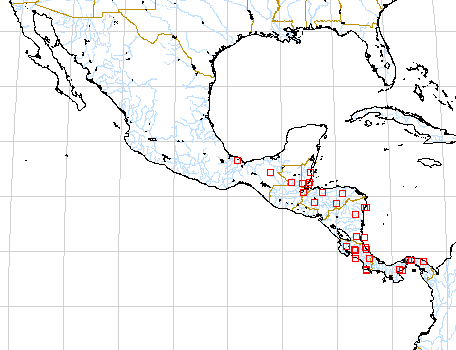
Anthurium pentaphyllum var. bombacifolium is known from Mexico to Panama at elevations from near sea level to 800 m, occurring principally on the Atlantic slope in Mexico and Middle America but on both slopes in Costa Rica and Panama. The species occurs in premontane moist, tropical moist, premontane wet, and tropical wet forest life zones making it one of the most eco-logically variable species of Anthurium in Central America.
The species is a member of section Dactylophyllium and is most easily confused with Anthurium kunthii, which has similar leaves. Anthurium kunthii differs, however, in having a longer peduncle, three-fourths the length of the petiole, a long, slender, greenish spadix, and lateral leaflets that are more or less equilateral at the base.
Map of Mesoamerican specimens with coordinates
Belize Belize: 20 m, 17.34N 88.32W, 4 Feb. 1987, Jonathan Lyon
5 (MO).
Belize Cayo:, 16 April 1955, Gentle 8674 (LL).
Belize Cayo: Chiquibul National Park, 550 m, 15.45N 89.07W, 15 Oct.
1993, Ingram & Ferrell-Ingram 1904 (MO).
Belize Cayo: 200 m,, 6 Oct 1994, D.J. Murray 6 . Belize Toledo: Río
Grande,, 30 November 1944, Gentle 5009 (LL).
Belize Toledo:, 16 December 1945, Gentle 5464 (LL). Belize Toledo:,
16 December 1945, Gentle 5465 (LL).
Belize Toledo:, 20 Aug 1950, Gentle 7111 (LL). Belize Toledo:, 26 Apr
1950, Gentle 7041 (LL).
Belize Toledo:, 15 Aug 1950, Gentle 7107 (LL). Belize Toledo:, 22 Oct
1952, Gentle 7804 (LL).
Belize Toledo:, 7 March 1952, Gentle 7584 (LL). Belize Toledo:, 7 March
1952, Gentle 7588 (LL).
Belize Toledo: 700-750 m, 16.23N 89.09W, 6 April 1992, Bruce K. Holst
4116 (MO).
Belize Toledo: 100-250 m, 16.33N 88.47W, 2-3, 11 Mar 1987, Gerrit Davidse
& Alan E. Brant 31940 (MO).
Belize Toledo: 100-200 m, 16.32N 88.47W, 9, 11, 12 Mar 1987, Gerrit
Davidse & Alan E. Brant 32231 (MO).
Belize Toledo: 20 m, 16.16N 88.52W, 6 May 1996, Bruce K. Holst, G.
Davidse & A. Whittemore 5130 (BRH, CM, MO, SEL).
Costa Rica : 840 m, 10.20N 84.40W, 24 Jul 1986, William A. Haber
ex E. Bello C. & April Clagget 5431 (MO).
Costa Rica Alajuela: 800-1000 m,, 26 enero 1987, G. Herrera Ch., V.
Mora, Abelardo e Isidro Chacón y A. Solis 415 (MO).
Costa Rica Alajuela:, 29 junio 1985, William A. Haber & Eric Bello
C. 1694 (MO).
Costa Rica Alajuela: 1100 m, 10.10N 84.29W, 25 April 1983, Ronald Liesner
& Emmet Judziewicz 14941 (MO).
Costa Rica Guanacaste: 850-940 m, 10.46.30N 85.18.00W, 25 Jan 1986,
Michael H. Grayum, Alan R. Smith & Tania Béliz 6240 (MO).
Costa Rica Heredia:, 2 Feb 1983, Garwood et al. 847 (BM).
Costa Rica Heredia: 70-100 m, 10.27N 84.04W, 2 June 1985, Michael H.
Grayum & Brian Jacobs 5330 (MO).
Costa Rica Heredia: 700-950 m, 10.17.30N 84.04.30W, 9 April 1986, Michael
H. Grayum 6932 (MO).
Costa Rica Heredia: Finca La Selva, 100 m,, , Jacobs 2658 (DUKE).
Costa Rica Limn: 20-170 m, 10.41N 83.38W, 16-23 Jan 1986, Warren Douglas
Stevens 23904 (MO).
Costa Rica Limn: 10-40 m, 10.40N 83.40W, 13-14 Sep 1986, Warren Douglas
Stevens 24260 (MO).
Costa Rica Limn: 150 m, 09.39N 83.02W, 1 August 1985, Michael H. Grayum,
B. Hammel, L. Bermúdez & R. Acosta 5811 (MO).
Costa Rica Limn: 10-80 m, 10.40.30N 8.39.30W, 17-18 Sep 1986, Gerrit
Davidse & Gerardo Herrera 31335 (MO).
Costa Rica Limn: 10-80 m, 10.40.30N 8.39.30W, 17-18 Sep 1986, Gerrit
Davidse & Gerardo Herrera 31397 (MO).
Costa Rica Limn: 40 m, 10.25N 83.34W, 4 November 1987, Rafael Robles
1220 (MO).
Costa Rica Limn: 40 m, 10.25N 83.34W, 4 November 1987, Rafael Robles
1230 (MO).
Costa Rica Puntarenas: 40 m, 08.41N 83.32W, 8 Oct 1984, Michael Grayum
4113 (MO).
Costa Rica Puntarenas: 100 m,, , Gomez 19483 (K). Costa Rica Puntarenas:
50 m, 8.28N 83.35W, 30 April 1989, C. Kernan 1059 (MO).
Costa Rica San José: 500-600 m, 09.45.30N 84.33.00W, 7 August 1985,
Michael H. Grayum, R. Warner, J. C. French & P. Sleeper 5849 (MO).
Costa Rica San José: 600-700 m, 10.09.50N 83.57.10W, 30 August 1996,
Thomas B. Croat 78762 (MO).
Guatemala Alta Verapaz:, 16 Apr. 1964, Contreras 4346 (LL).
Guatemala Alta Verapaz:, 3 May 1964, Contreras 4620 (LL).
Guatemala Peten: Tikal National Park,, 30 April 1959, Lundell 15941
(LL).
Guatemala Peten: Tikal National Park,, 9 February 1959, Lundell 15436
(LL).
Guatemala Peten: Tikal National Park,, 30 March 1960, Lundell 16667
(LL).
Guatemala Peten: Tikal National Park,, 28 February 1961, Lundell 16805
(LL).
Guatemala Peten:, 14 July 1959, Lundell 16471 (LL).
Guatemala Peten: Tikal National Park,, 2 February 1959, Lundell 15277
(LL).
Guatemala Peten: Tikal National Park,, 31 January 1959, Lundell 15269
(LL).
Guatemala Peten: Río Mopan,, 6 May 1961, Contreras 2265 (LL).
Guatemala Peten: Puerto Chimono, 110 m, 16.34N 90.14W, 13 June 1990,
Zomer 293 (U).
Guatemala Peten:, 13 May 1966, Contreras 5756 (LL).
Honduras Atlántida: 70-90 m, 15.44N 87.27W, 9 Feb. 1987,
Thomas B. Croat & Dylan P. Hannon 64645 (MO).
Honduras Comayagua: 610 m, 14.47N 88.00W, 11 May 1991, Davidse 34342
(MO).
Honduras Comayagua:, , Zuniga 639 (UNAH).
Honduras Copán: Nueva Arcadia, 560 m.,, 14 jul 1971, Harmon,
W. E. & J. A. Fuentes 6421 (UMO 100207).
Honduras Honduras:, , Lancetilla 10514 (UNAH).
Honduras Olancho: 400 m, 14.45N 86.00W, 4 Feb. 1987, Thomas B. Croat
& Dylan P. Hannon 64128 (MO).
Honduras Olancho: 350-400 m, 15.31N 85.42W, 8 Feb. 1987, Thomas B.
Croat & Dylan P. Hannon 64517 (MO).
Mexico :, 14 July 1947, Matuda 17794 (MO).
Mexico Chiapas: Mpo. Ococingo,, 27 Sept. 1984, Martínez 7925 (MEXU,
MO).
Mexico Chiapas: Mpo. Ocosingo, 1200 m,, 2 Aug. 1984, Martínez et al.
111A (MO).
Mexico Chiapas: Mpo. Ococingo, 130 m,, 12 Jan. 1986, Martínez 16141
(MO).
Mexico Chiapas: 450 m, 17.29N 92.05W, 10 Oct 1986, B. Hammel, E. Martínez
& M. Merello 15636 (MO).
Mexico Tabasco: Mpo. Tacotalpa,, , Cowan et al. 3497 (CSAT).
Mexico Tabasco: Mpo. Tacotalpa,, , Cowan 2723 (CAS, CSAT). Mexico Tabasco:,
4 July 1981, Cowan & Niño 3384 (CAS).
Mexico Veracruz: 150-200 m, 18.42N 95.10W, 17 Jan. 1987, Thomas B.
Croat & Dylan P. Hannon 63159 (MO).
Nicaragua Zelaya: Cerro Baka, 200-320 m, 13.40N 84.30W, 19 Mar.
1979, Pipoly, J. 4920 (MO).
Nicaragua Zelaya: Colnia Yolaina, 300 m, 11.38N 84.21W, 13 Aug. 1982,
Araquistain, M. 3097 (MO).
Nicaragua Zelaya: 10 m, 11.36N 83.51W, 06 Feb. 1982, Moreno, P. and
Sandino, J. 14897 (MO).
Nicaragua Zelaya: 5-10 m, 11.36N 83.39W, 21 octubre 1981, P.P.Moreno
y J.C.Sandino 12016 (MO).
Nicaragua Zelaya: 80-100 m, 11.35N 84.22W, 28 julio 1982, Juan C. Sandino
3293 (MO).
Nicaragua Zelaya: 10 m, 14.06N 83.40W, 2 May 1978, W.D. Stevens 8646
.
Nicaragua Zelaya: 5-10 m, 14.09N 83.29W 14.11N 83.31W, 6 October 1978,
W.D. Stevens 10658B .
Nicaragua Zelaya: 200-300 m, 11.36-37N 84.22W, 29-31 October 1977,
W.D. Stevens 4820 (MO). Nicaragua Zelaya: 150-180 m, 11.43N 84.18W, 6-7
November 1977, W.D. Stevens 5057 (MO).
Nicaragua Zelaya: 180-200 m, 11.40N 84.26W, 11-12 February 1978, W.D.
Stevens 6353 (MO).
Panama Cocl: 200-400 m, 8.45N 80.35W, 4 Feb. 1983, C. Hamilton
& G. Davidse 2789 (MO).
Panama Cocl: 775 m, 08.36N 80.07W, 25 March 1993, Thomas B. Croat
74784 (MO).
Panama Coln: 200 m, 9.20N 79.47W, 29 June 1984, H.W. Churchill 5556
(MO).
Panama Coln: c. 250 m, 09.21N 79.44W, 17 July 1994, Thomas B. Croat
& Guanghua Zhu 76978 (MO).
Panama San Blas: 3-30 m, 9.24N 79.24W, 26 March 1986, Greg de Nevers,
H. Herrera & S. Charnley 7408 (MO).
Panama San Blas: 50 m, 9.24N 79.24W, 16 Dec. 1985, Greg de Nevers,
H. Herrera & S. Charnley 6538 (MO).
Panama San Blas: 20-30 m, 09.16.5N 78.15W, 14 Julio 1994, Heraclio
Herrera 1694 (MO,PMA,STRI).