


Anthurium louisii Croat & Baker,
Brenesia 16 (Supl. I): 59. 1979. TYPE: Costa Rica. Cartago: about 2.5
km north by east northeast of Tapanti, 9°45'N, 83°47'W, 1,500-1,600
m elevation; forest remnants on steep slopes, Baker. Utiey & Ulley
220 (F-1758200, ho-lolype; MO-2385464, isotype.
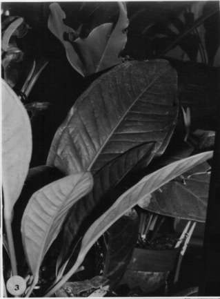
Epiphyte or terrestrial, to 30 cm tall; stems erect, to 1 cm diam.;
inlcmodes 1-4 cm long; leaf scars obscured by calaphyll fibers; cataphylls
4-7 cm long, gradually acuminate at apex, drying brown, quickly weathering
into coarse persistent fibers.
LEAVES dispersed along stem at each node; petioles (15)20-30
cm long, ca. 3 mm diam., terete, narrowly sulcate; geniculum ca. 1.5 cm
long; blades ovate to broadly ovate, subcoria-ccous, gradually to abruptly
long-acuminate at apex, obtuse or truncate to rounded at base, 14-17 cm
long, 8-13.5 cm wide, broadest slightly below the middle; both surfaces
conspicuously glandular-punctate; midrib raised above, diminished toward
apex, prominently raised below; primary lateral veins 15-20 per side, departing
midrib at 45° angle, = straight, loop-connected by the collective vein,
raised above and below; lesser veins inconspicuous; collective vein arising
from the base, 4-12 mm from the margin.
INFLORESCENCE, erect-spreading; peduncle (1 5)25-38(45) cm long,
considerably longer than the leaves; spathe somewhat thin, green becoming
reddish, lanceolate-linear, 4-6.5 cm long, ca. 1 cm wide, broadest at base,
gradually acuminate at apex, slightly clasping at base, inserted at ca.
20° angle on peduncle; stipe very short or absent; spadix green to
yellow-green, usually coiled at maturity, (4)6-18 cm long, 3-4 mm diam.
at base, 2-3 mm diam. at apex (dry); flowers rhombic, 2-3.5 mm long, 2-2.5
mm wide; the sides ± straight; 2-3 flowers visible in either spiral;
lateral tepals 1.6-2.1 mm wide, the inner margin broadly rounded; pistil
green; stigma ca. 0.5 mm long, ellipsoid; stamens probably weakly exsert-ed
above the tepals, well spaced; filaments ca. 0.2 mm long; anthers ovate,
0.4-0.5 mm long, 0.5-0.6 mm wide; thecae ellipsoid, slightly divaricate.
INFRUITESCENCE with the spathe at least sometimes deciduous;
spadix 8-15 cm long, 3-4 mm diam., usually coiled in age; berries ovoid
to subglobose, green becoming orange-red, ca. 6 mm long and 5 mm wide,
maturing simultaneously throughout the spadix, drying with a bullonlikc
beak. Fig. 103.
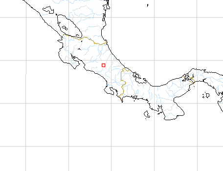
Anthurium louisii is known only from Costa Rica in premontane
or lower montane rain forest, apparently restricted to middle elevations
on the Atlantic slopes of the Cordillera Central and the Cordillera dc
Talamanca, 1,300 to 1,800 m.The species is in section Porphyrochitonium
and can be recognized by its broadly ovate leaves with glandular punctations
on both surfaces and by its usually coiled spadix (in fruit). The type
collection was found on a steep bank and formed the dominant ground cover.
Anthurium louisii is related to A. angusturense Engl. from
Colombia. The latter species differs chiefly by its lanceolate leaf blades.
Anthurium louisii also resembles A. circinatum Croat from
Panama in Chiriquí Province.
Map of Mesoamerican specimens with coordinates
Costa Rica Cartago: 1400 m, 09.47N 83.47W, 10 Aug 1984, Michael H. Grayum
& Brian Jacobs 3718 (MO).
Costa Rica Cartago: 1700-1840 m, 09.43.00N 83.46.30W, 9 Oct 1986, Michael
H. Grayum & Gerardo Herrera 7743 (MO).
Costa Rica Cartago: Tapantí Hydroelectric Project, 1300-1600
m,, , Utley & Utley 4532 (DUKE).
Costa Rica Cartago: 1300-1500 m,, , Utley & Utley 5035 (DUKE).
Costa Rica Cartago: 1500 m, 09.46.30N 083.32.40W, 26 July 1995, G.
Herrera & A.Cascante 8125 (CR, MO).
Costa Rica Limn: P.N. Cordillera de Talamanca; Cordillera de Talamanca,
1500 m, 09.21.23N 83.13.40W, 19 March 1993, Alvaro Fernandez 731 (CR, MO).
Costa Rica Limn: P.N. Cordillera de Talamanca; Cordillera de Talamanca,
1700 m, 09.23.20N 83.12.20W, 28 March 1993, Alvaro Fernandez 862 (CR).
Costa Rica Limn: P.N. Cordillera de Talamanca; Cordillera de Talamanca,
1700 m, 09.23.10N 83.06.35W, 13 March 1992, Gerardo Herrera 5342 (CR, MO).
Costa Rica Limn: P.N. Cordillera de Talamanca; Cordillera de Talamanca,
1750 m, 09.23.20N 83.06.00W, 22 March 1992, Gerardo Herrera 5435 (CR, MO).
Costa Rica Limn: P.N. Cordillera de Talamanca; Cordillera de Talamanca,
1900 m, 09.22.45N 83.06.15W, 25 March 1992, Gerardo Herrera 5509 (CR).
Costa Rica San José: 1900 m,, 12 Mar 1984, G. Davidse, L.D. Gómez,
G. Herrera, C.R. Chacón, I. & A. Chacón 25587A (MO).