


Anthurium paludosum is known from Costa Rica to Colombia at elevations from sea level to 400 m. West of the Isthmus of Panama it ranges along the Atlantic slope only. To the east of the Isthmus of Panama it occurs on both slopes until reaching South America where it is restricted to the Pacific slope. The species occurs in wetter parts of tropical moist forest and premontane wet and tropical wet forest life zones. Anthurium paludosum is a member of section Porphyrochitonium and is recognized by its coriaceous, almost oblong leaf blades that are more or less the same color on both sides with a pale green midrib on the upper surface, its thick, persisting intact cataphylls, and by its reddish orange berries. No other species in this section is known to have cataphylls that remain intact.
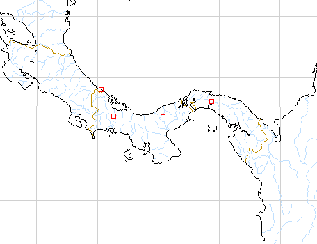
Map of Mesoamerican specimens with coordinates
Costa Rica Limn: 1-10 m, 09.38N 82.39W, 4 Nov 1984, Michael Grayum,
Willie Burton & Ernesto Salazar 4366 (MO).
Costa Rica Limn: 0 m, 09.35N 82.36W, 29 January 1987, Michael Grayum,
Bill McLarney & Fred Field 8039 (MO).
Costa Rica Limn: 280 m, 9.29.50N 82.59.10W, 4 July 1989, Gerardo Herrera
3134 (MO).
Panama :, , Kamemoto 309-1 (AAU, CAS, NY, OOM, US).
Panama Bocas del Toro: 590 m, 8.46N 82.14W, 10 March 1985, T.B. Croat
& M.H. Grayum 60198 (MO).
Panama Canal Area:, 8 Mar. 1971, Thomas B. Croat 13989 (MO).
Panama Chiriquí: 80 m, 8.50N 82.10W, 9 March 1985, T.B. Croat &
M.H. Grayum 60089 (MO).
Panama Cocl: 200-400 m, 8.45N 80.35W, 4 Feb. 1983, C. Hamilton &
G. Davidse 2706 (MO).
Panama Cocl: 700 m, 8.47N 80.28W, 11 Dec. 1983, H.W. Churchill, A.
Lier, W.S. Armbruster & A. Herzig 4075 (MO).
Panama Panamá: 200-250 m, 9.15.00N 78.59.00W, 30 Mar 1988, Thompson
4643 (CM).
Panama San Blas: 300-350 m, 9.15N 79.00W, 12 July 1988, Thomas B. Croat
69285 (MO).
Panama San Blas: 300-350 m, 09.15N 79.00W, 27 March 1987, Gordon McPherson
10763 (MO).
Panama San Blas: 50-150 m, 9.24N 79.08W, 27 Jan 1985, Greg de Nevers
4685 (MO).
Panama San Blas: 350 m, 9.19N 78.55W, 20 Nov. 1984, Greg de Nevers
& H. Herrera 4357 (MO).
Panama San Blas: 350 m, 9.19N 78.55W, 2 Nov. 1985, Greg de Nevers,
H. Herrera & S. Charnley 6135 (MO).
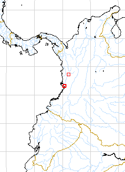
Map of South American Specimens with coordinates
Colombia Choco: 100 m, 5.14N 76.40W, 15 April 1983, Thomas B. Croat
55974 (JAUM, MO).
Colombia Choco: 70 m,, 8 Sept 1976, Forero & Jaramillo 2692 (COL,
MO).
Colombia Choco: Río Baudó Región,, 2 Feb-29 Mar
1967, Fuchs et al. 21869 (COL, US).
Colombia Choco: Río Baudó Región,, 2 Feb-29 Mar
1967, Fuchs et al. 22083 (COL,US).
Colombia Valle del Cauca: 150 m, 04.02N 77.04W, 17 July 1993, Thomas
B. Croat & Dorothy Bay 75804 (MO).
Colombia Valle del Cauca: Bajo Calima, 50-80 m, 3.56.00N 77.7.30W,
19 July 1988, Thomas B. Croat 69412 (MO).
Colombia Valle del Cauca: Bajo Calima, 40.03N 77.08W, 5 February 1990,
Thomas B. Croat & Jonathan Watt 70234 (MO).
Colombia Valle del Cauca: near sea level,, 2 June 1944, Killip &
Cuatrecasas 38646 (COL).
Colombia Valle del Cauca: 150 m,, , Maas & Plowman 1950 (GH).
Colombia Valle del Cauca: Bajo Calima, 50 m, 03.56N 77.08W, 16 Feb
1983, Al,Gentry, A. Juncosa, H. Mazuera & W. Ladrach 40406 (COL, MO).
Colombia Valle del Cauca: 5 m,, 05 febrero 1990, W. Devia A., R. Bernal
y E. Linares 2943 .
Colombia Valle del Cauca: Río Dagua, 40 m,, 15 Feb. 1939, Killip &
Garcia 33334 (COL).