


Anthurium tilaranense Slandl., J. Wash.
Acad. Sci. 17: 245. 1927. TYPE: Costa Rica. Guanacaste: Quebrada Serena, southeast of Ti-laran, 700 m, Jan. 1926, Standley & Valeria 46310 (US, holotype).
Anthurium latihastatum Engl. ex K. Krause, Notizbl. Bot. Gart. Berlin-Dahlem 11: 612. 1932. syntypes: Costa Rica. near San Ramon, 1,300-1,400 m, May 1913, Tonduz 17708 (not seen); near San Ramon, 1,200 m, Tonduz 17704 (not seen).Epiphyte; stems to 1 m long; internodes short; cataphylls 7-17 cm long, round at apex with subapical apiculum, drying reddish-brown (B & K Yellow-red 7/10), persisting intact.
LEAVES with petioles spreading, (8)16-45 cm long, 4-6 mm diam.; blades subcoriaceous, 3-lobed, 20-46 cm long, 10-60 cm wide; the median lobe oblong, acuminate at apex, the lateral lobes falcate, the inner margin concave, the outer margin convex; the lateral lobes 5.5-15 cm long; the median lobe 17-24 cm long, the margins straight, shallowly lobed at base; sinus usually arcuate, usually rounded to truncate at apex; both surfaces semiglossy; midrib of the median lobe convexly raised to just below middle, diminished and sunken at apex above, prominently and acutely raised below; basal veins 1-3 pairs, 2 of them coalesced to 4 cm; posterior ribs submarginal, prominently raised; primary lateral veins 7-10 per side, departing midrib at 40°-60° angle, flat above, ± obscure below, straight or curving near collective vein; lesser veins obscure; collective vein arising from second basal vein and extending along outer edge of posterior lobes to the apex of the median lobe, 3-4 mm from the margin.
INFLORESCENCE ± erect, shorter than leaves; peduncle (7) 10-25(30) cm long; spathe subcoriaceous, pale green, broadly lanceolate to oblong or oblong-elliptic, 5.5-11 cm long, 1.7-3 cm wide, abruptly acuminate at apex, acute at base; spadix pale green to white (B & K Yellow-green 8/10), 4.5-14 cm long, ca. 8 mm diam. midway; flowers rhombic to sub-4-lobed, 2.4-2.8 mm long, 2.8-3.3 mm wide, the sides straight to jaggedly sigmoid; 7-8 flowers visible in the principal spiral and 5-7 flowers visible in the alternate spiral; tepals smooth, glossy, the lateral lepals 1.4-1.5 mm wide, the inner margin obtusely angular, the outer margin 5-sided; pistils weakly emergent ca. 0.3 mm; stigma round, 0.2 mm diam., brushlike; stamens emerging in a rapid progression beginning in the apical half of spadix, the laterals exsertcd throughout before the alternates emerge, scarcely exserted above tepals on fleshy filaments; anthers white, ca. 0.3 mm long, 0.5 mm wide, held close but not contiguous; thecae ovate-cllipsoid, slightly divaricate; pollen white.
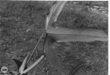
INFRUCTESCENCE with spadix to 22 cm long; berries red (at least apically), obovoid, ca. 7 mm long, 5 mm diam., obtuse al apex; mesocarp clear, gelatinous; seeds 2, greenish, ca. 3.5 mm long, 2.5 mm wide, 1.5 mm thick. Fig. 200.
The species is known from Costa Rica and Panama at 400 to 1,500 m elevation in premontane wet, tropical wet, and lower montane forest. It is a member of section Semaeophyllium and is not close to any other species in the section. It is distinguished by its deeply 3-lobed leaf blade, with the lateral lobes falcate, persistent cataphylls, and pale green to white spadix that is slightly tapered at both ends. In Costa Rica it can be confused only with A. subsignatum, which has blades only weakly 3-lobed and a bright yellow spadix. In Panama it has leaves similar to A. madisonianum Croat (incd.), which has a longer, reddish-violet spadix and prominently dilaceratcd cataphylls.
 |
Map of Mesoamerican specimens with coordinates
Costa Rica Alajuela: 820 m, 10.20N 84.40W, 13 JUN 1986, William A. Haber
ex E. Bello C., B. Hammel & L.Lierheimer 5116 (MO).
Costa Rica Alajuela: 10.12.53N 84.36.28W, 2 mayo 1987, Gerardo Herrera
Ch. 602 (MO).
Costa Rica Alajuela: 10.12.53N 84.36.28W, febrero 1987, Gerardo Herrera
Ch. 507 (MO).
Costa Rica Alajuela: 500 m, 10.55N 85.20W, 28 October 1987, Gerardo
Herrera 956 (MO).
Costa Rica Alajuela: 820 m, 10.20N 84.40W, 13 JUN 1986, William A.
Haber ex E. Bello C. B. Hammel & L.Lierheimer 5075 (MO).
Costa Rica Alajuela: 900 m, 10.18N 84.45W, 21 May 1987, William Haber
& Erick Bello 7167 (MO).
Costa Rica Alajuela: 900 m, 10.19N 84.44W, 23 July 1987, William Haber
& Erick Bello 7345 (MO).
Costa Rica Alajuela: 900 m, 10.18N 84.45W, 4 July 1988, Erick Bello
122 (MO).
Costa Rica Alajuela: 1560 m,, 3 Feb 1979, Thomas B. Croat 46922 (MO).
Costa Rica Alajuela: 300 m,, 5 Feb. 1976, Utley & Utley 4039 (MO).
Costa Rica Alajuela: 400 m,, 24 June 1976, Thomas B. Croat 36257 (MO).
Costa Rica Alajuela: 400 m,, 24 June 1976, Thomas B. Croat 36318 (MO).
Costa Rica Alajuela:, 25 Jan. 1986, Christenson 1109 (MO).
Costa Rica Cartago: 1135 m, 09.49.00N 83.24.30W, 2 March 1990, Michael
Grayum & Don Hodel 9726 (MO).
Costa Rica Cartago: 1250 m,, 1 July 1976, Thomas B. Croat 36685 (MO).
Costa Rica Cartago: 650 m,, 1979, Bogner s.n. (MO).
Costa Rica Guanacaste: 450 m, 10.40.00N 84.04.30W, 25 January 1985,
Michael Grayum, G. Herrera, O. Segura & P. Sleeper 4879 (B, CR, K,
MO, US).
Costa Rica Guanacaste: 850 m, 10.48N 85.19W, 14 August 1987, Gerardo
Herrera 707 (MO).
Costa Rica Guanacaste: 1100 m, 10.55N 85.28W, 15 July 1989, III INBio
53 (MO).
Costa Rica Guanacaste: 600 m, 10.45N 85.18W, 8 March 1988, Gerardo
Herrera 1614 (MO).
Costa Rica Guanacaste: 800 m, 10.48N 85.19W, 13 October 1987, Gerardo
Herrera 853 (MO).
Costa Rica Guanacaste: 1200 m, 10.23N 84.53W, 18 JUN 1986, William
A. Haber ex Eric Bello C. & April Clagget 5276 (MO).
Costa Rica Guanacaste: 1100 m, 10.23N 84.51W, 23 November 1987, William
Haber & Erick Bello 7820 (MO).
Costa Rica Guanacaste: 1100 m, 10.47.40N 85.18.35W, 1 October 1990,
Gerardo Rivera 683 (MO).
Costa Rica Guanacaste: Parque Nacional Ríncon de la Vieja, 900-1200
m, 10.47N 85.18W, 27-28 Jan 1983, Davidse et al. 23334 (MO).
Costa Rica Guanacaste:, , Standley & Valerio 45586 (US). Costa
Rica Guanacaste: Volcán Miravalles,, , Luteyn 3409 (DUKE).
Costa Rica Heredia: P.N. Braulio Carrillo, 500 m, 10.19.45N 84.04.50W,
26 January 1990, Abelardo Chacón 688 (CR, MO).
Costa Rica Heredia: 480-520 m, 10.18.30N 84.04.00W, 8 April 1986, Michael
H. Grayum 6916 (MO).
Costa Rica Heredia:, , Skutch 3735 (MICH). Costa Rica Limn: Río
Toro Amarillo, 275 m,, 9 Jan 1984, Thompson & Rawlins 1219 (MO).
Costa Rica Limn: Cordillera de Talamanca, 1000 m, 09.47.00N 83.20.30W,
10 Aug 1995, Grayum 10830 (CR, INB, MO).
Costa Rica Puntarenas: Monteverde,, , Jimenez s.n. (MO).
Costa Rica Puntarenas:, 26 July 1979, Jimenez 106 (MO).
Costa Rica San José: Alto Pacuare,, 21 July 1978, Ocampo, S. 2361 (MO).
Panama Bocas del Toro: 350-500 m, 8.54N 82.10W, 10 Mar 1986, Barry
Hammel, G. McPherson & L. Sanders 14720 (MO).
Panama Bocas del Toro: 600 m, 8.45N 82.18W, 25 June 1987, Croat 66786
(MO).
Panama Bocas del Toro: 3000 - 4000 f,, 21 June 1986, Kress et al. 86-1950
(MO).
Panama Chiriquí: Cerro Colorado, 1200-1500 m,, 14 Mar. 1976, Thomas
B. Croat 33365 (MO).
Panama Cocl: 800-900 m, 8.38N 80.09W, 12 July 1987, Thomas B. Croat
67201 (MO).
Panama Cocl: La Mesa, 860-900 m,, 21 July 1976, Thomas B. Croat 37354
(MO).
Panama Cocl: La Mesa,, , Wilbur et al. 15663 (DUKE).
Panama Panamá: 1000 m,, 16 June 1979, António 1086 (MO).
Panama Veraguas: Santa Fe Region,, 17 Oct. 1974, Mori & Kallunki
2589 (MO).
Panama Veraguas: Santa Fe Region,, 13 Apr. 1974, Nee 11226 (MO).
Panama Veraguas: Santa Fe Region, 800 m,, 7 Oct. 1979, António 2036
(MO).