![]()
![]()
Philodendron jacquinii Schott, Syn. Aroid. 90. 1856. TYPE:
Plate 152 in Jacq., Select Stirp. Amer. Hist. 1763 (holotype). Figures 231--232, 237, 241--242.
Philodendron hoffmannii Schott, Oesterr. Bot. Z. 8: 178. 1858 (as "P. hoffmanii"). TYPE: Costa Rica. Hoffmann s. n. (holotype, B [destroyed]). Schott ic. 2507 [neotype, W; here designated].
Philodendron deviatum Schott, Bonplandia 7: 29. 1859. TYPE: Venezuela, Fendler 1329 [lectotype, K; here designated].
Philodendron erlansonii I. M. Johnston, Sargentia 8: 89, t. 13. 1949. TYPE: Panama. Panamá: Perlas Archipelago: San José Island, along road about one-half mi. E of Red Hill, 31 Dec. 1945, Johnston 967 (holotype, GH).
Philodendron apocarpum Matuda, Madroño 10: 171. 1950. TYPE: Mexico. Chiapas: along Río Cintalapa, at Gilguero, 15 km E of Escuintla, Chiapas, ca. 200 m, 10 Aug. 1948, Matuda 18313 (holotype, MEXU; isotypes, F, MEXU).
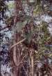
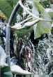
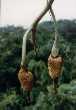
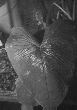
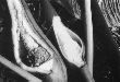
Hemiepiphytic vine; stem scandent, green to gray-brown, glossy, setose-pubescent; leaf scars conspicuous, 1 cm long, 1 cm wide; internodes elongate, 6--25 cm long, 0.8--1.5 cm diam., longer than broad, brownish gray, semiglossy, weakly asperous, epidermis paper-thin, sometimes peeling with age, drying gray-green to yellowish green, matte, sometimes almost blackened, larger stems drying yellow-brown and finely ridged; roots few per node, short, ca. 1 mm diam., light brown, sparsely scaly; cataphylls unribbed, semiglossy, 6--10 cm long, light green, translucent, drying cream-colored, deciduous intact; petioles 7.5--44.5 cm long, 5--10 mm diam., subterete, medium green, weakly glossy, narrowly and obtusely sulcate adaxially, surface setose-pubescent, often puberulous; blades broadly ovate-cordate, thin, chartaceous, acute to shortly acuminate, sometimes mucronate at apex (the acumen sometimes apiculate, 1--3 mm long), cordate at base, (10.5)11.5--39 cm long, 7.5--28 cm wide (0.99--1.8 times longer than wide), (0.6--1.85 times longer than petiole), usually about equal in length to petiole, broadest near point of petiole attachment, upper surface dark green, matte to subvelvety to weakly glossy, lower surface moderately paler, weakly glossy to almost matte, moderately paler; anterior lobe 8.3--27 cm long, 9--28 cm wide (1.6--3.4 times longer than posterior lobes); posterior lobes more or less rounded, 3--13.5 cm long, 3.4--13.6 cm wide, directed inward at maturity, rounded or obtuse; sinus more or less narrowly parabolic; midrib broadly convex, concolorous above, broadly convex to round-raised, often setose-pubescent near base, slightly paler below; basal veins 3--6 per side, with 0--1 free to base, 1--2 coalesced 0.5--2.5 cm; posterior rib not naked or briefly naked for 0.5 cm (rarely to 1.5 cm); primary lateral veins 2--3(4-5) per side, departing midrib at a 45--55E angle, more or less straight to the margins, prominently impressed to weakly convex above, convex to round-raised below; minor veins arising from both the midrib and primary lateral veins; tertiary veins obscurely visible to raised and conspicuous, darker than surface below. INFLORESCENCES erect, 1 per axil; peduncle (2)4--15 cm long, (2)3--6(7--13) mm diam., green, dark-striate, glabrous; spathe 10--16.5 cm long, (0.96--2.3(2.7--3) times longer than peduncle); spathe blade green outside, red inside; spathe tube inflated bulbous, green outside, 4 cm long, white or green inside; spadix sessile; 8--13 cm long, narrowly rounded at apex; pistillate portion 3--3.5 cm long, 3.5 cm long in front, 3 cm long in back, 3.5 cm diam. throughout; staminate portion 9.2 cm long; fertile staminate portion 1.5--1.6 cm diam. at base, 1.1 cm diam. at middle, 1 cm diam. ca. 1 cm from apex; sterile staminate portion narrower than the pistillate portion, 1.2--1.5 cm diam.; pistils 6.5--7.2 mm long, 2 mm diam.; ovary 4-locular, locules ca. 1.3 mm long, ca. 0.6 mm diam., with sub-basal placentation; ovules 2 per locule, contained within transparent, gelatinous matrix (no true envelope), 0.6--1 mm long, as long as or longer than funicle; funicle 0.4 mm long, (can be pulled free to base), style similar to style type B; style apex quite rounded; styles usually elongated to 5 mm long, sometimes essentially sessile; stigma hemispheroid to sometimes somewhat globular, lobed, 3.3 mm diam., 1.5 mm high, covering entire style apex; the androecium truncate, prismatic, some oblong, margins irregularly 4--6-sided, 1--1.7 mm long; thecae oblong, 0.5 mm wide, more or less contiguous; sterile staminate flowers irregularly 4--5-sided, 2.2 mm wide. INFRUCTESCENCE usually pendent, often from leafless stems; peduncle 7--15 cm long, recurved; spathe falling free; spadix (2.5)5--9(14) cm long, (1.5)2.5--7 cm wide; berries greenish when immature, pale orange to red to reddish orange when mature, irregular, 1 cm long, 5 mm diam.; seeds 4--6 per berry, white, ovoid, 4 mm long, 3--4 mm diam., moderately sticky. JUVENILE plants with petioles margins vaginate-winged almost to one-half their length; blades narrow ovate-cordate.
Flowering in Philodendron jacquinii occurs in August but most post-anthesis collections are from the rainy season, mostly June through September (but also November, January, and March). Immature fruits are known from virtually throughout the year, and mature fruits from March, June, and July. There seems to be little phenological variation in this species.
Philodendron jacquinii ranges from Mexico to Panama on both slopes of the Continental Divide to northern Colombia, Venezuela, and the Guianas, as well as western Cuba and the Cayman Islands, from sea level to 1500(2500)m elevation (mostly below 300 m), mostly in Tropical moist forest but also in Tropical dry forest, Premontane moist forest, and Premontane wet forest life zones.
This species, the only member of P. sect. Macrogynium, is distinguished by occurring in moderately low, dry habitats, and by its scandent habit, elongate internodes, setose-pubescent stems, petioles and veins of lower blade surfaces, subterete petioles (about equal the blades in length), and thin, ovate-cordate veiny blades. Especially characteristic are the generally swollen spathe tubes and elongated styles, making the pistillate portion of the spadix much broader than the staminate portion.
Philodendron jacquinii may be confused with P. brevispathum, another species with scaly petioles and thin blades with prominent posterior lobes. The latter species differs in having ovate-triangular blades with more slender, frequently flaring posterior lobes and a reddish brown stem with simple or branched scales lacking the elongated setae typical of P. jacquinii, which has typically greenish stems. In addition, the berries of P. jacquinii are pale orange to reddish and the spathe is reddish within (versus with berries whitish and the spathe green within for P. brevispathum).
For a discussion of the long-standing nomenclatural confusion involving P. hederaceum, see under the latter name. Although Standley & Steyermark (1958b) in their treatment of Araceae in the Flora of Guatemala, had the taxonomy correct in regards to this confusion, their illustration labeled P. hederaceum, (Fig. 58) appears to be a mixture of the two species, with the leaves of P. hederaceum and an inflorescence of P. jacquinii. The former species differs in lacking the setose-pubescence and scales characteristic of P. jacquinii, and in having more coriaceous blades as well as normal, short, closely compacted pistils. The spathe tube of the latter is also not markedly inflated.
A collection from El Salvador (Croat 42075) is unusual in lacking the usual trichomes on the stems.
Philodendron lundellii Bartlett ex Lundell (Bartlett 1937) also corresponds to this species, but the name was invalidly published (without a description or Latin diagnosis).
 |
 |
 |
 |
 |
Additional specimens examined.
BELIZE. Belize: Western Highway, Mile 35, Croat 24784 (F, MO); Belmopan, Gentry 8423 (MO); 9.5 mi. S of Georgeville, road to Augustine, Croat 23479 (MO); Hummingbird Highway, 7 mi. S of junction with Western Highway, N boundary of Roaring River Est., ca. 110 m, Spellman & Newey 1967 (GH, MO). Corozal: Gentle 530 (CM, MICH); Cerro Maya Ruins, Lowry's Bight, Crane 510 (LL), 418 (LL, MO); Gentle 345 (MICH). Orange Walk: Honey Camp, Lundell 99 (F, US); 2 mi. N of Orange Walk, Sutton et al. 122 (BM). Toledo: Maya Mountains, lower slopes of Richardson Peak, N of junction of Richardson Creek and Bladen Branch, 300--620 m, 88E46'30"W, 16E33--35'N, Davidse & Brant 31955 (B, MO). COSTA RICA. Alajuela. Orotina, Valle del Tárcoles, 100 m, Hammel & Grayum 19932 (CR, INB). Guanacaste. El Mirador, 450 m, Aguilar et al. 1343 (INB, MO). Heredia: La Selva Field Station, ca. 100 m, Hammel 10500 (MO); 1.4 km NW of Puerto Viejo, 75 m, Anderson & Mori 25 (CM). Puntarenas: Barranca Site, 15 mi. N of Puntarenas, Janzen 10742 (MO); Los Barrancas, along Pan-American Highway, near Miramar turnoff, Gentry 774 (MO); Río Guacimal, San Luis, Monteverde, 700 m, 10E16'N, 84E49'W, Bello et al. 20 (CR, MO); Monteverde Reserve, 1500 m, ca. 10E17'N, 84E48'W, Croat 61192 (CM, MO); 1300 m, Haber & Bello 7983 (CR, MO); Cantón de Buenos Aires, along Río Ceibo, Ujarrás, 500 m, 9E14'N, 83E18'W, Grayum 10228 (CR, INB, MO, US). San José: Mora, Colón--Hacienda El Rodeo, 800 m, 9E55'N, 84E16'W, Hammel 18579 (INB, MO). EL SALVADOR. Ahuachápan: San Francisco Menéndez--Tacuba, 0--2 mi. NE of San Francisco Menéndez, 200--450 m, Croat 42075 (MEXU, MO). GUATEMALA. Without locality. Heyde 463 (US); Aguilar 309 (F). Chiquimula: Río Chiquimula, Santa Bárbara--Petapilla, 4--6 mi. N of Chiquimula, 350--420 m, Standley 30245 (F); Las Mamacas, 16 mi. S of Guatemala City on CA-9, 3800 ft., Dziekanowski et al. 3472 (UMO). Jalapa: Jalapa--San Pedro Pinula, 1400--1800 m, Standley 77051 (F). Jutiapa: Standley 75385 (F); 75695 (F); 75212 (F); El Barrial, E of Jutiapan, ca. 800 m, Standley 75764 (F); Jutiapa--Las Tunas, NW of Jutiapa, 850--900 m, Standley 76294 (F). Petén: 31 km S of Flores, 175 m, Harmon & Dwyer 2797 (MO); La Libertad, Lundell 2551 (MICH); 1 km S on old trail to Mahaquila, Contreras 2912 (LL); Tikal National Park, Lundell 15292 (LL); 16792 (LL); Contreras 343 (LL); Dolores, Contreras 3763 (LL). Retalhuleu: Nueva Linda--Chaperico, 120 m, Standley 87774 (F). Santa Rosa: SE of Barberena, 1100--1800 m, Standley 77740 (F); Cuilapilla, 900 m, Standley 78087 (F); La Sepultura region, W of Chiquimulilla, 220 m, Standley 79331 (F); Chiapas, 3500 pp, Heyde & Lux 3867 (US); Yaxoquintela, floodplain of Río Santa Cruz (upper tributary of Río Usumacinta), 560 m, 16E58'N, 91E47'E, Rawlins 93 (CM). Zacapa: trail between Río Hondo and waterfall, 250--400 m, Standley 29396 (F); Quebrada Alejandria, summit of Sierra de Las Minas, Finca Alejandria, 2500 m, Steyermark 30856 (F); Mpio. Ocozocoautla, E edge of Selva del Ocote, 900 m, Breedlove 70760 (CAS, MO). HONDURAS. Colón: Trujillo, Capuchin Monkey Site West, Saunders 523 (MO); Bonito Oriental--Limón road, ca. 50 m SW of Río Piedra Blanca, 40 m, 15E46'30"N, 85E41'W, Evans 1086 (MO). Copán: 10 mi. W of Copán, road to La Entrada, 700 m, Croat 42517 (MO). Morazán: Río Yeguare drainage, ca. 14EN, 87EW, Williams 15908 (F); Río Yeguare, E of El Zamarano, ca. 750 m, Standley 15448 (F); Río de la Orilla region, SE of El Zamorano, 900--950 m, Standley 22404 (F). Olancho: Juticalpa, 380--480 m, Standley 17524 (F); Río Olancho, Gualaco--San Bonito Oriental, 7.4 mi. NE of San Esteban, 540 m, 15E20'N, 85E42'W, Croat & Hannon 64363 (MO). Yoro: Río Aguán, Coyoles, Yuncker et al. 8663 (F, GH, MICH, MO, NY, US); Río Guaymón, La Cieba--San Pedro Sula, SW of Tela, near border of Yoro and Atlántida, 50 m, 15E30'N, 87E43'W, Croat & Hannon 64666 (MO). MEXICO. Hahn s.n. (P). Campeche: Yucatán Peninsula, Champoton, Steere 1742 (CM); Maskall, Gentle 1186 (CM, MICH, NY); Tuxpena, Lundell 1074 (F). Chiapas: Arriaga--Las Cruces, 5.7 mi., ca. 160 m, Moore & Bunting 8923 (HB); 51 mi. NE of Chiapas--Oaxaca border on Hwy. 190 to Tuxtla Gutiérrez, 660 m, 16E47'N, 93E18'W, Thompson et al. 432 (CM, MO); 5 mi. N of Ocozocoautla, along road to Apitpac, 1000 m, Croat 40544 (MO); Río Cintalapa, Aguas Calientes, Escuintla, Matuda 18312 (NY); Esperanza, Escuintla, Matuda 18314 (MEXU, MO); Mpio. Berriozábal, 5 km E of Berriozábal, along Mexican Hwy. 190, 800 m, Breedlove & Thorne 30412 (MO); Mpio. Ocosingo, Río Usumacinta, 3 km. S of Frontera Corozal, 120 m, Martínez S. 7309 (MO); Mpio. Ocozocoautla, km 103--104 Hwy 190, 15.7 mi. E of Cintalapa, 3,050 ft., Bauml & Kimnach 527 (US); Río Grijalva, 10 km S of Hwy. 190 on road to Acala, at Nandaburri, 1600 ft., Laughlin 2811 (F). Guerrero: Acapulco, Palmer 462 (US). Oaxaca: Tuxtepec--Matias Romero, <100 m, Croat 78724 (CHIP, MO); 7.5 mi. SW of Tuxtepec on road to Valle Nacional, Moore & Bunting 8908 (HB); 14 mi. N of Puerto Escondido on Rte. 131 to Oaxaca, 300 m, 16E13--47'N, 97E5--8'W, Thompson et al. 424 (CM, MO); 5 mi. N of Palmar, 54 mi. N of junction of Highways 185 and 190, along Hwy 185, 65 m, Croat 40002 (MO); Parque Nacional de Laguna Temazcal, Temazcal, 150 m, 18E25'N, 96E25'W, Hammel & Merello 15454 (MO). Quintana Roo: Mpio. Chetumal, 6.5--7 km N of Tomás Garrido on the road joining Hwy. 186 west of Nicolas Bravo, 150 m, 18E6'N, 89E3'W, Saunders et al. 9950 (MO); 1 km E of Chanca Veracruz, E. Cabrera & H. Cabrera 4981 (MEXU). San Luis Potosí: Tamazunchale, Edwards 549 (F, MO). Veracruz: Córdoba--Veracruz, Ejido San José de Gracia below Penuela, Moore & Bunting 8877 (HB); San Lorenzo Tenochtitlán, 22--75 m, Wing 50 (GH). Yucatán: Schott 489 (BM); Mérida, Gaumer 489 (BM, F); Izamal, Gaumer 23174 (F) Gaumer 1422 (F); Greenman 376 (F); Gaumer 23823 (F, US). NICARAGUA. Boaco: Las Pitas, Camoapa, 400 m, 12E28'N, 85E35'W, Moreno 10643 (MO); Río Las Cañas, along Hwy. 33, ca. 3.1 km N of Hwy. 35 intersection, ca. 275 m, 12E38'N, 85E33'W, Stevens 5838 (MO). Chontales: Route 7, 5 km SE of Juigalpa, Moore 1622 (MO). Granada: Laguna de Apoyo, 110--180 m, 11E53'N, 86E01'W, Moreno 11178 (MO). Masaya: Parque Nacional Volcán Masaya, N slope of Volcán Santiago, ca. 375 m, 11E59'N, 86E10'W, Stevens 5267 (BM, MO); summit of Volcán Masaya, 500 m, Stevens 2950 (MO); Piedra Quemada, 2 km E of Volcán Masaya, 250 m, Stevens 4606 (BM, MO). Matagalpa: Ranchería, 11 km NE de Muy Muy, ca. 280 m, 12E46'N, 85E31'W, Moreno 24483 (AAU, MO); Río Yasica, Tuma, ca. 28 km NE Matagalpa, El Diamante, ca. 350--400 m, 13E04'N, 85E46'W, Guzmán et al. 915 (MO). Río San Juan: Boca de Sábalos, "La Toboba", 70--90 m, 11E03--04'N, 84E28--29'W, Robleto 1833 (US). Rivas: Tola--Las Salinas, El Coyol, ca. 2.3 km beyond entrance of Hda. Miramar, ca. 30--40 m, 11E23'N, 85E58'W, Stevens 9749 (BM, MO). Rivas-Carazo-Granada: Río La Pita--Río Escalante, ca. 20 m, 12E34'N, 86E08'W, Stevens 9718 (BM, MO). Zelaya: SW of Puerto Cabezas, 0--2 m, 14E01'N, 83E24'W, Stevens 7880 (MO); Mpio. Siuna, Wany, Ortiz 59 (MO). PANAMA. Canal Area: Balboa, Standley 29256 (US); road S-10 N of Escobal, Croat 12458 (MO, NY, U); Rodman Marine Base, Rodman Naval Ammunition Supply Depot, W of Balboa, 70--80 m, 8E58'N, 79E36'25"W, Howard 147 (MO); road to Cerro Pelado Radar Station, 0.5 km NW of Gamboa, 75--150 m, Nee 7760 (MO, RSA); Curundu, Parque Metropolitano, 8E58'N, 79E32'55"W, Croat & Zhu 76202 (MO); Gamboa, Croat 74755 (F, MO); Geologic Test Site N of Paraíso, Croat 12977 (MO); near Summit Hills Golf Course, Croat 10956 (MO); Gaillard Hwy., vic. Summit Golf Club, 40 m, 9E03'N, 79E37'W, Croat 69835 (AAU, MO, US); Radar Station Road, 1 mi. N of Summit Gardens, Croat 9080 (MO); Barro Colorado Island, Shattuck 115 (F, GH); Zetek 4675 (MO, US); Wheeler 5, Shattuck 215 (MO); laboratory clearing, Croat 10261 (MO); 9259 (MO); Colorado Point, Croat 6138 (MO); Vista Alegre, Zetek 5576 (MO); Chagres River, vic. of Juan Mina, Flat Rock, Bartlett & Lasser 16839 (MICH, MO); Fort Clayton, vic. of end of C-16 road, Blum 2243 (MO, SCZ); Ft. Sherman, Standley 31020 (US); Madden Dam Area, Boy Scout Road, Porter et al. 4062 (MO); Madden Forest, Las Cruces Trail, Croat 11878 (MO); 140 m, 9E06'20"N, 79E37'20"W, Croat & Zhu 77072 (MO); Pipeline Road, 2--4 mi. N of Gamboa, ca. 100 m, Gentry 6543 (MO); Río Cocoli, road K-9, Stern et al. 348 (GH, MO, US); Paraíso, Tyson & Lazor 6194 (F). Coclé: Penonomé and vic., 50--1000 ft., Williams 381 (NY). Darién: Cerro Pirre region, El Real, Croat & Porter 15460 (MO); Santa Fe region, Univ. of Georgia Cuipo Forest Site #2, 15 m, Duke 14258 (F, MO). Herrera: Ocú, Ebinger 1090 (MO, US). Los Santos: ca. 5 m S of Las Tablas, Burch et al. 1236 (MO, UC); Pocrí, Dwyer 1189A (MO); Las Tablas, Dwyer 1189 (MO). Panamá: along road to Bique, 5 km SW of Arraiján, 20--40 m, Nee 7699 (MO, US); Panamá Viejo, Rose 18505 (NY, US); road K-15 near Huile, vic. Gatún Lake, Smith et al. 3277 (F, US); El Llano--Chepo, Gentry & Tyson 1727 (MO, SCZ); Tocumen, Dwyer 4220 (MO); vic. Macambo, Croat 14911 (MO); Cerro Campana, Croat 12018 (MO, SCZ); Penonomé and vic., 50--1000 ft., Williams 381 (NY); San José Island, Pearl Archipelago, Erlanson 234 (US); 402 (GH, US); Johnston 974 (GH, MO), 918 (GH), 12 (GH), 960 (GH).