![]()
![]()
![]()
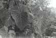
Philodendron verrucosum L. Mathieu ex Schott,
Syn. Aroid. 85. 1856. TYPE: Locality unknown (holotype, W?; lost?); Schott ic. 2757--2759 . [Neotype here designated]. Figures 437--440, 445.
Philodendron daguense Linden & André, Ill. Hort. 18: 192, t. 79. 1871. TYPE: Colombia. Valle: Río Dagua, Wallis s.n. (holotype, K).
Philodendron pilatonense Engl., Bot. Jahrb. Syst. 37: 129. 1905. TYPE: Ecuador. Pichincha: Río Pilatón, May 1899, Sodiro s.n. (holotype, B; isotypes, G, MO).
Philodendron discolor K. Krause, Notizbl. Bot. Gard. Berlin- Dahlem 9: 273. 1925. TYPE: Peru. Junín: Prov. Jauja, in the valley of Río Masamerich (Río Pontachuela) confluent of Río Pangoa, above Rasthütte Calabaza, 1500--1600 m, 11E30S, 7 May 1913, Weberbauer 6663 (holotype, B;isotype, F).
Usually hemiepiphytic,
rarely terrestrial or epiphytic; stem appressed-climbing, densely scaly or setose,
trichomes green to greenish white; pre-adult internodes to 20 cm long, 1--2
cm diam.; adult internodes smooth, scurfy, minutely wrinkled, semiglossy to
matte, 3--10 cm long, 2--6 cm diam., about as long as broad or longer than broad,
gray to brown, roots moderately numerous, mostly short, covered at least on
one side with fine root hairs, drying dark brown, semiglossy, faintly appressed-scaly;
cataphylls 10--30 cm long, unribbed, sometimes bluntly 1-ribbed, green or reddish,
densely scaly or setose, persisting as a tangled network of fibers.
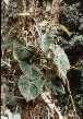
LEAVES erect-spreading; petioles 33--65(90) cm long, 3 cm diam. at
base, 1.5 cm diam. at apex, subterete, purplish violet to brownish, surface
densely scaly, the scales of two distinct types, short, broad, often lacerate
scales interspersed with long acicular scales, the latter erect, or spreading
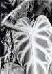
then erect; blades broadly ovate-cordate, thinly coriaceous, moderately
bicolorous, acuminate to narrow acuminate at apex (the acumen mostly inrolled,
1--2.5 mm long), cordate at base, 28--75 cm long, 19--60 cm wide (1--1.7 times
longer than wide), (0.7--1.5 times longer than petiole), broadest below point
of petiole attachment, upper surface dark green or bronze-green blackish green
on new leaves), velvety to matte, drying dark brown, yellow-green or gray-green,
lower surface pale green tinged red-purple between secondary veins (weakly glossy
and purple-violet on new leaves), matte, drying yellow-brown to reddish brown;
anterior lobe 9.6--51 cm long, 10--59 cm wide (1.9--3 times longer than posterior
lobes); posterior lobes 8--21 cm long, 5--28 cm wide, broadly rounded to obtuse;
sinus hippocrepiform to obovate or closed; midrib flat to sunken, slightly paler
than surface above, convex, matte, darker than surface below; basal veins 6--8
per side, with (0)1--2 free to base, numbers 3--4 coalesced 1--5 cm; posterior
rib not at all naked on small blades or naked for 0.5--6 cm; primary lateral
veins 3--6(8) per side, departing midrib at a 50--55E angle, sunken, paler than
surface above, round-raised to convex, darker than surface below; minor veins
distinct and darker than surface below, arising from both the midrib and primary
lateral veins; "cross-veins" conspicuous, in part raised below. INFLORESCENCES
1--4 per axil; peduncles 5--25 cm long, 1--2 cm diam., medium green to purplish,
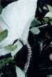
usually 0.66--1.75 times longer than the spathe; spathe densely scaly
or setose, 10--22 cm long, 4 cm diam.; spathe blade medium green, whitish or
reddish green outside, white to pinkish inside; spathe tube reddish green, medium
green, or dull purple-violet outside, red or pale reddish (dark green post-anthesis)
inside; spadix 14.6 cm long; pistillate portion cylindrical to weakly
clavate, 1.8--4.6 cm long, 1 cm diam. at apex, 8 mm wide at base; staminate
portion 9.4 cm long; fertile staminate portion cream; pistils 2.6--3.3 mm long,
1.4--1.7 mm diam.; ovary 4--5-locular, 1.9--2.5 mm long, 1.4--1.7 mm diam.,
with axile placentation; locules 1.9--2.5 mm long, 0.5--0.7 mm diam.; ovule
sac 1.8--2.2 mm long; ovules 20--24(34) per locule, 2-seriate, contained within
translucent, gelatinous ovule sac, 0.1--0.2 mm long, as long as or longer than
funicle; funicle to 0.2 mm long, adnate to lower part of partition, style 0.5--0.6
mm long, 1.4--1.7 mm diam., similar to style type B; style apex more or less
flat; stigma more or less lobed, 1.4 mm diam., 0.2--0.3 mm high, covering entire
style apex; the androecium truncate, prismatic, oblong, margins more or less
4--6-sided, 0.8--0.9 mm long, 2--2.5 mm diam. at apex; thecae oblong, 0.3--0.4
mm wide, more or less parallel to one another; sterile staminate flowers blunt,
irregularly 4--5-sided, sometimes clavate or prismatic, 1.6--1.8 mm long, 1.4--1.7
and 1.9--3.4 mm wide. INFRUCTESCENCE with ripe berries white.
Flowering in Philodendron verrucosum occurs from April through June (also September and November) in Central America. The species probably also flowers earlier in the dry season, perhaps as early as February, as suggested by the fact that a post-anthesis collection was made in March (and even in February in Colombia). Post-anthesis collections have also been made from April through July (but also in December). Immature fruits have been seen from July, October, and December. The flowering collections from September and October as well as the immature fruits from October and December appear to reflect bimodal flowering. On the other hand, no flowers were seen from July and no flowers or fruits from August.
Philodendron verrucosum ranges from Costa Rica to Peru at 200 to 1500 (mostly above 500) m elevation, mostly in Premontane rain forest and Tropical Lower Montane rain forest but also in Tropical wet forest. In Central America, it occurs principally on the Atlantic slope or near the Continental Divide in Costa Rica and Panama but also on the Pacific slope in southwestern Costa Rica. In South America, it ranges along the Pacific slope of the Andes to as far south as El Oro and Cotopaxi Provinces in Ecuador, but also occurs on the eastern slopes of the Andes in Napo and Morona-Santiago as well as in Peru in the departments of San Martín and Junín at 750 to 1850 m elevation.
Philodendron verrucosum is a member of P. sect. Philodendron subsect. Achyropodium. This species is characterized by its short internodes, subterete petioles (about as long as the blades), broadly ovate-cordate blades velvety on the upper surface, and especially by the densely scaly or setose vestiture of the stems, cataphylls, petioles and inflorescences.
Philodendron verrucosum might be confused with a few other species which have scaly parts, including P. hammelii, P. malesevichiae, P. squamipetiolatum, and especially P. squamicaule. See the latter species for a discussion of the differences. Philodendron squamipetiolatum differs by its longer, more slender internodes, and much smaller leaf blades (ca. 30 cm long on flowering plants) with a semi-glossy upper surface. It also differs in having solitary inflorescences (versus usually more than one per axil in P. verrucosum). Philodendron hammelii differs in its much smaller size, petioles with foliaceous (rather than acicular) scales restricted to near the apex, and glabrous cataphylls, peduncles, and spathes. Philodendron malesevichiae differs by its terrestrial, creeping habit, persistent, semi-intact, glabrous cataphylls, narrowly sulcate petioles (rather than subterete as in P. verrucosum), and semiglossy blades lacking the conspicuous "cross-veins" of P. verrucosum.
 |
 |
 |
 |
 |
Additional specimens examined.
COSTA RICA. Alajuela: Salto La Paz, 1350 m, Ferreyra 15788 (USM); San Ramón--Balsa, ca. 2.3 km N Río Balsa, ca. 1050--1150 m, 10E11'N, 84E30'W, Stevens 14194 (MO); ca. 4.6 km N of Río Balsa, 900--1,000 m, 10E12'N, 84E31'W, Stevens 13762 (CR, MO); 4--7 km N of Balsa, ca. 750 m, 10E13'N, 84E32'W, Liesner & Judziewicz 14763 (MO); 2.5 km N of Balsa, 1050--1100 m, 10E11'N, 84E30'W, Liesner & Judziewicz 14726 (CR, MO); Finca Los Ensayos, ca. 11 mi. NW of Zarcero, ca. 850 m, Croat 43636 (MO); 2 km N of Angeles Norte de San Ramón, 4000 ft., Luteyn 3691 (MO); ; Zarcero--Quesada, 11.8 km past Zarcero, 1230 m, 10E12'N, 84E23'W, Hoover 1352 (CR, MO); E of Río San Rafael, W of La Marina, 500 m, 10E23'N, 84E38'W, Burger & Stolze 5041 (CR, US); Monteverde Biological Reserve, Río Peñas Blancas, 900 m, 10E18'N, 84E45'W, Haber & Bello 8458 (CR, MO); 820 m, Bello 2672 (CR); 850--900 m, 4478 (CR, INB); 950 m, Bello & Méndez 2639 (CR, INB); Cantón Alfaro Ruiz, La Peña de Zarcero, Smith 961 (F); Los Chiles--Los Angeles, San Ramón, 500--1200 m, 10E10'N, 84E30'W, Barringer et al 2200 (CR, MO); E. Schmidt 306 (CR). Cartago: 4000 ft., J. D. Smith 391 (G); Moravia--Quebrada Platanillo, Moravia, 3--5 km from Finca Racine, 1200--1300 m, Croat 36623 (MO); 1200--1400 m, 36795 (MO); Turrialba--Limón, along Hwy. 32, ca. 11 mi. NE of Turrialba, 850 m, Croat 43355 (CR, MO); 31 km S of Siquirres on road to Turrialba (CR-101), 850 m, 9E57'N, 83E36'W, Thompson & Rawlins 1163 (CM); El Muñeco, S of Río Navarro, 1400--1500 m, Standley & Torres 51745 (CM, US); Standley 33425 (US); Finca Navarro, 1350 m, Maxon 636 (NY, US); 10 km S of Tapantí, 1600 m, 9E42'N, 83E46'W, Burger & Burger 8424 (CR, F); 3.5 km SE of Tapantí, 1250 m, Lent 851 (F, NY, US); Río Grande de Orosi, 2 km SE of Tapantí, 1350, Lent 763 (F); 14 mi. from Turrialba, road to Pavones, Carlson 3244 (F); Orosi, Standley 39736 (US); La Estrella, Standley 39547 (US); 4250 ft., J. D. Smith 5963 (US); Río Gato, 4 km SE of Pejibaye, 700 m, 9E48'N, 83E42'W, Liesner 14412 (MO); Tapantí Hydroelectric Reserve, 3--5 km from the gate, D. Smith & Taylor 1009 (MO); 1300--1800 m, Gómez 18889 (MO, RSA); Tapantí region, 1.5 km past Río Macho, along small stream along road to Humo, 1330 m, 9E17'N, 83E50'W, Hoover 1345 (CR, MO); 4250 ft., Cooper 5963 (CM, GH, US); Tucurrique, Las Vueltas, 635-700 m, Tonduz 13321 (US); Reventazón Valley, Juan Viñas, Cook & Doyle 288 (US). Heredia: 4 mi. N of Vara Blanca, 1350 m, Croat 35609 (MO); 3 mi. S of Cariblanco, 760 m, Croat 35794 (MO); La Selva Field Station, 280--300 m, 10E21'N, 84E03'W, Schatz & Grayum 721 (DUKE). Limón: Cerro Chimú--Cerro Matama, 1200 m, Gómez & Herrera 23533 (MO, US); Talamanca, Tsaki, 200 m, Tonduz 9512 (CR, US); Fila Matama, 850 m, Robles & Chacón 2724 (CR, MO). Puntarenas: Las Cruces Botanical Garden--Río Jaba, ca. 3 km SE of San Vito de Coto Brus, ca. 1050--1200 m, 8E47'N, 82E58'W, Grayum 5621 (CR, MO); Monteverde Reserve, 1500 m, 10E17'N, 84E48'W, Hammel & Zuchowski 13886 (MO). San José: San Isidro del General--Dominical, 4.8 mi. from Río Pacuare, 1000 m, Croat 35251 (MO); 9 mi. SW of Río Pacuar, 680 m, Croat 35349 (MO); Bijagual, 1300 m, Gómez 20564 (M, MO, QCA); Alto San Juan, road to Dominical, 900 m, Molina et al. 18096 (F, NY); La Hondura, 1300--1700 m, Standley 37783 (US); Río Claro Valley (Bajo La Hondura), below La Palma, NE of San Jerónimo, 1000--1200 m, 10E3'N, 83E58'W, Burger et al. 9433 (CR, F, U); below La Palma NE of San Jerónimo, 1000--1200 m, 10E3'N, 83E58'W, Burger et al. 9386 (F, MO), Burger & Gentry 9077 (CR, F); 1500 m, 10E3'N, 83E58'W, Burger & Stolze 5308 (CR, F), 8499 (F); Tarrazú, vic. Hormiguero, 1100--1200 m, Croat 78935 (INB, MO). PANAMA. Bocas del Toro: Cerro Colorado, 9.2 mi. W of Chame, 1450--1480 m, 8E35'N, 81E50'W, Croat 69010 (MO); Fortuna Dam area, Chiriquí Grande--Gualaca, 21.4 km past Gualaca, 8E32'N, 82E19'W, Hoover 1327 (MO); Continental Divide, ca. 1200 m, ca. 8E45'N, 82E15'W, McPherson 9033 (CAS, CM, K, MO); Croat 60374 (MO); Old Bank Island, vic. of Chiriquí Lagoon, von Wedel 1923 (MO). Chiriquí: Volcán Cañas Gordas, 1 m E of Cañas Gordas, Croat 22344 (MO); Cerro Colorado, 34.1 km beyond Río San Félix, 1390 m, Croat 37254 (MO); Gualaca--Chiriquí Grande, vic. IRHE headquarters, 1200 m, 8E45'N, 82E18'W, Croat 66719 (MO); 66558 (AAU, MEXU, MO, NY, PMA); road to Finca Landau, 1100 m, Correa et al. 2141 (F, MO, PMA); NW of confluence of Río Hornito and Río Chiriquí, 1050--1100 m, 8E44'N, 82E13'W, Sytsma & Stevens 2234 (MO, PMA); Fortuna Dam, Cerro Fortuna, lower slopes, 1150 m, Knapp & Vodicka 5576 (MO); behind Vivero Forestal, 12 km N of Los Planes de Hornito, 1200--1300 m, 8E45'N, 82E12'W, Knapp 4949 (MO); 7 km SE of Fortuna Dam, 1100 m, O'Connor 91-512-004 (MICH); Continental Divide, 1200--1500 m, 8E47'N, 82E13'W, Churchill 5298 (MO); 1200 m, O'Connor 91-511-003 (MICH); Continental Divide trail, 1200-1300 m, 8E45'N, 82E15'W, Thompson 4954 (CM, MO). Coclé: El Copé region, Alto Calvario, near Continental Divide, 5 mi. N of El Copé, 900--1,000 m, 8E39'N, 80E36'W, Croat 75058 (MO); 750--900 m, 44736 (MO); 89E39'N, 80E36'W, 68768 (CM, F, MO); El Valle region, La Mesa, Gentry 5632 (MO, PMA); 860--900 m, Croat 37339 (MO); 13341 (MO); 900 m, Sullivan 544 (MO); Liesner 756 (MO); NE slopes of Cerro Caracoral, N rim of El Valle, 2700--3200 ft., Sytsma 3787 (MO); Cerro Pilón, 5 km NE of El Valle, 800--1045 m, Mori et al. 6633 (MO); Lallathin 5096 (MO); Cerro Gaital, 900--1000 m, 8E40'N, 80E07'W, Knapp 5301 (MO); 800--900 m, Knapp & Dressler 4913 (MO); 5.6 kms S of El Valle, 870 m, 8E50'N, 80E07'W, Hoover 1319 (MO, NY); ca. 3 km N of El Valle de Antón, 850 m, Wilbur et al. 15656 (MO). Darién: Cerro Pirre region, 1000--1100 m, Hartman 4829 (MO); 9-10 km N of Alto de Nique, 1520--1560 m, Croat 37871 (MO); Río Tuquesa, vic. of Tyler Kittredge gold mine, ca. 2 air km from Continental Divide, Croat 27215 (MO). Panamá: El Llano--Cartí, 12 mi. above Pan-American Highway, 200--500 m, Liesner 689 (MO); Campo Tres, 3 mi. NE of Altos de Pacora, 500--800 m, Croat 22716 (MO); Cerro Campana, 1000 m, Nee & Stockwell 11625 (MO); Croat 17200 (MO); ca. 850 m, 8E40'N, 79E50'W, Thompson 4576 (MO); 850 m, Busey 875 (MO); above Su Lin Motel, Croat 14728 (MO); near Florida State Univ. Building, Croat 12121 (F, MO, SCZ). San Blas: Cerro Habú, vic. of peak, 2500 ft., 9E23'N, 78E49'W, Sytsma et al. 2699 (MO, US); Cerro Brewster, 850 m, 9E18'N, 79E16'W, de Nevers et al. 5546 (MO); Cerro Obu, 400--500 m, de Nevers et al. 8053 (MO); Nusagandi, 310 m, 9E20'N, 79EW, Croat & Zhu 76993A (MO). Veraguas: Santa Fe region, NW of Santa Fe, 11 km from Alto Piedra, Río Dos Bocas Valley, 450--550 m, Mori et al. 3815 (MO, PMA); NW of Santa Fe, along W fork of road beyond Alto Piedra, 0.6 mi. beyond fork in the road, 1300--1350 m, Croat 49060 (MO); Santa Fe--Río Calovébora, 0.6 mi. beyond Alto Piedra, 735 m, Croat & Folsom 33991 (MO); 1.7 mi. past Alto Piedra, 1.5 mi. beyond Quebrada Cosilla, 570 m, 8E33'N, 81E08'W, Croat & Zhu 76856 (MO).