


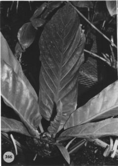
LEAVES erect; petioles flattened or sulcate adaxially, rounded abaxially, 5-23 cm long, 1-2 cm diam.; geniculum 1.6-2 cm long; blades obovate to oblanceolate, moderately thick, acuminate at apex, attenuate, sometimes cuncate (rarely rounded or subcordate) at base, (32) 40-180 cm long, (9)13-50 cm wide; both surfaces semiglossy; the midrib acutely raised above and below; primary lateral veins 9-14 per side, raised above and below; lesser veins less conspicuous.
INFLORESCENCE usually pendent, shorter than leaves; peduncle 16-80 cm long; spathe lanceolate-linear, moderately thin, purple or green sometimes tinged purple, 4-45(50) cm long, 1-5 cm wide; gradually cuspidate-acuminate at apex, rounded to truncate at base; spadix dull green soon tinged throughout with lavender (B 6 K Purple 6/5), 6-34(47) cm long, 0.6-1.5 cm diam. at base, 2-7 mm diam. at apex; flowers rhombic, 2.4÷2.5 mm in both directions, the sides straight to sigmoid; 6-7 flowers visible in the principal spiral, 8-12 flowers visible in the alternate spiral; tepals matte, lateral tepals 1.2-1.3 mm wide, the inner margins broadly rounded; pistils green, emergent but not raised; stigma linear, ca. 0.9 mm long; stamens emerging in a slow progression from the base; anthers pale yellow, held at edge of tepals and laying over pistil; the-cae ellipsoid; pollen pale yellow-orange, fading to white.
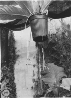
INFRUCTESCENCE with spadix to 60 cm long; berries red, oblong-elliptic, rounded at apex, 1-1.5 cm long; seeds 2, oblong, flattened, 3.3 mm long. Figs. 166 and 167.
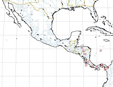
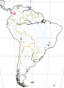
The species occurs in western Mexico (Chiapas) along the Pacific slope of Guatemala and along both the Atlantic and Pacific slopes from Nicaragua to Panama. There is also a single collection from Honduras (Atlantic slope) that appears to be this species. The species also occurs in Colombia and has been collected in Chigorodo and Dabeiba in Antioquia. Anthurium salviniae occurs from near sea level to 1,400 m, in wetter parts of tropical moist forest, in premontane wet, tropical wet, and also, rarely, in premontane rain forest.
Anthurium salviniae has long been called A. tetragonum but that name is a synonym of A. schlechtendalii, a species ranging from Mexico to Honduras or Nicaragua on the Atlantic slope. Although leaves of the two species are very similar, A. salviniae is a member of section Pachyneurium and can be distinguished by its long-tapered, pale lavender spadix, long-tapered spreading spathe, and fist-shaped, cucullate cataphylls. In addition the leaves of A. salviniae usually dry darker and thinner. Anthurium schlechtendalii usually has a shorter, blunter spadix and a short, thick spathe that is usually reflexed and often twisted. The spadix is darker violet-purple and is not at all glaucous at anthesis.
A collection in cultivation at Missouri Botanical Garden from the Río Maje region of Panama in Panama Province is unusual in having dark violet-purple rather than red berries.
 |
 |
Map of Mesoamerican specimens with coordinates
Costa Rica Alajuela: 1100-1300 m, 10.12.40N 84.36.20W, 4 February 1991,
Jens Bittner 528 (MO).
Costa Rica Alajuela: 200 m,, 26 June 1976, Thomas B. Croat 36480 (CO,
NYL, F, MO).
Costa Rica Alajuela:, , Thomas B. Croat 43640 (MO).
Costa Rica Alajuela: Buena Vista de Zarcero, 900-1000 m, 10.16N 84.27W,
26 Nov 1983, Judziewicz 4404 (WIS).
Costa Rica Alajuela: Río Cacao, 800 m,, , Gomez 19568 (MO).
Costa Rica Alajuela: 1560 m,, , Thomas B. Croat 46916 (MO).
Costa Rica Cartago:, , Thomas B. Croat 36808 (MO).
Costa Rica Cartago:, , Lent 1034 (GH).
Costa Rica Guanacaste: Cerro Nubes, 900 m, 10.28N 84.53W, 25 January
1985, Grayum et al. 4999 (MO).
Costa Rica Guanacaste: Parque Nacional Rincón de la Vieja,,
28 Jan 1983, Garwood et al. 746B (BM).
Costa Rica Guanacaste: Lake Arenal, 550-850 m, 10.27N 84.50W, 9 May
1986, Hammel et al. 15146 (MO).
Costa Rica Guanacaste:, , Standley & Valerio 44445 (US).
Costa Rica Guanacaste: 450 m, 10.40.00N 84.04.30W, 25 January 1985,
Michael Grayum, G. Herrera, O. Segura & P. Sleeper 4875 (MO). Costa
Rica Guanacaste: Parque Nacional Ríncon de la Vieja, 900-1200 m, 10.47N
85.18W, , Davidse et al. 23335 (CR, K, MO).
Costa Rica Puntarenas: Monteverde, 1150-1250 m, 10.18N 84.48W, 29 Jan
1991, Haber & Zuchowski 10485 (MO, CR).
Costa Rica Puntarenas: 1500 m, 10.15N 84.48W, 25 September 1990, Norman
Obando en el Curso II de Parataxonomos 147 (MO).
Costa Rica Puntarenas:, , Thomas B. Croat 32898 (MO).
Costa Rica Puntarenas: Cordillera de Talamanca, 1100-1200 m, 09.04.30N
85.05.00W, , Davidse & Herrera 26240 (MO).
Costa Rica Puntarenas: Las Cruces, 1100 m, 08.47.30N 82.58.00W, 4 Sep
1993, Vargas, G. et al. 1310 (CR).
Costa Rica Puntarenas: Península de Nicoya, 0-200 m, 09.35.40N
85.07.50W, 18 Jan 1996, Hammel et al. 20098 (MO).
Guatemala Escuintla:, , Standley 63469 (F).
Guatemala Retalhuleu:, , Standley 88227 (F).
Guatemala Retalhuleu:, , Standley 87499 (F).
Guatemala Retalhuleu:, , Standley 88391 (F).
Guatemala Sacatepequez:, , Standley 58294 (F).
Guatemala San Marcos:, , Thomas B. Croat 40902 (CM, K, MEXU, MO, USCG).
Guatemala San Marcos:, , Thomas B. Croat 40903 (MO).
Guatemala Santa Rosa:, , Standley 78060 (F).
Guatemala Santa Rosa: 3500 ft,, , Heyde & Lux 4278 (G, K, NY, US).
Guatemala Santa Rosa: Naranjo, 3500 pp,, Dec 1892, Smith, John Donnell
4278 (G).
Guatemala Suchitepequez:, , Thomas B. Croat 32786 (MO).
Honduras Atlántida: Lancetilla Valley,, , Standley 53228 (US).
Honduras Atlántida: 400 m, 15.42.00N 86.50.50W, 26 April 1996,
Thomas Hawkins 941 .
Honduras Comayagua: 600 m, 14.42N 79.52W, 10 May 1991, Davidse 34333
(MO).
Honduras Olancho: 400 m, 14.45N 86.00W, 4 Feb. 1987, Thomas B. Croat
& Dylan P. Hannon 64142 (MO).
Mexico Chiapas:, , Thomas B. Croat 43845 (MO).
Mexico Chiapas:, , Thomas B. Croat 43877 (MO).
Mexico Chiapas: 300 m.,, , Matuda s.n. (MEXU, PMA).
Mexico Chiapas:, , Matuda 16377 (F, MEXU, MO).
Mexico Chiapas:, , Matuda 16776 (F, MEXU).
Mexico Chiapas:, , Matuda 18043 (MEXU, UCLA).
Mexico Chiapas:, , Matuda 18381 (DS, MEXU).
Mexico Chiapas:, , Matuda 18519 (DS, MEXU, UCLA).
Mexico Chiapas:, , Thomas B. Croat 47572 (MO).
Mexico Chiapas:, , Thomas B. Croat 47573 (MO).
Mexico Chiapas:, , Miranda 1763 (MEXU).
Nicaragua : Quebrada El Quebradon, 950-1000 m, 13.14N 85.39W, , Stevens
& Riviere 20892B (MO).
Nicaragua : 1000-1400 m, 13.14N 85.38W, , Stevens et al. 21035 (MO).
Nicaragua Jinotega: 1100-1150 M, 13.05N 85.53W 13.06N 85.54W, 31 October
1979, W.D. Stevens & A. Grijalva 15326 (MO).
Nicaragua Jinotega: 1100-1150 M, 13.05N 85.53W 13.06N 85.54W, 31 October
1979, W.D. Stevens & A. Grijalva 15325 (MO).
Nicaragua Matagalpa: Quebrada El Quebradon, 1400-1600 m, 13.15N 85.39W,
, Stevens et al. 21219 (MO).
Nicaragua Río San Juan:, , C.L. Smith 87 (MO).
Nicaragua Zelaya: 800-1000 m, 13.45N 85.00W, 9 March 1978, W.D. Stevens
6793 (MO).
Panama Canal Area:, , Standley 28564 (MO).
Panama Canal Area: Barro Colorado Island,, , Bailey & Bailey 72
(BH).
Panama Canal Area: Barro Colorado Island,, , Thomas B. Croat 4231 (MO).
Panama Canal Area: Barro Colorado Island,, , Thomas B. Croat 4554 (MO).
Panama Canal Area: Barro Colorado Island,, , Croat 6511 (MO).
Panama Canal Area: Barro Colorado Island,, , Croat 7292 (MO).
Panama Canal Area: Barro Colorado Island,, , Croat 7920 (MO, PMA).
Panama Canal Area: Barro Colorado Island,, , Croat 8495 (MO).
Panama Canal Area: Barro Colorado Island,, , Croat 8512 (MO).
Panama Canal Area: Barro Colorado Island,, , Croat 9534 (MO).
Panama Canal Area: Barro Colorado Island,, , Thomas B. Croat 10195
(MO, PMA).
Panama Canal Area: Barro Colorado Island,, , Thomas B. Croat 11325
(MO).
Panama Canal Area: Barro Colorado Island,, , Ebinger 181 (MO).
Panama Canal Area: Barro Colorado Island,, , Shattuck 638 (MO).
Panama Canal Area:, , Standley 27210 (US).
Panama Canal Area:, , Gaillard 2698 (US).
Panama Canal Area:, , Pittier 2679 (US).
Panama Canal Area: Gatun Lake,, , Standley 31343 (US).
Panama Canal Area:, , Pittier 2278 (US).
Panama Canal Area:, , Dodge & Hunter 8651 (G, MO).
Panama Canal Area:, , Dodge & Hunter 8659a (MO).
Panama Canal Area:, , Dodge & Hunter 8662 (MO).
Panama Canal Area: Madden Dam,, , Dodge 16579 (MO).
Panama Canal Area:, , Standley 31719 (US).
Panama Canal Area:, , Bartlett & Lasser 16609 (MICH, MO).
Panama Canal Area:, , Steyermark & Allen s.n. (G, MO).
Panama Canal Area: Río Casaya,, , Nee 9024 (MO).
Panama Canal Area: Río Indio de Gatun,, , Pittier 2801 (US).
Panama Canal Area:, , Dodge et al. s.n. (G, MO).
Panama Canal Area:, , Thomas B. Croat 10281 (MO).
Panama Canal Area: Barro Colorado Island,, , Thomas B. Croat 32983
(M, MICH, MO, RSA, TEX).
Panama Chiriquí: 1200-1500 m,, 12 March 1976, Thomas B. Croat 33085
(B, C, INPA, K, MBM, MO, US).
Panama Chiriquí: Cerro Colorado,, , António 1527 (MO).
Panama Chiriquí: 800 - 1200 m,, , Thomas B. Croat 33498 (MO, UCLA,
WU).
Panama Chiriquí: Puerto Armuelles region,, , Busey 593 (MO).
Panama Chiriquí:, , Liesner 1075 (MO, US).
Panama Coln: Portobelo Region, 0-50 m, 09.30N 79.40W, , Knapp et al.
4609 (MO).
Panama Coln: Portobelo Region, 0-50 m, 09.30N 79.40W, , Knapp &
Schmalzel 3598 (MO).
Panama Coln: Río Boqueron, 50 m, 09.35N 79.32W, , Knapp et
al. 5826 (MO, B).
Panama Darien: Río San António, 130 m, 7.5N 78.2W, 22 March
1986, Hammel et al. 14802 (MO).
Panama Darien: Río San António, 130 m, 7.59N 78.25W, 22 March
1986, Hammel et al. 14811 (M, MO).
Panama Darien: Parque Nacional del Darién, 450-600 m, 8.3N 77.20W,
, Hammel et al. 16193 (MO)
Panama Darien: Cerro Tacarcuna,, , Gentry & Mori 13892 (MO).
Panama Darien:, , Duke 5235 (MO).
Panama Darien:, , Sytsma & D'Arcy 3433 (K, MO).
Panama Darien: Cerro Pirre Region,, , Thomas B. Croat 37751 (MO).
Panama Panamá: 180 m, 09.14.25N 79.05.00W, 22 July 1994, Thomas B.
Croat & Guanghua Zhu 77044 (MO).
Panama Panamá:, , Nee 8566 (MO).
Panama Panamá:, , Pittier 2344 (US).
Panama Panamá: Cerro Brewster,, , Lewis et al. 3475 (MO).
Panama Panamá: Río Maje,, , Thomas B. Croat 34441 (MO).
Panama Panamá: Río Maje,, , Thomas B. Croat 34600 (F, K, MO,
US).
Panama Panamá:, , Folsom et al. 6584 (MO).
Panama Panamá:, , Folsom & Collins 1701 (MO).
Panama Panamá:, , Duke 11427 (OS).
Panama Panamá: 100 m, 08.57N 79.32W, , Churchill & de Nevers 4479
(MO).
Panama Veraguas: 800-900 m, 8.33N 81.08W, 8 Jan. 1992, Thomas B. Croat
71981 (MO, WU).
Map of South American Specimens with coordinates
Colombia Antioquia: 10 m,, 24 March 1986, Renteria et al. 4776 (MO).
Colombia Antioquia: 10-20 m.,, 24 Dec. 1983, Brand & Escobar 727
(MO)
. Colombia Antioquia: Río Sucio,, , Gutiérrez & Barkley
1822 (COL, US).
Colombia Antioquia: Río Sucio,, , W. Johnson & F.A. Barkley
18C411 (US)
. Colombia Antioquia: Mpo. Chigorodo,, , Plowman 3175 (GH).
Colombia Antioquia: 180-400 m,, , Callejas et al. 4783 (MO).
Colombia Antioquia: Río Claro, 05.54N 74.51W, , Croat 56579
(MO).
Colombia Caldas: La Primera Quiebra, 1800 m, 5.30N 75.33W, 5 Nov. 1990,
Arias 55 (MO, SAR).
Colombia Choco: 50 m, 6.16N 77.21W, 13 January 1984, Adrian Juncosa
1879 (MO).
Colombia Choco: Zona de Urabá, 50-200 m,, 18 May 1988, Cardenas
1959 (MO).
Colombia Quindio: Río La Vieja, 1000 m,, 6 May 1984, Arbelaez
et al. 333 (MO).