


Anthurium flexile Schott,
Oesterr. Bot. Z. 8: 1 80. 1858.
Anthurium flexile ssp. flexile. TYPE: Costa Rica. Heredia: Pedregel, Wendland 932 (GOET, holotype).
Anthurium myosuroides (H.B.K.) Endl. var. angustifolia Engl., Bot. Jahrb. Syst. 25: 382. 1898. TYPE: Costa Rica. Limn: Matina, Pittier 9797 {Pittier 9767?) (BR, CR, US).
Scandent epiphyte; the stem elongate; internodes 2-6 cm long, ca. 3 mm thick; roots slender, 1-2 cm long, scattered along the internodes; cataphylls to 4 cm long.
LEAVES spreading; petioles 4÷11 cm long, flattened to sulcate adaxially; blade elliptic or narrowly elliptic, (10)1 3-26.5 cm long, (2.5)3-9(10.5) cm wide, acuminate to long-acuminate at apex, narrowly subcordate, pliveined at base, the upper surface semiglossy; midrib sunken; collective vein arising from the base or fused with the midrib for 0.2-2.5 cm from base.
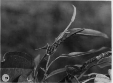
INFLORESCENCE usually arching-pendent; penduncle 4-23 cm long, terete; spathe green, lanceolate, 3.5-9.5 cm long, 0.7-1.8 cm wide; stipe absent or to 2 mm long; spadix violet-purple at an thesis, 4.5-13 cm long, 0.3-0.5 cm diam. at base, usually less than 1 cm diam. at apex.
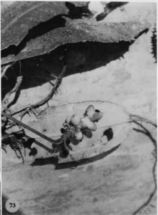
INFRUCTESCENCE with spadix to 2 cm diam.; berries oblong-ellipsoid to narrowly ellipsoid or narrowly ovoid (with four longitudinal ridges on drying), orange to red, 0.5-1.2 cm long, with numerous round to slightly elongated raphide cells visible on drying; mesocarp orange, pulpy; seeds (1)2(3), black, suborbicular, flattened, ca. 6-9 mm long. Figs. 69, 73, and 75.
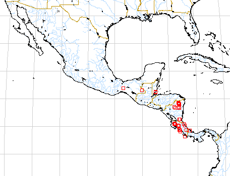
Anthurium flexile is a member of section Polyphyllium and consists of two subspecies. The ssp. flexile ranges from Mexico to Panama at 0 to 1,000 m elevation in tropical wet forest life zones. It is distinguished from ssp. muelleri by the characters listed in the Key. For a discussion of these differences sec the discussion of ssp. muelleri
 |
 |
 |
Map of Mesoamerican specimens with coordinates
Belize Belize:, , Gentle 3852 (MICH).
Belize Toledo:, 10 January 1948, Gentle 6359 (LL).
Belize Toledo: Río Blanco,, 20 March 1951, Gentle 7243 (LL).
Belize Toledo: 40 m,, 25 May 1979, Whitefoord 1853 (BM).
Belize Toledo:, 11 June 1981, Whitefoord 3189 (BM).
Belize Toledo: 400 m, 16.27.35N 088.58.52W, 19 May 1997, Gerrit Davidse
& D.L. Holland 36609 (BRH, MO).
Belize Toledo: 420 m, 16.28.25N 088.59.43W, 21 May 1997, Gerrit Davidse
& D.L. Holland 36652 (BRH, MO).
Belize Toledo: 450 m, 16.28.28N 088.57.59W, 27 May 1997, Gerrit Davidse
& D.L. Holland 36843 (IBE, MO, WU).
Costa Rica Alajuela: 350 m, 10.58N 85.20W, 1 April 1988, Gerardo Herrera
1662 (MO).
Costa Rica Guanacaste: 475-500 m, 10.40.30N 85.04.30W, 24 January 1985,
Michael Grayum & Gerardo Herrera 4862 (MO).
Costa Rica Guanacaste: 1000 m,, 17 Feb 1984, Khan et al. 1140A (BM).
Costa Rica Guanacaste: 800-940 m, 10.47N 85.19W, 26 Jan 1986, Michael
H. Grayum, P. Sleeper, A. R. Smith & T. Béliz 6264 (MO).
Costa Rica Guanacaste: 1100 m, 10.55N 85.28W, 15 July 1989, II INBio
194 (MO).
Costa Rica Guanacaste: Parque Nacional Guanacaste, 1060 m, 10.55.45N
85.28.15W, 2 June 1990, Varela et al. 34 (MO).
Costa Rica Guanacaste: 1100 m, 10.23N 84.51W, 23 November 1987, William
Haber & Erick Bello 7823 (MO).
Costa Rica Guanacaste: 1000 m, 10.46.05N 85.17.40W, 17 September 1990,
Gerardo Rivera 602 (MO).
Costa Rica Guanacaste: P.N. Rincón de la Vieja; Cordillera de
Guanacaste, 1200 m, 10.47.50N 85.21.10W, 13 January 1993, Dunia Garcia
51 (CR).
Costa Rica Heredia: Finca La Selva, 100 m,, , Wilbur 37197 (DUKE).
Costa Rica Limn: 150 m, 09.39N 83.02W, 1 August 1985, Michael H. Grayum,
B. Hammel, L. Bermúdez & R. Acosta 5793 (MO).
Costa Rica Limn: 25-40 m, 09.35N 82.39W, 19 Nov 1984, Michael Grayum
4481 (MO).
Costa Rica Limn:, 1895, Pittier 9767 (BR). Costa Rica Limn: 0 m,
10.27.00N 83.35.00W, 1 December 1990, José Solano 251 (MO).
Costa Rica Puntarenas: 30-40 m, 09.47N 84.37W, 11 January 1985, Michael
Grayum 4762 (MO).
Costa Rica Puntarenas: 50 m, 8.27N 83.33W, 11 July 1988, C. Kernan
& P. Phillips 685 (MO).
Costa Rica Puntarenas: Reserva Biológica Carara, 50 m, 09.49N
84.34W, 12 Jan 1990, Zuñiga 84 (MO).
Costa Rica Puntarenas: R.B. Carara, 300 m, 09.14N 84.13W, 8 Dec 1989,
Zuñiga & Jiménez 10 (CR, MO).
Costa Rica Puntarenas: Cordillera de Tilarán, 1100 m, 10.16N
84.47W, 24 September 1991, William Haber & Willow Zuchowski 10884 (CR).
Costa Rica Puntarenas: Cordillera de Tilarán, 1100 m, 10.16.35N
84.47.45W, 10 January 1993, Zobeida Fuentes 111 (CR).
Costa Rica Puntarenas: Cordillera de Tilarán, 1100 m, 10.16.20N
84.49.30W, 20 January 1993, Zobeida Fuentes 144 (CR). C
osta Rica Puntarenas: Valle del Tárcoles, 30-500 m, 09.45.40N
84.36.00W, 8 July 1995, Barry Hammel 19913 (CR).
Costa Rica San José: 400 m, 9.42.24N 84.23.35W, 10 August 1992, J.F.
Morales 330 (MO).
Guatemala Alta Verapaz:, 15 May 1964, Contreras 4700 (LL).
Guatemala Alta Verapaz: Río Chiyu,, 5 Oct. 1968, Contreras 7836
(LL).
Guatemala Alta Verapaz:, 1 May 1964, Contreras 4565 (LL).
Guatemala Peten:, 21 Sept. 1966, Contreras 6176 (LL).
Guatemala Peten:, 14 Aug. 1966, Contreras 5971 (LL).
Guatemala Peten:, 20 Aug. 1976, Lundell & Contreras 20254 (LL).
Guatemala Peten:, 13 Oct. 1966, Contreras 6415 (LL).
Honduras Atlántida: 800 ft,, , Yuncker 4615 (MICH). H
onduras Gracias a Dios: Río Platano Biosphere Reserve,, 23 May
1985, Knees 2742 (BM).
Honduras Olancho: Río Catacamas,, 25 Feb 1982, Blackmore &
Heath 1925 (BM).
Mexico Chiapas: Mpo. Pichucalco,, , Gilly & Hernandez 169 (MICH).
Mexico Chiapas:, , Matuda 3644 (MICH).
Mexico Chiapas: 290 m, 16.55N 91.05W, 11 Oct 1986, B. Hammel, E. Martínez
& M. Merello 15671 (MO).
Mexico Oaxaca: 90-110 m, 17.04N 94.45W, 19 Jan. 1987, Thomas B. Croat
& Dylan P. Hannon 63274 (MO).
Mexico Tabasco: Mpo. Teapa,, , Gilly & Hernandez 277 (MICH). Mexico
Tabasco: Mpo. Teapa,, , Gilly & Hernandez 289 (MICH). Mexico Veracruz:
350 m,, 15 Feb. 1990, Hodel & Castillo 1186 (MO).
Nicaragua Jinotega: 200 m, 13.59N 085.19W, 18 febrero 1998, Ricardo
Rueda & Indiana Coronado 7854 (MO).
Nicaragua Río San Juan: Municipio San Juan del Norte, 10.46N 83.46W,
8 Julio 1995, Ricardo Rueda, Blas Hernández y Edith Palma 2667 (MO).
Nicaragua Zelaya: Cerro Baka, 200-320 m, 13.40N 84.30W, 18 Mar. 1979,
Pipoly, J. 4871 (MO).
Nicaragua Zelaya: Santa Rosa,, 06 Sept. 1982, Ortiz, F. 68 .
Nicaragua Zelaya: 11.34N 84.28W, 16 Febrero 1994, Ricardo Rueda, Blas
Hernández, Indiana Coronado y Francisco Collantes 3117 (MO, WU).
Nicaragua Zelaya: 11.31N 84.19W, 24 Febrero 1994, Ricardo Rueda, Blas
Hernández e Indiana Coronado 3415 (MO).
Nicaragua Zelaya: 11.31N 84.19W, 24 Febrero 1994, Ricardo Rueda, Blas
Hernández e Indiana Coronado 3541 (MO).
Nicaragua Zelaya: 200 m, 14.14N 084.31W, 19 Enero 1996, Ricardo Rueda,
Alfredo Grijalva, Rolando Dolmus, Milton Castrillo, Jairo Wong 3934 .
Nicaragua Zelaya: 450 m, 13.43N 085.01W, 14 Abril 1996, Ricardo Rueda,
Alfredo Grijalva, Rolando Dolmus, Milton Castrillo y Norlan Tercero 4246
.
Nicaragua Zelaya: 450 m, 13.43N 085.01W, 14 Abril 1996, Ricardo Rueda,
Alfredo Grijalva, Rolando Dolmus, Milton Castrillo y Norlan Tercero 4280
.
Nicaragua Zelaya: 100 m, 14.22.30N 084.37W, 2 Octubre 1996, A. Grijalva,
R. Rueda, R. Dolmus & M. Castrillo 6036 .
Nicaragua Zelaya: 130 - 562 m, 14.22N 084.36W, 2 Octubre 1996, Ricardo
Rueda, Alfredo Grijalva, Rolando Dolmus y Milton Castrillo 4996 .
Nicaragua Zelaya: 130 - 562 m, 14.22N 084.36W, 2 Octubre 1996, Ricardo
Rueda, Alfredo Grijalva, Rolando Dolmus y Milton Castrillo 5012 .
Nicaragua Zelaya: 700 - 880 m, 14.06N 084.31W, 2 Junio 1997, Ricardo
Rueda & Indiana Coronado 6494 (MO).
Nicaragua Zelaya: 90-110 m, 13.41N 84.50W 13.42N 84.51W, 15 March 1978,
W.D. Stevens 7252 (MO).
Nicaragua Zelaya: 200 - 350 m, 13.48N 084.24W, 10 julio 1997, Ricardo
Rueda & Indiana Coronado 6616 (MO).
Nicaragua Zelaya: 350 - 100 m, 14.36N 084.46W, 28 noviembre 1997, Ricardo
Rueda & Indiana Coronada 7733 (MO).
Panama Darien: 15 m,, 17 Mar. 1937, Allen, P. 290 (MO).