


Anthurium ramonense Engl. ex K. Krause,
Notizbl. Bot. Gart. Berlin-Dahlem 11: 611. 1932. TYPE: Costa Rica. Alajuela: at San Ramon, 1,200 m elev., Tonduz 17703 (B, holotype; CR, isotype).
Anthurium isonervium Standl. & L. 0. Wms., Ceiba 3: 104. 1952. typi:: Nicaragua. Río San Juan: San Juan del Norte (Greytown), sea level, Charles Smith 61 (EAP. holotype; MO, US, isotypes).
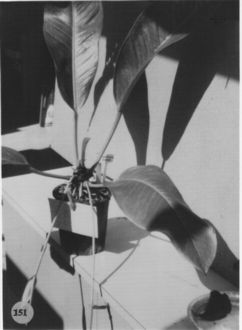
Epiphyte; stems short; roots pale green, in dense mass, ascending; cataphylls 8-11 cm long, coriaceous, drying brown, weathering into fibers and persisting at base of leaves.
LEAVES erect-spreading; petioles subterete, narrowly and bluntly
sulcate, 4-17 cm long, 4-7 mm diam.;
geniculum 1.5-2 cm long; blades elliptic to broadly elliptic to obovate
or oblanceolate, moderately thick, 22-54 cm long, 9.5-24 cm wide, abruptly
acuminate at apex, acute to obtuse at base; semiglossy above and below,
conspicuously punctate below; the midrib raised and ± flattened
(sometimes shallowly sulcate near base) above, convexly to acutely raised
below; primary lateral veins 15-18 per side, departing midrib at 45°
angle, sunken above, raised below, straight to collective vein, loop-connecting
with collective vein; lesser veins obscure; collective vein arising from
base, 3-6 mm from the margin.
INFLORESCENCE spreading-pendent, shorter or longer than leaves;
peduncle 9-34 cm long, 3-9 mm diam., sometimes tinged reddish-violet, conspicuously
ribbed beneath opening of spathe;
spathe coriaceous, yellow-green sometimes suffused with purple, lanceolate
or oblong, 6-12 cm long, 1.5-2.8 cm wide. shon-acuminate at apex, obtuse
to rounded at base, inserted at 40°-45° angle on peduncle; spadix
green, tinged red-violet in later stages, 13-36 cm long, 5-11 cm diam.
at base, 4-7 cm diam. at apex; flowers rhombic, 4-5 mm long, 3-3.5 mm wide,
the sides straight to weakly sigmoid; 4÷8 flowers visible in the principal
spiral, 6-10 flowers visible per alternate spiral; tepals matte, minutely
papillate, lateral tepals 2.5-3.5 mm wide, the inner margin ± straight;
pistil emergent but not raised, pale red-violet; stigma greenish, linear,
not conspicuously open; stamens emerging rapidly throughout, anthers barely
visible at edge of pistil, soon retracting leaving only sparse amount of
white pollen.
INFRUCTESCENCE with spadix to 48 cm long, berries pale red,
to faintly lavender or grayish-white, flattened at apex (depressed around
style), 4-5 mm long, 5-7 mm wide (direction of axis), 4.5-5 mm wide (perpendicular
to axis); seeds 3-4, greenish-while, 1.6-3 mm long, 1.3-2.1 mm wide, 1.2-1.5
mm thick; mesocarp juicy, gelatinous, translucent. Figs. 151
and 154.
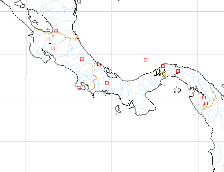
The species is known from Nicaragua to Panama from sea level to 1,400 m elevation
in wetter parts of tropical moist forest and in premontane wet, tropical wet,
premontane rain, and lower montane wet forest life /ones. In Costa Rica, the
species is widespread on the Atlantic slope and rare on the Pacific slope. In
Panama, the species is most abundant on the Atlantic slope but occurs also on
the Pacific slope near the Continental Divide.
Anthurium ramonense is most closely related to A.
paludosum, A. durandii, A.
alatipedunculatum and A. acutangulum,
which all share similar retracting stamens and densely punctate lower blade
surfaces. Anthurium ramonense can be distinguished by a combination of
its proportionally shorter, stoutcr petioles, generally larger blades and long,
tapered, generally stout inflorescence. Anthurium paludosum differs in
having thick, nondilacerating, persisting cataphylls and proportionally narrower,
usually smaller, con-colorous leaves with a conspicuous whitish-green midrib.
Anthurium durandii differs in having proportionally longer petioles and
in being geographically isolated in southwestern Costa Rica. Anthurium alatipedunculatum
differs in having an alate peduncle and a 3-sided petiole. Anthurium ramonense
is most easily confused with A. acutangulum because both share similar
features including thin, dilacerating, promptly deciduous cataphylls and long
inflorescences. Anthurium acutangulum differs, however, in having smaller,
typically elliptic blades and a proportionally longer, more slender petiole.
The petiole ranges from equally as long as the blade to one third as long as
the blade in A. acutangulum, whereas the petiole of A. ramonense
ranges from one sixth to one third as long as the blade. The spadix of A.
ramonense is also proportionally longer and stouter than that of A. acutangulum.
Anthurium ramonense is a member of section Porphyrochitonium.
Engler (1905) mentioned the affinity of A ramonense with A. filiforme
Engler of Colombia. This is perhaps another species in the complex but it is
inadequately known at present.
 |
 |
Map of Mesoamerican specimens with coordinates
Costa Rica : Monteverde Reserve, 1700 m, 10.19.5N 84.47.35W, 6 Aug 1988,
Hayworth 302 (WIS).
Costa Rica Alajuela: 10.12.53N 84.36.28W, 3 mayo 1987, Gerardo Herrera
Ch. 614 (MO).
Costa Rica Alajuela:, , Thomas B. Croat 46921 (MO).
Costa Rica Alajuela: 100 m, 10.52N 84.58W, 18 November 1987, Gerardo
Herrera 1334 (MO).
Costa Rica Alajuela: 600 m, 10.43.30N 85.00.30W, 14 July 1988, Gerardo
Herrera 2093 (MO).
Costa Rica Alajuela: 900 m, 10.18N 84.45W, 11 December 1987, William
Haber & Erick Bello 7870 (MO).
Costa Rica Alajuela: 1025-1100 m, 10.10.40N 84.34.10W, 3 September
1996, Thomas B. Croat 78880 (INB, MO, WU).
Costa Rica Cartago: 4000 m,, 02 Aug 1972, Taylor & Taylor 11463
(NY).
Costa Rica Cartago: Valle del Reventazón, 1115 m, 09.49.10N
83.27.30W, 10 October 1992, Priscila Campos 44 (CR).
Costa Rica Guanacaste: 1000 m, 10.24N 84.51W, 1 June 1987, William
Haber & Erick Bello 7192 (MO).
Costa Rica Guanacaste: Cordillera de Tilarán, 1000 m, 10.22N
84.51W, 10 November 1990, William Haber & Chris Ivey 10144 (CR).
Costa Rica Heredia: Río Sarapiquí, 100 m,, 4 Feb 1983,
Garwood et al. 1071 (BM)
Costa Rica Heredia: 700-950 m, 10.17.30N 84.04.30W, 9 April 1986, Michael
H. Grayum 6942 (MO).
Costa Rica Heredia: 100 m.,, 13 Feb. 1981, Folsom 8925 (CAS).
Costa Rica Heredia: La Selva, 100 m,, 5 Dec 1982, McDowell 1058A (NY).
Costa Rica Heredia: Finca La Selva, 100 m,, , Jacobs 2673 (DUKE).
Costa Rica Limn: 5 m, 10.43N 83.40W, 25 Jan 1986, Warren Douglas Stevens
24017 (MO).
Costa Rica Limn: 10-40 m, 10.40N 83.40W, 13-14 Sep 1986, Warren Douglas
Stevens 24358 (MO).
Costa Rica Limn: 40-100 m, 10.40N 83.40W, 13 March 1987, W.D. Stevens,
G. Herrera & O.M. Montiel 24767 (MO).
Costa Rica Limn: 20-170 m, 10.41N 83.38W, 15-20 Sep 1986, Warren Douglas
Stevens 24471 (MO).
Costa Rica Limn: 1-4 m, 10.49N 83.37W, 20 March 1987, W.D. Stevens,
G. Herrera & O.M. Montiel 25171 (MO).
Costa Rica Limn: 20-25 m, 09.34N 82.39W, 17 Nov 1984, Michael Grayum,
Gerardo Herrera & Felipe Chavarría 4448 (MO).
Costa Rica Limn:, 1988, M.B.G. 811900 (MO).
Costa Rica Limn: 150 m, 9.30.10N 82.57.50W, 24 June 1989, Gerardo
Herrera 2950 (MO).
Costa Rica Limn: 1-5 m, 10.47.40N 8.35.30W, 12 Sep 1986, Gerrit Davidse
& Gerardo Herrera 30864 (MO).
Costa Rica Limn: 10-120 m, 10.39.00N 83.40.40W, 15-16 Sep 1986, Gerrit
Davidse & Gerardo Herrera 31255 (MO).
Costa Rica Limn: 10-80 m, 10.40.30N 8.39.30W, 17-18 Sep 1986, Gerrit
Davidse & Gerardo Herrera 31341 (MO).
Costa Rica Limn: 10-80 m, 10.40.30N 8.39.30W, 17-18 Sep 1986, Gerrit
Davidse & Gerardo Herrera 31464 (MO).
Costa Rica Limn: 40 m, 10.28N 83.34W, 15 March 1988, Rafael Robles
1737 (MO).
Costa Rica Limn: 30 m, 10.22N 83.31W, 9 December 1988, Rafael Robles
2249 (MO).
Costa Rica Puntarenas: Reserva Biológica Monteverde, 1300 m,
10.16N 84.22W, 4 May 1991, Bello et al. 2716 (MO, CR).
Costa Rica Puntarenas: 1300 m, 10.18N 84.49W, 10 June 1985, Michael
H. Grayum 5419 (MO).
Costa Rica Puntarenas: 1000 m, 10.20N 84.50W, 9 MAY 1986, William A.
Haber ex Eric Bello C. & L. Lierheimer 4975 (MO).
Costa Rica Puntarenas: 0 m, 8.27N 83.33W, 16 June 1988, C. Kernan &
P. Phillips 581 (MO).
Costa Rica Puntarenas: Monteverde Reserve, 1500-1550 m, 10.18N 84.48W,
4 Apr 1993, Ingram & Ferrell-Ingram 1795 (MO).
Costa Rica Puntarenas:, 29 August 1985, William A. Haber 2437 (MO).
Costa Rica Puntarenas: 1450 m, 10.20N 84.50W, 5 JAN 1986, William A.
Haber 4067 (MO).
Costa Rica Puntarenas: 1450 m, 10.20N 84.50W, 5 JAN 1986, William A.
Haber 4070 (MO).
Costa Rica Puntarenas: 1400 m, 10.20N 84.50W, 15 MAY 1986, William
A. Haber ex Eric Bello C. & L. Lierheimer 4951 (MO).
Costa Rica Puntarenas: 1100-1200 m, 9.04.30N 83.05.00W, 29 Mar 1984,
Gerrit Davidse & G. Herrera Ch. 26279 (MO).
Costa Rica Puntarenas: R.B. Monteverde; Cordillera de Tilarán,
1300 m, 10.16N 84.22W, 4 May 1991, Erick Bello, Eladio & Roy Cruz 2721
(CR).
Costa Rica Puntarenas: Cordillera de Tilarán, 1100 m, 10.16.20N
84.49.30W, 20 January 1993, Zobeida Fuentes 138 (CR).
Costa Rica San José: 1100-1200 m, 10.04N 83.58W, 23 Jan 1983, G. Davidse
et al. 23196 (MO).
Nicaragua Río San Juan: 5m m,, 01 Dec. 1982, Araquistain, M. 3365 (MO).
Nicaragua Río San Juan:, 04 Dec. 1982, Araquistain, M. 3421 (MO).
Nicaragua Río San Juan: Municipio El Castillo, 11.08N 84.39W, 15 Enero
1995, Ricardo Rueda, Blas Hernández y Edith Palma 2865 (MO).
Nicaragua Río San Juan: 11.02N 083.48W, 29 Julio 1996, Ricardo Rueda,
Indiana Coronado y Norlan Tercero 4650 (MO, WU).
Nicaragua Río San Juan: 11.07N 084.12W, 15 Febrero 1997, Ricardo Rueda,
Indiana Coronado, Oscar Aráuz & Franklin Flores 5863 (MO).
Nicaragua Río San Juan: 11.09N 084.11W, 17 Febrero 1997, Ricardo Rueda,
Indiana Coronado, Oscar Aráuz & Franklin Flores 5983 (MO).
Nicaragua Río San Juan: 11.09N 084.11W, 17 Febrero 1997, Ricardo Rueda,
Indiana Coronado, Oscar Aráuz & Franklin Flores 6025 (MO).
Nicaragua Río San Juan: 11.09N 084.11W, 19 Febrero 1997, Ricardo Rueda,
Indiana Coronado, Oscar Aráuz & Franklin Flores 6074 (MO).
Nicaragua Río San Juan: 11.09N 084.11W, 20 Febrero 1997, Ricardo Rueda,
Indiana Coronado, Oscar Aráuz & Franklin Flores 6125 (MO).
Nicaragua Río San Juan: 11.09N 084.11W, 20 Febrero 1997, Ricardo Rueda,
Indiana Coronado, Oscar Aráuz & Franklin Flores 6154 .
Nicaragua Río San Juan: 11.02N 083.48W, 29 Julio 1996, Ricardo Rueda,
Indiana Coronado y Norlan Tercero 4637-a (MO).
Nicaragua Zelaya: 11.31N 84.19W, 24 Febrero 1994, Ricardo Rueda, Blas
Hernández e Indiana Coronado 3497 (MO).
Nicaragua Zelaya: 11.31N 84.45W, 27 Febrero 1994, Ricardo Rueda, Blas
Hernández e Indiana Coronado 3663 (MO).
Nicaragua Zelaya: 180-200 m, 11.40N 84.26W, 11-12 February 1978, W.D.
Stevens 6309 (MO).
Panama Bocas del Toro: 910 m, 8.44N 82.17W, 12 March 1985, T.B. Croat
& M.H. Grayum 60445 (MO).
Panama Bocas del Toro: 120 m, 08.57N 08.56W, 29 March 1993, Thomas
B. Croat 74935 (MO).
Panama Cocl: 200 m, 9.47N 80.28W, 9 Dec. 1983, H.W. Churchill, A.
Lier, W.S. Armbruster & A. Herzig 3986 (MO).
Panama Coln: 50 m, 9.30N 79.39W, 6 May 1984, H.W. Churchill 5118 (MO).
Panama Darien: 110 m, 08.01N 77.44W, 26 July 1994, Thomas B. Croat
& Guanghua Zhu 77105 (AAU, MO, TEX).
Panama Darien: 70-270 m, 8.01N 77.44W, 08 October 1987, B. Hammel H.
Herrera & G. de Nevers 16131 (MO).
Panama Darien: 800-1000 m, 07.45N 77.40W, 22 August 1987, Gordon McPherson
11535 (MO).
Panama Darien: 900-1250 m, 07.45N 77.40W, 26 August 1987, Gordon McPherson
11601 (MO).
Panama Darien: 70-270 m, 8.01N 77.44W, 08 October 1987, B. Hammel H.
Herrera & G. de Nevers 16113 (MO).
Panama Darien: 600-800 m, 8.04N 77.16W, 21 Oct 1987, B. Hammel G. de
Nevers, H. Cuadros & H. Herrera 16403 (MO).
Panama Panamá: 1800 ft,, 31 Jan 1979, Hammel 6016 (MO).
Panama Panamá: 200 m, 09.15N 79.00W, 17 December 1987, Gordon McPherson
11893 (MO).
Panama Panamá: 300 m, 9.16N 78.57W, 26 Oct. 1983, H.W. Churchill 3811
(MO).
Panama San Blas: 550 m, 9.44N 78.68W, 14 March 1985, Thomas B. Croat
60489 (MO).
Panama San Blas: 350 m, 9.19N 78.15W, 12 March 1985, Greg de Nevers
& H. Herrera 5124 (MO).
Panama San Blas: 350 m, 9.19N 78.55W, 8 March 1986, Greg de Nevers
& Heraclio Herrera 7267 (MO).
Panama San Blas: 350-350 m, 9.19N 78.55W, 4 Nov. 1984, Greg de Nevers
& H. Herrera 4176 (MO).
Panama San Blas: 350 m, 9.19N 78.55W, 6 Nov. 1984, Gred de Nevers 4199
(MO).
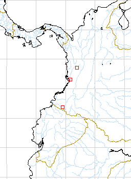
Map of South American Specimens with coordinates
Colombia Antioquia: 180 m,, 1 May 1987, Fonnegra et al. 2040 (HUA).
Colombia Antioquia: 150 - 200 m,, 30 Apr. 1987, Fonnegra et al. 1973
(HUA).
Colombia Antioquia: 500-600 m,, 4 Feb 1972, D.D. SOEJARTO, J.SANTA
& E.FENNEGRA 3204 (HUA).
Colombia Choco: 100 m, 5.13.30N 76.21.30W, 15 March 1984, Thomas B.
Croat 57470 (CHOCO, COL, MO).
Colombia Choco: Parque Natural Nal. Los Katyos, 70 - 120 m,, 1976,
Leon, H. 680 (COL).
Colombia Narino: La Planada, 1700 m, 1.06N 77.53W, 10 March 1990, Thomas
B. Croat 43304A (MO).
Colombia Valle del Cauca: Río Cajambre, 0-5 m,, 17 May 1944,
Cuatrecasas 17727 (F,US).
Colombia Valle del Cauca: 50 m, 03.59N 77.02W, 31 March 1986, Al Gentry,
E. Zardini & M. Monsalve 53875 (MO).