


Anthurium scherzerianum Schott,
Oesterr. Bot. Wochenbl. 7: 53. 1857. TYPE: Guatemala, Scherzer s. n. (B, holotype (2 sheets); BP, isotype).
Epiphytic or terrestrial; stems very short, roots numerous, thin; cataphylls thick, to 1.5 cm long, caudate at apex, drying brown, persisting as fibers.
LEAVES spreading; petioles terete, 4-20 cm long, 1-3 mm diam.;
gcniculum 4-7 mm long; blades moderately thick, linear to elliptic or lanceolate,
5-26 cm long, 1.5-6.5 cm wide, narrowly acuminate at apex, obtuse to cuneate
at base; upper surface semiglossy, the lower surface matte, both surfaces
densely punctate; the midrib acutely raised above, sunken at apex;
prominulous below; primary lateral veins 8-11 per side, departing midrib
at 45° angle, nearly obscure above and below, loop-connecting to collective
vein, lesser veins obscure; collective vein arising from near the base
or one of the lowermost primary lateral veins, 1-3 mm from the margin.
INFLORESCENCE erect, equalling or longer than leaves; the peduncle
14-52 cm long, ca. 2 mm diam.; spathe moderately thick, bright red-orange
(B & K Red 7/2.5), elliptic to ovate, 3.7-12 cm long, 2.4-6 cm wide,
abruptly short-acuminate at apex, cordate at base (the lobes sometimes
overlapping); spadix pale orange to red, 2-8 cm long, ca. 4 mm diam. midway,
tapered at apex and usually coiled; flowers square, 2 mm in both directions,
the sides straight to ± sigmoid, 2-3 flowers visible in the principal
spiral, 5-6 flowers visible in the alternate spiral;
tepals glossy, sparsely and minutely papillate, lateral lepals ca.
1.3 mm long; pistil weakly emergent, somewhat translucent; stigma linear,
0.4-0.6 mm long; stamens emerging from base, the first lateral preceding
second by 2-3 spirals, the laterals emerged well above midway before alternates
emerge, exserted on flattened, short filaments, ca. 3 mm long, 0.5 mm wide;
anthers white, held at edge of tepals, ca. 0.3 mm long, 0.5-0.7 mm wide;
thecae cllipsoid, slightly divaricate; pollen white.
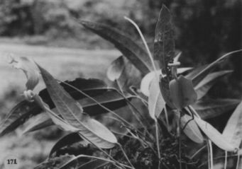
INFRUCTESCENCE with orange to red berries. Fig. 171.
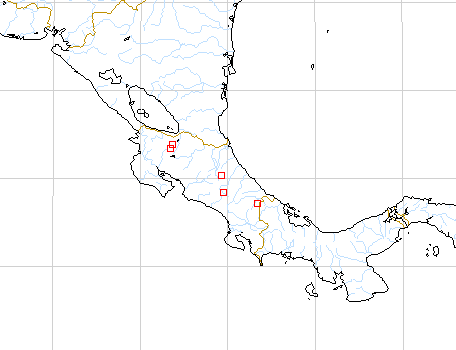
The species is found in Costa Rica at elevations of 1,300 to 2,100 m
in premontane rain, lower montane rain, and montane rain forest life zones
on the Atlantic slope of the Cordillera Central and the Cordillera de Talamanca.
It has been collected most commonly in the Tapanti and La Hondura areas.
Anthurium scherzerianum is a member of section Porphyrochitonium
and is easily recognized by the large, showy, bright orange or red-orange
to red spathe, and coiled spadix. The species is now commonly cultivated
throughout the world and about 40 different forms are recognized in cultivation.
The species has no close relatives.
The type of A. scherzerianum was believed to have been collected
in Guatemala; however since that time no other collections have been seen
from that country. So far the species has been found only in Costa Rica,
where it is plentiful, and it is likely that the type was collected there.
 |
Map of Mesoamerican specimens with coordinates
Costa Rica Alajuela: 700 m, 10.49N 84.57W, 13 November 1987, Gerardo
Herrera 1238 (MO).
Costa Rica Alajuela: 700 m, 10.49N 84.57W, 22 April 1988, Gerardo Herrera
1863 (MO).
Costa Rica Alajuela: 700 m, 10.43.15N 85.00.20W, 8 July 1988, Gerardo
Herrera 2017 (MO).
Costa Rica Alajuela: Cordillera de Guanacaste, 700-1000 m, 10.44N 85.03W,
27 August 1994, William Haber & W. Zuchowski 11835 (CR, INB). Costa
Rica Cartago: 1650 m, 09.42N 83.47W, 11 Aug 1984, Michael H. Grayum, Brian
Jacobs & Pam Sleeper 3765 (MO).
Costa Rica Cartago: Tapantí, 1200 m,, 11 July 1987, Berrocal
193 (WIS).
Costa Rica Cartago: P.N. Tapantí; Valle del Reventazón,
1350 m, 09.44.05N 83.46.42W, 21 July 1994, J.F. Morales, Lépiz &
J. González 3048 (CR).
Costa Rica Cartago: P.N. Tapantí; Valle del Reventazón,
1300 m, 09.45.20N 83.47.00W, 2 June 1994, Eduardo Lépiz, J.F. Morales,
G. Carnevali & S. Troyo 317 (CR).
Costa Rica Cartago: P.N. Tapantí; Valle del Reventazón,
1300 m, 09.45.20N 83.47.00W, 20 July 1994, Eduardo Lépiz 486 (CR,
MO).
Costa Rica Guanacaste: Z.P. Tenorio; Cordillera de Tilarán,
1050 m, 10.36.40N 84.59.45W, 16 December 1992, Gladys Rodriguez 67 (CR).
Costa Rica Heredia: 1200-1400 m, 10.15.30N 84.05.00W, 13 Nov 1986,
Michael Grayum & Gerardo Herrera 7855 (MO).
Costa Rica Heredia: Finca La Selva, 100 m,, , Taylor & Skotak 4834
(DUKE).
Costa Rica Limn: 810 m, 9.27.30N 83.00.00W, 25 July 1989, Abelardo
Chacón 286 (MO).
Costa Rica Limn: Reserva Indigena Talamanca, 700-900 m, 09.27.00N
82.59.30W, 9 July 1989, Hammel et al. 17624 (MO).
Costa Rica Limn: Canton de Guapiles, 1200 m, 10.06.20N 83.50.40W,
21 Feb 1990, Herrera 3770 (CR, MO).
Costa Rica Limn: 1190 m, 9.23.10N 83.00.25W, 27 July 1989, Gerardo
Herrera 3370 (MO).
Costa Rica Limn: 850 m, 9.47.40N 83.06.30W, 11 April 1989, Rafael
Robles & Abelardo Chacón 2747 (MO).
Costa Rica Limn: 1680 m, 09.14718"N 83.10845"W, 20 Apr 1989, Herrera
& Chacon 2681 (CR, MO).
Costa Rica Limn: P.N. Cordillera de Talamanca; Cordillera de Talamanca,
1300 m, 09.24.15N 83.05.15W, 6 March 1992, Gerardo Herrera 5181 (CR, MO).