![]()
![]()
![]()
Philodendron advena Schott,
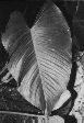
Oesterr. Bot. Wochenbl. 5: 289. 1855. TYPE: Mexico. Exact location uncertain, described from living material, Schott s.n. (lectotype, L 900230 (89889152); here designated). Figures 37--40, 73.
Philodendron subovatum Schott, Osterr. Bot. Wochenbl. 5: 289. 1855. TYPE: Western Mexico: a cultivated collection prepared by Schott. (holotype, W, now destroyed). Field Museum Photo 29864 [neotype here designated; duplicate photo at MO]. Philodendron monticola Matuda, Madroño 10: 170. 1950. TYPE: Mexico. Chiapas: Sierra Madre, Pacific slope, Colonia San Juan Panamá, 50 km E of Escuintla, 1600 m, Matuda 18169 (holotype, MEXU; isotypes, DS, NY, UCLA). Philodendron jamapanum G. S. Bunting, Gentes Herb. 9: 336, fig. 242. 1965. TYPE: Mexico. Veracruz: Coscomatepec-Huatusco, Route 155 at Rió Jamapa, Moore & Bunting 8872 (holotype, BH).
Terrestrial, epilithic,
or hemiepiphytic; stem appressed-climbing, to 2 m long, sap brownish orange;
internodes weakly glossy, 2--4 cm long, 1.5--2.5(5.5) cm diam., longer than
broad, sometimes obtusely flattened on one side, medium green to gray-green,
drying brown to yellow-brown, epidermis smooth to closely fissured; roots few
per node, drying dark brown to yellow-brown, epidermis sometimes flaking; cataphylls
subcoriaceous, 7.7--45 cm long, sharply D-shaped to sharply 2-ribbed, rarely
weakly 2-ribbed, light green to whitish, tinged reddish, generally deciduous
intact, weakly emarginate at apex, margins clear.
LEAVES erect-spreading to spreading with blades pendent; petioles
30--45(65) cm long, 7--18 mm diam., erect-spreading, subterete to D-shaped,
somewhat spongy to moderately firm, obtusely flattened adaxially, sheath 3--11
cm long; blades ovate-cordate to sagittate, subcoriaceous, moderately
bicolorous, gradually acuminate at apex, cordate at base, (32)41--47(64) cm
long, 16.5--40 cm wide (1.2--2.5 times longer than wide; 1--1.5 times longer
than petioles), margins hyaline, upper surface dark green, drying dark brown
to blackened, sometimes yellow-green, lower surface slightly more glossy, paler,
drying yellow-brown to reddish brown, sometimes greenish brown; anterior lobe
20.5--53 cm long, 12--40 cm wide (3.4--3.8 times longer than posterior lobes);
posterior lobes rounded, 6--14(20) cm long, 5.4--15(20) cm wide, directed toward
base; sinus more or less parabolic to V-shaped or spathulate, 8--15 cm deep;
midrib broadly convex to flat, slightly paler than surface above, convex and
slightly paler below; basal veins 3--6 per side, with 0--1(2) free to base,
coalesced (0.4)1.3--4(8.5) cm; posterior rib not naked or obscurely naked to
1 cm at base; primary lateral veins (3)4-6 per side, departing midrib at a (45)50--60(80)E
angle, straight or weakly arcuate to the margins, flat to sunken and paler than
surface above, convex below; minor veins weakly raised, moderately visible,
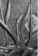
arising from both the midrib and primary lateral veins. INFLORESCENCES spreading-pendent,
1--2(4) per axil; peduncle 5--13.5(17) cm long, 7--11 mm diam.; spathe
coriaceous, (6.5)12--19 cm long, ((0.7)1.4--2.4) times longer than peduncle),
weakly or not at all constricted above the tube, acuminate, usually greenish
throughout, broadest at or below the middle; spathe blade greenish white outside,
spathe red to maroon or greenish white, glossy inside; spathe tube sometimes
reddish outside, 5--8 cm long, 2.5--3.5(5) cm diam., red to maroon or dark violet-purple,
pale-lineate, glossy inside; spadix stipitate to 4 mm long; clavate to
cylindrical, bluntly pointed at apex, 11.5--14 cm long, broadest at the middle
or more or less uniform throughout; pistillate portion 3.3--6.9 cm long, 1.2--2.7
mm diam. at middle, narrowed somewhat at both ends; staminate portion 5--9.2
cm long; fertile staminate portion tapered to cylindrical or clavate, usually
longer than pistillate portion, 11--14 mm diam. at base, 8--15 mm diam. at middle,
5--7 mm diam. ca. 1 cm from apex, broadest below middle, equal in length to
pistillate portion, narrower than pistillate and sterile portions; sterile staminate
portion, 11--30 mm diam., usually broader than pistillate porton at anthesis;
pistils 1.7--8.5 mm long, 1.3--2.9 mm diam., ovary (5)6--8-locular, with basal
to sub-basal placentation; ovules 1--4 per locule, arranged digitately in translucent
ovule sac, 0.2--0.6(1.5) mm long, equal in length to funicle; funicle adnate
to lower part of partition, style 0.9-3 mm long, similar to style type B; style
apex flat; stigma discoid to subdiscoid; thecae cylindrical to elliptical, 0.5
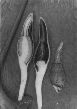
mm wide, contiguous. INFRUCTESCENCE with spathe green outside, dark purple-violet
inside, 11.5--14 cm long; berries white to yellowish; seeds 1(3--4) per locule,
oblong-ellipsoid, sometimes obovoid, 1.7--2.2 mm long, 0.7--1.8 mm diam., with
clear longitudinal and faint latitudinal striations and speckled with shiny,
silver raphide cells; funicular scar knob-like, clear, thicker than the seed
body.
Flowering specimens of Philodendron advena have been collected in post-anthesis condition virtually throughout the entire year. Mature fruits have been collected less consistently with July and August the only consecutive months without fruits reported.
Philodendron advena ranges from Central Mexico (Veracruz) along the Atlantic slope to Chiapas and then along both the Pacific and Atlantic slopes to southern Guatemala (Santa Rosa and Chiquimula Departments). It occurs at 70 to 2500 (mostly above 1000) m elevation in a wide variety of vegetation types, including "Selva Alta Perennifolia," "Bosque Caducifolia," "Selva Mediana Subperennifolia," and "Bosque Caducifolia."
Philodendron advena is a member of Philodendron sect. Calostigma subsect. Macrobelium ser. Macrobelium. The species is distinguished by internodes longer than broad, its two-ribbed, generally deciduous cataphylls, terete to obtusely flattened, somewhat spongy petioles (about as long as the blades), and by its generally coriaceous, ovate-cordate, usually dark brown to blackened-dried to somewhat sagittate-lobed blades with rounded lobes with usually four to six primary lateral veins, and usually one to two green inflorescences with the inner surface reddish to purplish.
Material from the Pacific slope in Chiapas State of Mexico and in adjacent Guatemala often dries somewhat more greenish. This was described by Matuda as P. monticola Matuda. Considering the variability in the species, that taxon is not warranted. Though not closely related to P. purulhense Croat, P. advena is perhaps most easily confused with that species, because both may have similar ovate, black-drying leaves. Philodendron purulhense differs from P. advena in its persistent cataphylls, a more or less elliptic spathe scarcely constricted above the tube, and ovaries with axile placentation and 13--20 ovules per locule.
Philodendron advena is probably mostly closely related to
the equally ecologically versatile P. sagittifolium, which occurs throughout much of its range. Philodendron sagittifolium is distinguished by having usually longer, more prominently sagittate blades (averaging 1.5--3 times longer than broad) which dry typically reddish brown rather than blackened. In contrast, P. advena has blades averaging 1.5 times longer than broad (ranging from 1.3--1.8 times longer). Both P. advena and P. sagittifolium have five to eight locules per pistil with up to three, more or less basal ovules (or they have the funicle adnate to the lower part of the axillary wall but extending down to the base).
Two Oaxaca collections are noteworthy. Moore & Bunting 8891 from above Valle Nacional in the Serranía de Juarez of Oaxaca dried greenish brown on the lower surface and gray-brown above. Also unusual is Moore & Bunting 8919 (collected near 8891) which dried reddish brown. This collection was discussed as possibly distinct by Bunting (1965). Aside from the color of the blades upon drying, there is nothing else out of the ordinary with the collection (see Fig. 235 in Bunting, 1965).
 |
 |
 |
 |
 |
Additional specimens examined.
GUATEMALA. Alta Verapaz: near Chirriacté, on the Petén Highway, ca. 900 m, Standley 92192 (F); ca. 6 km NE of Panzós, 800 m, Croat 41689 (MO); 7 mi. up the road to Oxec, 700 m, 41651 (MO); Finca Argentina, 15 mi. W of Telemán, 550--650 m, 41571 (MO); 2--4 mi. E of Tamahú, 9--11 mi. E of Hwy. CA-14 to Cobán, 700--800 m, 41498 (MO); near Tactic, ca. 1500 m, Standley 70495 (F); near Tactic, above Río Frío, 1400--1500 m, 90484 (F). Chiquimula: Cerro Tixixí, 3--5 mi. N of Jocotán, 500--1500 m, Steyermark 31563 (F). Quezaltenango: in reserve INDE "Santa María", km 99, 14E45'N, 91E32'W, Croat & Hannon 63430 (K, MO, US, USCG); El Pocito, S of San Martín Chile Verde, on road to Colomba, ca. 2200 m, Standley 85039 (F), 85093 (F); between San Martín Chile Verde and Colomba, above Mujuliá, ca. 1800 m, 85723 (F), 85561 (F); between Finca Pirineos and Finca Patzulín, 1200--1400 m, 86875 (F); Río Samalá, near Santa María de Jesús, 1500--1650 m, 84571 (F), 84669 (F). San Marcos: Canjulá--La Unión Juárez, near SE portion of Volcán Tacaná, 2000--3000 m, Steyermark 36407 (F); Volcán Tajumulco, 1400--1700 m, 37391 (F); ca. 3.3 mi. above Finca Armenia, above San Rafael, 1600 m, Croat 40963 (MO, NY); San Rafael--Pie de la Cuesta--Palo Gordo, near Aldea Fraternidad, 1800--2400 m, Williams et al. 26014 (F, NY). Santa Rosa: Cenaguilla, 4000 ft., Heyde & Lux 4281 (G, NY, US). Zacapa: summit of Sierra de las Minas, vic. of Finca Alejandria, 2500 m, Steyermark 29855 (F); Río Lima, Sierra de las Minas, below Finca Alejandria, 2000 m, 30026 (F). MEXICO. Chiapas: Lagos de Montebello, 3 mi. W of Dos Lagunas, 1460 m, Croat 46636 (MEXU, MO), 46655 (MO); ca. 6 mi. NW of Pueblo Nuevo Solistahuacán, vic. km 99, 1900--1950 m, 17E07'N, 92E52'W, Croat & Hannon 65193 (MEXU, MO); 8 mi. NW of Pueblo Nuevo Solistahuacán, 1900--1950 m, Croat 46429 (MEXU, MO), 46430 (MEXU, MO); Ixtapa--Pichucalco, 47777 (B, K, MO); Bochil--Pichucalco, 3.4 km W of El Anepo, 1860 m, Croat 78610 (CHIP, CM, K, MO, NY); San Cristóbal--Palenque, 97 km NE of San Cristóbal, 1130 m, 17E27'N, 92E04'W, Hammel et al. 15624 (MO); Palenque--Bonampak, 89-90 mi. SW of Palenque, 350--370 m, Croat 40221 (MO); San Juan Panamá, Escuintla, 1800 m, Matuda 18488 (MEXU, NY); Cascada, Siltepec, 1800 m, 19643 (MEXU); Paso Pashital, Sierra Madre de Chiapas, 1800 m, 37585 (MEXU); Cerro Brujo, Ocozozoautla de Espinosa, MacDougall 415 (MEXU); ca. 6 mi. SW of Motozintla de Mendoza, ca. 1850 m, Croat 47246 (MO); 26--30 mi. N of Motozintla de Mendoza, 9.5--4.5 mi. S of Siltepec, 1000--1300 m, 47462 (MO); Ojo de Agua, Soconusco, Nakamura 38 (DS); San Fernando--Moravillas, 4--66 mi. NW of San Fernando, 840--940 m, 16E53'N, 93E16'W, Croat & Hannon 65006 (B, MEXU, MO, US); Mpio. Angel Albino Corzo, above Finca Cuxtepec, 1380 m, Breedlove 52073 (DS); Mpio. Berriozábal, 13 km N of Berriozábal, 900 m, 35438 (DS); 16 km NW of Rizo de Oro, 1600 m, Breedlove & Smith 31382 (DS); Mpio. Ocosingo, Laguna Ocotal Grande, 3300 ft., Breedlove 15683 (F, MICH); 5 km SE of Crucero Corozal, 250 m, Martínez 12171 (MEXU); Mpio. Rayón, Selva Negra, 10 km above Rayón Mezcalapa, along road to Jitotol, 1700 m, Breedlove 23291 (DS); Mpio. Union Juárez, Volcán Tacaná, above Talquian, 2200 m, Breedlove & Almeda 47712 (CAS); Mpio. Villa Corzo, E base of Cerro Tres Picos, near Cerro Bola, 1500 m, 16E10'N, 93E15'W, Breedlove & Thorne 30193 (DS). Oaxaca: Sierra de Juárez, Highway 175, 6--14 mi. from bridge at Valle Nacional, ca. 580 m, Moore & Bunting 8891 (BH); Vista Hermosa, 17.9 mi. from bridge at Valle Nacional on road to Oaxaca, 8919 (BH); 660 m, Croat 78721 (CHIP, MO); 4.3--6 mi. above bridge at Valle Nacional, 705 m, 17E44'N, 96E19'W, Croat & Hannon 65549 (CM, MEXU, MO, NY, US); 14 mi. W of Valle Nacional, 1210 m, Croat 39783 (MEXU, MO), 39796 (MO); 21.5 mi. above Valle Nacional, 1660--1670 m, 48108 (MO); Teotitlán del Camino-Chilchotla, 2.2 mi. beyond turnoff to Huautla de Jiménez, 2270 m, 48335 (CM, MO); 3.8 mi. past turnoff to Huautla de Jiménez, 2265 m, 48369 (MO); Ixtlán, Río Soyolapan watershed, 765--805 m, 17E37'N, 96E17'W, Boyle et al. 3943 (MO). Tabasco: Teapa-Tacotalpa, 3.1 mi. E of Teapa, ca. 0.25 mi. S of highway, 150 m, 17E33'N, 92E59'W, Croat & Hannon 65376 (MO); Mpio. Teapa, 7 km SE of Teapa on road to Tacotalpa, Rancho San Enas, Sierra Madrugal, 70 m, 17E35'N, 92E50'W, Hammel & Morello 15519 (MO, NY); Río Puyacatengo, Sierra Madrigal, 7 km E of Teapa, trail from Centro Regional del Sureste of Universidad Autonoma Chapingo, 300 m, 18E32'N, 92E55'W, Schatz et al. 1178 (MO). Veracruz: Veracruz--Oaxaca, Uxpanapa, 150 m, 17E05'N, 84E35'W, Hammel & Merello 15563 (MO); above San Jose de Gracia, 1 mi. S of hwy. between Córdoba and Veracruz, 750 m, Croat 39618 (MO); Conejo-Huatusco, at km 45, barranca de Santa María, across hwy. from Hacienda El Mirador, Moore & Bunting 8856 (BH); ca. 1200 m, Croat 44013 (MO); Mendoza--Orizaba, Sierra San Cristóbal, Highway 150-D, ca. 3 km SW of Orizaba, 1260--1400 m, Croat 39549 (CM, MEXU, MO); Fortín-Huatusco, Highway 125, 300 m, 19E06'N, 97E02'W, Croat & Hannon 63107 (B, COL, CR, CM, F, G, INPA, K, LL, M, MO, NY, QCA, P, PMA, US, VEN); Acajete, 1750 m, Cházaro & Robles 3115 (WIS); Mpio. Coacoatzintla, 1300 m, Cházaro 1053 (F); Mpio. Ixhuacan, Río Ixhuacan, El Aguacate--Putlanalan, Puebla, 1500 m, Cházaro & Cházaro 4068 (MO, WIS); Mpio. Jalapa, 8 km NW of Consolapan, 1525 m, ca. 19E30'N, 96E59'W, Nee 29683 (MO, NY); Coapexpan, 1470 m, Young 35 (F, MO); Mpio. Tlanelhuayocan, Barranca del Pixquiac, Rancho Viejo--Ya Vega, 1650 m, Cházaro & Ramarillo 3895 (MO, WIS); Mpio. Yecuatla, Los Capulines, near Paz de Enríquez, ca. 8 km N of Chiconquiaco, 1400--1600 m, 19E47'N, 96E49'W, Taylor et al. 147 (F, MO, NY).