![]()
![]()
![]()
![]()
Philodendron platypetiolatum Madison,
Selbyana 2: 22.1977. TYPE: Ecuador. Los Ríos: Río Palenque Science Center, km 56 on road to Santo Domingo and Quevedo, 150--220 m, ca. 0E35'S, 79E22'W, Dodson 6638 (holotype, SEL; isotypes, MO, QCA, US). Figures 306--308.
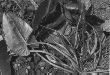
Hemiepiphytic; stem more or less scandent, loosely appressed-climbing, to 3 m long, semiglossy, sap clear, watery, sticky, leaf scars to 2 cm wide; internodes slender, 14--20 cm long, 1--2 cm diam., longer than broad, sometimes somewhat flattened on side above, semiglossy, green to grayish green, epidermis drying tannish brown, cracking, loosening and flaking; roots pale to brownish, less than 20 cm long, thin, 2 mm diam., smooth; cataphylls (6)10--17 cm long, sharply 2-ribbed, sharply and deeply sulcate with margins flared, pale to medium green, drying yellowish to olive-green, deciduous; petioles 15.5--56 cm
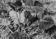
long, 3--9(12) mm diam., broadly flattened to markedly flattened and turned slightly upward adaxially, broadly convex abaxially, firm, medium to dark green, surface more or less unmarked; blades ovate-triangular to broadly ovate, subcoriaceous, semiglossy to glossy, weakly to moderately bicolorous, acuminate, sometimes long, narrowly acuminate at apex (the acumen tightly inrolled, 2--3 mm long), weakly cordate at base, 17--39 cm long, 12.7--29 cm wide (1--1.5 times longer than wide), (0.6--1.4 times longer than petiole), usually about equal in length to petiole; anterior lobe 15--34 cm long, 13--29 cm wide (2.4--4.5(5.2--5.4) times longer than posterior lobes); posterior lobes 4--10 cm long, 5--12 cm wide, broadly rounded to obtuse; sinus hippocrepiform, rarely arcuate with blade decurrent on petiole; midrib sunken or flat to broadly convex above, slightly paler than surface to concolorous above, bluntly low-triangular to convex below, paler than surface below; basal veins (2)3--4(5) per side, with 0--1 free to base, second and third coalesced 1--2 cm; posterior rib naked for 0--1 cm; primary lateral veins 3--5 per side, departing midrib at a 50--60E angle, straight to the margins, sunken to weakly sunken above, convex below; minor veins moderately indistinct, arising from both the midrib and primary lateral veins.
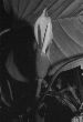
INFLORESCENCES 1(2) per axil; peduncle 5--20 cm long, 2--11 mm diam., subterete or bluntly 1--2-angled, pale green, semiglossy, unmarked; spathe semiglossy, (8)11--18 cm long (0.7--2(2.8) times longer than peduncle); spathe blade green or red outside, pale yellow-green (dark red in So. America), inside; spathe tube green to olive-green, usually tinged red or maroon outside, 4.5--7.5 cm long, tinged red or maroon inside; spadix sessile; weakly tapered, more or less acute at apex, 8--9.8 cm long, broadest at the base or more or less uniform throughout, constricted weakly between sterile and fertile staminate portions; pistillate portion pale greenish, cylindrical or weakly tapered toward the apex, 2.5(3.5) cm long, 9--11 mm diam. at apex, 10--13 mm diam. at middle, 10--13 mm wide at base; staminate portion 5.7--7.3 cm long; fertile staminate portion white, weakly tapered or cylindrical, 5--7 mm diam. at base, 4--5 mm diam. ca. 1 cm from apex, broadest at the base or more or less uniform, narrower than the pistillate portion, broader than or as broad as the sterile portion; sterile staminate portion as broad as or slightly narrower than the pistillate portion, 5--10 mm diam.; pistils (0.8)1.7--2.5 mm long, (0.6)0.9--1.4 mm diam., white; ovary (6)7--8-locular, (0.7)1.1--1.8 mm long, 0.8--1.2 mm diam., with sub-basal placentation; locules 0.7--1.5 mm long, 0.3 mm diam., ovule sac 0.8 mm long; ovules 3 per locule, 1-seriate, contained within translucent to transparent, gelatinous envelope, (0.2--0.3)0.4--0.5 mm long, longer than funicle; funicle 0.2--0.3 mm long, (can be pulled free to base), style (0.1)0.4--0.7 mm long, 0.6--0.8 mm diam., similar to style type B; style apex steeply sloping, sometimes with small medial depression; stigma subdiscoid to hemispheroid, somewhat cupullate, 0.7--0.9(1.3) mm diam., 0.2--0.3 mm high, covering entire style apex; the androecium prismatic, truncate, oblong, margins irregularly 4--6-sided, sometimes weakly scalloped; thecae cylindrical to oblong, 0.3--0.4 mm wide, more or less parallel to one another, sometimes more or less contiguous; sterile staminate flowers irregularly 4--6-sided or rounded, 0.9--1.5 mm long, 0.7--1.2 mm wide. INFRUCTESCENCE turning red outside; berries green (immature).
Flowering in Philodendron platypetiolatum occurs in the early rainy season, June and September, in Central America based on the few available flowering collections. Post-anthesis collections from Costa Rica and Panama are mainly from August through November, but also from March. Immature fruits have been collected only in January, February, and November. Ecuadorian populations have a similar phenology, but flowering collections have been made earlier, in March and April, with post-anthesis collections from March through August.
Philodendron platypetiolatum ranges from Nicaragua to Ecuador, from sea level to 1500 (though most collections are from below 400) m elevation, in Premontane wet forest, Tropical wet forest transition to Premontane wet forest, and Tropical wet forest life zones. This species has been collected at several localities in Chocó and Valle Departments; in Ecuador, it has only been collected at and near the type locality.
Philodendron platypetiolatum is a member of P. sect. Calostigma subsect. Macrobelium ser. Macrobelium. This species is characterized by its scandent habit, moderately long, slender internodes with tannish brown, frequently flaking epidermis, markedly flattened petioles about as long as the blade, and ovate-triangular to broadly ovate, weakly cordate blades. Though the spathes may be entirely green outside, they usually are heavily tinged with red or maroon outside and the tube within is likewise colored.
There are no other species in Cental America with which P. platypetiolatum might be confused. Madison compared this species to P. lechlerianum Schott, a species from Peru and Bolivia which has terete petioles.
In Panama, this species ranges along the Atlantic slope but may also occur on the Pacific slope near the Continental Divide. In Ecuador, it is restricted to the Pacific slope.
Ecuadorian specimens have blades that are more broadly ovate than those from Panama, but no other differences have been detected.
 |
 |
 |
Additional specimens examined.
COSTA RICA. Alajuela: Upala Road, 3 km NNE of Bijagua, 450 m, 10E45'N, 85E3'W, Burger & Baker 9890 (CR, F, MO, NY, SEL), 5 km S of Canalete, near Río Zapote, 100--200 m, 10E48'N, 85E2'W, Burger & Baker 9972 (F, MO), Dos Ríos, 5 km S de Brasilia, Río Pizote, 500 m, 10E55'N, 85E20'W, Herrera 1001 (CR, MO, SAR); 17 km NW of San Ramón, 785 m, 10E14'14"N, 84E33'W, Croat 68136 (F, MO); Bajo Rodríguez--La Tigra, vic. of La Tigra, 330 m, 10E22'N, 84E38'W, Croat 68205 (B, CM, G, M, MO, SAR, US); Monteverde Cloud Forest Nature Reserve, Río Peñas Blancas, 1250--1350 m, 9E17'N, 84E86'W, Burger et al. 10745 (F, MO); Vara Blanca--Puerto Viejo, 3 mi. N of San Miguel, 380 m, Croat 35666 (MO); Cañas--Upala, 13.8 km N of Bijagua, 100--150 m, Croat 36433 (MO); 4 km NNE of Bijagua, ca. 400 m, Croat 36269 (MO); slopes of Miravalles, above Bijagua, Gómez et al. 19066 (MO); Naranjo--Aguas Zarcas, along Hwy. 15, 8.5 km NE of Villa Quesada, 600 m, Croat 46973 (CR, MO). Heredia: "Starkey Road", 4.5 km SE of bridge at Puerto Viejo, ca. 50 m, 10E26'N, 83E58'W, Stevens 13489 (MO); La Selva Field Station, Grayum 2228 (MO); 100 m, McDowell 329 (MO); 100 m, 647 (CAS); 50-80 m, 10E26'N, 84E01'W, Grayum 7665 (CR, MO); 6 km from Río Peje crossing, 5 km SSE of Magsasay, 340 m, 10E21'N, 84E04'W, Schatz & Grayum 634 (CR, MO); Puerto Viejo de Sarapiquí, 100 m, Croat 44248 (MO); 10E26'N, 84E01'W, 61213 (MO); Parque Nacional Braulio Carrillo, Río Peje--Río Sardinalito, Volcán Barva, 700--800 m, 10E17'30"N, 84E05'W, Grayum & Herrera 7908 (CR, F, MO, VEN). Limón: Hacienda Tapezco--Hacienda La Suerte, 29 air km W of Tortuguero, 40 m, 10E30'N, 83E47'W, Davidson 6744 (RSA), Davidson & Donahue 8383 (F, MO, RSA); Davidson & Donahue 8802 (MO); 8874 (MO, RSA); Barra del Colorado, 0--2 m, 10E47'N, 83E35'W, Stevens 24214 (CR, MO); Cerro Coronel, 20--170 m, 10E41'N, 83E38'W, Stevens 24623 (CR, MO); Quebrada Danta, W of Guápiles, 360 m, 10E12'N, 83E49'W, Croat 68426 (MO, NY); Braulio Carrillo--Guápiles, 250--270 m, Croat 78744 (CR, INB, MO); Río Colorado, 14 km by air SW of Barra del Colorado, 10--120 m, 10E40'N, 83E40'W, Davidse & Herrera 31060 (CR, MO); 16 km by air SW of Barra del Colorado, 10E39'N, 83E40'40"W, 31211 (MO). Puntarenas: Osa Península, Piedras Blancas, 3.7 mi. W of Pan-American Highway, 90--105 m, 8E46'N, 83E18'W, Croat 67687 (CR, K, MO); Rincón de Osa-Esquinas, 100 m, Pennington et al. 11386 (K); Fila Gamba, ca. 6 km from Golfito airport, <100 m, 8E41'30"N, 83E12'W, Croat 59926 (CM, K, MO); 200--300 m, Croat & Hannon 79290 (MO). San José: El General Valley, Finca Volcán Angel, Schubert & Rogerson 769 (A, GH); Braulio Carrillo National park, 600--700 m, Croat 78778 (CR, INB, MO). NICARAGUA. Río San Juan: Río Santa Cruz--Caño Santa Crucita, La Palma, 40--60 m, 11E2--4'N, 84E24--26'W, Stevens 23496 (MO). Zelaya: Río Sucio, E of Bonanza, ca. 140 m, 14E01'N, 84E34'W, Stevens 12347 (MO); Mpio. Siuna, Comarca Danlí, 100--130 m, Ortiz 218 (MO). PANAMA. Bocas del Toro: Fortuna Dam area, Gualaca--Chiriquí Grande, 9.4 mi. N of Continental Divide, 175 m, 8E46'N, 82E16'W, Croat 66822 (AAU, MO). Colón: Río Guanche, ca. 3--4 km above bridge on road to Portobelo, J. Witherspoon & F. Witherspoon 8662 (CAS, MO); Sabanitas--Portobello, Río Piedras Lumber Road, 6.7 mi. E of Sabanitas, 250 m, 9E22'30"N, 79E41'30"W, Croat 75166 (MO, PMA). Darién: Parque Nacional Cerro Pirre region, Cana, 500--600 m, Croat 37661 (MO); near station along Río Perisenico, 110 m, 8E01'N, 77E44'W, Croat & Zhu 77116 (MO); Parque Nacional Darién, Río Topalisa--Río Pucuro, ca. 17 km E of Pucuro, Mi Casita--La Laguna, 600--850 m, 8E03.5'N, 77E17'W, de Nevers et al. 8337 (CAS, MO); ca. 5 km E of Pucuro, Quebrada Maskia, 200 m, 8E01'N, 77E25'W, Hammel et al. 16167 (MO). Panamá: El Llano--Cartí, 13.8 km N of Pan-American Highway, Folsom et al. 5788 (MO); Mile 6.8, 350 m, Croat 49125 (MO, PMA); Cerro Jefe region, 0.8 mi. beyond turnoff to Altos de Pacora, 770 m, 9E15'N, 79E29'W, Croat & Zhu 76645 (MO); 4.6 km beyond peak on road to Altos de Pacora, ca. 600 m, Croat 35936 (MO); near summit, 750--800 m, 9E14'N, 79E22'W, Croat 67083 (MO); 3--3.5 mi. NE of Altos de Pacora, 700--750 m, 9E15'N, 79E25'W, Croat 68680 (CM, MO). San Blas: El Llano--Cartí Road, vic. Nusagandi, 300--350 m, 9E15'N, 79EW, Croat 69278 (CM, MO); 450 m, 9E18'N, 79E59'W, Croat 75118 (CAS, MO, NY, PMA); 10.1 mi. N of main highway, 300 m, 9E20'N, 79EW, Croat & Zhu 76539 (CM, M, MO); Mile 9, 350 m, 9E20'N, 79EW, Croat 76999 (MO); Río Playón Chico, 80--200 m, 9E13.5'N, 78E15'W, Herrera & Arosemena 1778 (AAU, COL, CR, K, MEXU, MO, NY, P, PMA, STRI, US).