![]()
![]()
![]()
![]()
Philodendron grandipes K. Krause in Engl. & K. Krause,
Das Pflanzenr. IV. 23Db (Heft 60): 48. 1913. TYPE: Panama. Colón: Río Fató (Pató) at Dos Bocas (E of Nombre de Dios), 40--80 m, ca. 9E35'N, 79E28'W, Pittier 4228 (holotype, US). Figures 203--204, 206, 216.
Philodendron pleistoneurum Standl. & L. O. Williams, Ceiba 3. 109. 1952. TYPE: Costa Rica. Puntarenas: Esquinas Forest, 60 m, 27 Mar. 1951, Allen 6036 (holotype, EAP; isotypes GH, US).
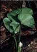
Terrestrial; stem creeping
over soil, 20--100 cm long, leaf scars obscured by cataphylls; internodes short,
1--4 cm long, 2.8 cm diam., usually broader than long, medium green, semiglossy,
coarsely white-streaked at apex; roots more or less smooth, slender, elongate,
2--4 mm diam., few per node, descending; cataphylls moderately coriaceous, 16--22
cm long, sharply 2-ribbed, green to pale green or reddish or pinkish, drying
brown to tan, persisting semi-intact or as fibers at lower nodes, acuminate
at apex.
LEAVES arching to pendent; petioles 25.5--73 cm long, 10--12 mm diam.,
D-shaped, spreading, pale to medium green to reddish at base, with a medial
rib adaxially, rounded abaxially, with adaxial margins erect, surface finely
and weakly striate; sheathing 3.5--5.5 cm long; geniculum slightly thicker than
petiole when apparent, 1.4--1.7 cm long, paler than petiole; blades broadly
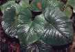
ovate-cordate, subcoriaceous, moderately bicolorous, acute to abruptly acuminate
at apex (the acumen apiculate and downturned), cordate at base, 20--50 cm long,
15.5--36 cm wide (0.9--1.7 times longer than wide), (0.5--0.9 times the petiole
length), broadest at or near the middle, margins broadly undulate, upper surface
dark green, semiglossy to glossy, sometimes matte or subvelvety, drying brown
to greenish brown, lower surface semiglossy, moderately paler, drying brown
to greenish brown; anterior lobe 16--37 cm long, 15--38 cm wide (1.8--3.7 times
longer than posterior lobes), broadest slightly above or at point of petiole
attachment; posterior lobes 5.5--15.5 cm long, 7.4-18.6 cm wide, directed downward,
usually held up somewhat at an angle from the midrib, rounded to obtuse; sinus
parabolic to hippocrepiform, sometimes closed with lobes overlapping before
being pressed; midrib concolorous, flat at base, becoming weakly sunken toward
apex above, thicker than broad at base, becoming convexly raised, concolorous
below; basal veins 8--10 per side, 1(2) free to base, several remaining coalesced
0.5--2(4) cm, prominently sunken above, convexly raised below; posterior rib
usually not naked, sometimes briefly so at base; primary lateral veins (8-10)11--17
per side, departing midrib at a 20--30E angle, spreading to 50--70E angle, more
or less straight to the margins, quilted-sunken and concolorous above, prominently
convex, matte, and darker than surface below; interprimary veins about as conspicuous
as primary lateral veins above, flat and darker than surface below; minor veins
arising from both the midrib and primary lateral veins; tertiary veins distinct,
weakly raised above, darker than surface below.
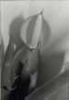
INFLORESCENCES erect, 2--4 per axil; peduncle 2.5--14 cm long, 5--8 mm diam., terete, green to reddish, white-lineate; spathe 6.6--11.8 cm long (0.6--2.5 times longer than peduncle), constricted more or less midway; spathe blade lanceolate, pinkish red, tinged green, pale green to white or green, short white lineate outside, 4--6 cm long, (opening broadly elliptic in face view, pinkish red to white, pale greenish white or pale green inside; spathe tube oblong-ellipsoid, dark reddish maroon to reddish purple to green, weakly short dark lineate outside, 2.5--4 cm long, 1.4--3.8 cm diam., pale green to greenish white to pinkish red inside; spadix sessile or very short stipitate; tapered, 6.6--11.8 cm long, broadest near the base; pistillate portion white, yellowish white (post-anthesis), slightly tapered toward the apex and base, (1.6)2--2.7 mm long, 9--11 mm diam. at apex, 1--1.5 cm diam. at middle, (6)10--11 mm wide at base; staminate portion 3.5--7.1 cm long; fertile staminate portion white, cylindrical to tapered, 7--10 mm diam. throughout, 1--1.5 cm diam. at base, 7--10 mm diam. at middle, 4--6 mm diam. ca. 1 cm from apex, narrower than the pistillate portion, as broad as the sterile portion; sterile staminate portion about as the pistillate portion, white, 1--1.5 cm diam.; pistils 1.8--2.3 mm long, 1.1--1.5 mm diam.; ovary (4)5--6-locular, 1.3--1.5 mm diam., locules 1--1.5 mm long, 0.4--0.6 mm diam., with axile placentation; ovules (7-10)16--22 per locule, 2-seriate, 0.2--0.4 mm long, longer than funicle, style similar to style type B; style apex more or less concave, sometimes weakly lobed; stigma subdiscoid, brushlike, lobed or unlobed, 0.9--1.4 mm diam., 0.2--0.5 mm high, covering center of style apex, depressed medially; the androecium truncate, margins irregularly 3--6-sided; thecae oblong, 0.2--0.3 mm wide; sterile staminate flowers blunt, margins irregularly elongate, 13--18 mm long, 9--13 mm wide. Berries creamy white, obovoid, apex truncate; seeds 20 per locule, 1.9 mm long, 0.2 mm diam., with prominent striations running from funicle to apex and slightly spiraling, perpendicular to larger veins. JUVENILE blades narrowly elliptic to ovate, acute to weakly cordate at base.
Flowering in Philodendron grandipes probably occurs throughout most of the year (February through November, except October) but primarily in July and August. Post-anthesis collections have also been made from throughout the year, and immature fruiting collections are known from throughout the year (except February, March, and June).
Philodendron grandipes ranges from Nicaragua (Zelaya) to Panama, Colombia, and Ecuador (Esmeraldas), from near sea level to mostly less than 750 m (sometimes to 1200 m) elevation in Tropical moist forest, Premontane wet forest and Tropical wet forest life zones.
Philodendron grandipes is a member of P. sect. Philodendron subsect. Philodendron ser. Fibrosa. This species is characterized by its terrestrial habit, short internodes, persistent cataphyll fibers, broadly ovate-cordate blades, usually green spathes and, especially, by its D-shaped petioles with erect margins and a medial adaxial rib.
Philodendron grandipes is closest to P. jodavisianum, which has a similarly shaped petiole and other general features in common. The latter species differs in being an appressed-climbing hemiepiphyte with ovate-triangular (rather than broadly ovate) blades.
This species frequents stream banks in Central Panama and is one of the few consistently terrestrial Philodendron species in Central America. Habitat in Costa Rica, however, is variable. Philodendron grandipes occurs along stream banks on the Osa Peninsula, but at La Selva (Heredia) this species is widely scattered in the forest understory (M. Grayum, pers. comm.).
Spathe tube color in this species is variable to some extent geographically. For example, on the Atlantic slope of Costa Rica the spathe tube is usually greenish, whereas on the Pacific slope is generally reddish on both surfaces.
 |
 |
 |
 |
Additional specimens examined.
COSTA RICA. Alajuela: 36--37 km NW of San Ramón, 500--515 m, 10E15'N, 84E34'W, Croat 68198 (MO); Río Chiquito, Upala, 800 m, Gómez 18639 (MO, PMA). Heredia: Tirimbina, 230 m, Proctor 32347 (LL); 1 km SE of Tirimbina, 220 m, Lent 2136 (CR, F, MEXU, MO); near Río Bijagual, 2 km E of Tirimbina, 150 m, Maas 1329 (U); Porto Viejo--Río Sucio, 20 m, Croat 35676 (CR, MO); La Selva Field Station, 100 m, Grayum 3028 (DUKE); Folsom et al. 8806 (DUKE); Hammel 9126 (DUKE); Sperry 855 (DUKE); Croat 44254A (MO); 44224 (MO); Cannarella 8806 (DUKE); McDowell 687 (MO); Grayum et al. 1758 (F, MO); Jimenez IV (MO), VII (MO). Limón: Braulio Carrillo--Guápiles, 250--270 m, Croat 78745 (CR, INB); Toro Amarillo, 10 km W of Guápiles, 300 m, Lent 73 (F); Hacienda Tapezco--Hacienda La Suerte, 29 air km W of Tortuguero, 40 m, 10E30'N, 83E47'W, Davidson & Donahue 8741 (MO, RSA); Turrialba--Limón, along Hwy. 32, ca. 11 mi. S of Siquirres, 650 m, Croat 43330 (MO); Río Chirripó--Río Corinto, N of Quebrada El Molinete, 400 m, 10E12'N, 83E54'W, Grayum & Jacobs 3525 (MO); Quebrada Cañabral--Río Barbilla, 200--400 m, 10E02'N, 83E26'W, Grayum et al. 8739 (CR, MBM, MO); Hitoy Cerere Reserve, 140 m, 9E42'N, 83E02'W, Hammel & Grayum 14349 (MO); Parque Nacional Tortuguero Lomas de Sierpe, near Río Sierpe, 100 m, 10E24'N, 83E33'W, Robles et al. 2006 (CR, G, MO); Río Blanco, Río Frío--Limón, W of Guápiles, Quebrada Danta, 360 m, 10E12'N, 83E49'W, Croat 68419 (MO); Río Catarata, 50--100 m, 9E37'N, 82E49'W, Burger & Antonio 10888 (CR, F, MO, PMA, U); Río Colorado, 16 airline km SW of Barra del Colorado, 10--120 m, 10E39'N, 83E40'40"W, Davidse & Herrera 31214 (CR, K, MO); Río Sixaola, ca. 3 mi. NE of Bratsi, 15 m, Croat 43253 (CR, MO); 0.3 mi. E of Bratsi, ca. 35 mi. SE of Limón, 30 m, Croat 43289 (MO); Limón-Shiroles, 6.5 mi. SW of Bribrí, 50 m, Croat 43299 (CR, MO); Pococí, Barra del Colorado, Llanura de Tortuguero Sardinas, 15-20 m, 10E38'38"N, 83E44'10"W, Araya 596 (INB). Puntarenas: Osa Península, Piedras Blancas--Rincón, 3.7 mi. W of Pan-American Highway, 90--105 m, 8E46'N, 83E18'W, Croat 67651 (K, MO); 2.5 mi. SW of Rincón, 8E42'N, 83E29'W, Kennedy 1622 (MO); Croat 76751 (MO); Rincón de Osa, 250--540 m, 8E42'N, 83E31'W, Croat & Grayum 59838 (MO); SW of Rincón de Osa, 40--200 m, 8E42'N, 83E30'W, Grayum et al. 7555 (CR, M, MO); Fila Costeña, 950--1150 m, Grayum 10651 (CR, INB); Cortu--La Unión, near San Miguel, Croat 26519 (MO); Finca Loma Linda, 1 mi. SW of Cañas Gordas, 1150 m, Croat 22262 (MO); Allen 6036 (F, GH); Finca El Edén, km 183, ca. 400 m from Santa Marta, Gómez 22954 (MO); Corcovado National Park, Sirena, 0--200 m, 8E29'N, 83E36'W, Liesner 2903 (MO); 5-25 m, 8E29'N, 83E34'W, Hammel & Kernan 16662 (CR, MO); 150 m, Kernan & Phillips 512 (CR, MO); Rancho Quemado, 250--350 m, Marín 39 (CR, INB, MO); vic. Boscosa, 50 m, Croat & Hannon 79244 (MO); Las Cruces Tropical Botanical Garden, 1200 m, 8E49'N, 82E58'W, Croat 57234 (CR, MO); Río Jaba, Las Cruces, 1200 m, Meerow et al. 2017 (SEL). San José: San Isidro del General--Dominical, SW of San Isidro, 4.8 mi. from Río Pacuare, 1000 m, Croat 35215 (MO); 9 mi. SW of Río Pacuare, 680 m, Croat 35346 (MO); 12 km SW of San Isidro de El General, along CR-223, 900-1000 m, Utley & Utley 4925 (MO); 14.5 km S of San Isidro del General, 500 m, Kress & Gómez 88-2467 (SEL); Zona Protectora La Cangreja, ca. 2 km NNE of Mastatal de Puriscal, 400--540 m, 9E42'N, 84E22'W, Grayum 8644 (MO); Parque Nacional Braulio Carillo, above Río Sucio, 5--600 m, Pennington 11533 (K); 1100 m, 10E24'04"N, 85E03'03"W, Carballo 87 (CR, MO). NICARAGUA. Zelaya: 150--180 m, 11E43'N, 84E18'W, Stevens 4965 (MO); Río Rama, at Salto La Oropendola, 15--25 m, 11E57'N, 84E17'W, Stevens 8960 (MO). PANAMA. Bocas del Toro: Chiriquí Grande--Fortuna, 13.2 mi. W of Chiriquí Grande, 310 m, 8E45'N, 82E10'W, Croat & Grayum 60141 (MO); ca. 10 km SW of Chiriquí Grande, ca. 300 m, 8E52'N, 82E10'W, Thompson 4938 (CM, MO); 3.2 mi. N of Divide, 700 m, 8E45'N, 82E15'W, Croat 60264 (CM, MO); 450 m, 8E45'N, 82E15'W, McPherson 7369 (MO); 3 mi. N of Continental Divide, 650 m, 8E47'N, 82E11'W, Churchill & Churchill 6209 (MO); 6210 (MO); Chiriquí Lagoon, von Wedel 1049 (F, GH, MO). Canal Area: Gamboa, Standley 28401 (US); Frijoles, Standley 27471 (US); Barro Colorado Island, Standley 31361 (US); 40888 (US); Croat 16574 (MO); 12300 (MO, SCZ); 11886 (MO, US); 11194 (MO); 11077 (MO); 9526 (MO); 6512 (MO); 5117 (MO); Schmalzel 849 (MO); Summit Gardens, Croat 11491 (MO). Chiriquí: Chiriquí Grande--Fortuna, 7.7 mi. W of Chiriquí Grande, 80 m, 8E50'N, 82E10'W, Croat & Grayum 60114 (MO); Burica Peninsula, San Bartolo Límite, 12 mi. W of Puerto Armuelles, 400--500 m, Croat 22188 (MO). Coclé: La Junta--Limón, 5 hours walk N of Alto Calvario, 800--1000 m, Folsom 5861 (MO); Coclesito--Llano Grande, 200 m, 8E47'N, 80E28'W, Churchill et al. 4170 (MO); El Valle region, 800--900 m, 8E36'N, 80E07'W, Croat & Zhu 76664 (MO, PMA); 67212 (F, MO); 800 m, 25406 (F, MO); ca. 1000 m, Gentry 5662 (F, MO); Croat 14391 (MO); 860 m, 8E37'N, 80E08'W, Croat & Zhu 76710A (MO); 860--900 m, Croat 37398 (MO, RSA); Cerro Pilón, Duke & Dwyer 13977 (MO). Colón: Portobelo--Nombre de Dios, 6--8 km from Peluca Hydrographic Station, Kennedy & Dressler 3331 (US); Portobelo--Río Cascajal, vic. of Nuevo Tonosí, Croat 33648 (K, MO, US); 6 mi. S of Portobelo, Croat 11401 (MO); Portobelo--Nombre de Dios, 1.2 mi. beyond junction of road to Isla Grande, 9E40'N, 79E35'W, Croat 49795 (MO); Altos de Pacora--Cerro Brewster trail, 700 m, 9E18'N, 79E16'W, de Nevers et al. 6234 (MO); Río Guanche, 0.5--1 km upstream from Puerto Pilón--Portobelo road, 6 km S of Portobelo, 5--30 m, Nee 7153 (MO, US); ca. 3--5 mi. inland, 10--100 m, Croat 26205 (MO); 30--100 m, 79345 (PMA, MO); 1.5 mi. upstream, ca. 10 m, Kennedy & Dressler 1513 (SEL); <100 m, 9E27'N, 79E40'W, Croat & Zhu 76245 (MO); Río Miguel de la Borda, vic. of Guásimo, Croat 9940 (MO). Darién: Cerro Pirre region, vic. Cana gold mine, 500--600 m, Croat 37637 (MO); 480 m, 37957 (MO); 17 km N of El Real, trail from base camp along Río Perisenico, 100 m, 8E01'N, 77E44'W, Croat & Zhu 77177 (MO); Río Cocalito, Whitefoord & Eddy 132 (BM); Río Tuquesa, ca. 2 km by air from Continental Divide, vic. of Tyler Kittredge gold mine, Croat 27191 (MO). Panamá: El Llano--Cartí Road, 9.6 km from Pan-American Highway, 410 m, Mori & Kallunki 1835 (MO, PMA); Km 12.4, 300--400 m, Folsom et al. 6178 (MO, PMA); Km 13.2, 370 m, 9E16'N, 78E57'W, Hoover 1313 (MO); Mile 5--6, 350--375 m, Croat 34802 (MO); vic. of Gorgas Lao Mosquito Control Project Site at km 12, 26058 (MO); Serranía de Majé, S of Ipetí, 500--650 m, Huft et al. 1692 (MO); Serranía de Cañazas, Rancho Chorro, above Tortí Arriba, 400--700 m, Folsom 6748 (MO); Cerro Campana, ca. 1 mi. from Inter-American Highway, ca. 150 m, Croat 35969 (MO, RSA). San Blas: El Llano-Cartí Road, trail along Continental Divide, 400 m, 9E20'N, 78E56'W, McDonagh et al. 323 (BM); SE of Puerto Obaldía, Croat 16762 (MO, US); 14 mi. N of Pan-American Highway, 300 m, 9E15'N, 79EW, Croat 69249 (MO); Miria Ubigandup Island, Digole, 0--20 m, 9E26'N, 78E54'W, Herrera 292 (MO); Río Playón Chico, vic. NEBA DUMMAT, 100--450 m, 9E14.5', 78E15'W, Herrera et al. 1399 (MO, PMA); 1 mi. S of Nusagandi, Mile 9, 350 m, 9E20'N, 79EW, Croat & Zhu 76997 (MO, PMA); Nusagandi, 275--300 m, 9E20'N, 79EW, Croat 76594 (MEXU, MO). Veraguas: Santa Fe region, Cerro Tute, 1050--1150 m, Croat 48907 (MO); Escuela Agrícola Alto Piedra-Calovébora, Río Dos Bocas Valley, N of Santa Fe, 350--400 m, Croat 27398 (MO); 450 m, 27550 (MO); Escuela Agrícola Alto Piedra--Río Dos Bocas, ca. 10 km from the school, 530--620 m, Croat 25903 (MO).