![]()
![]()
![]()
![]()
Philodendron jodavisianum G. S. Bunting,
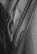
Gentes Herb. 9: 337. 1965. TYPE: Mexico. Chiapas: Cerro de Madrugal,along Teapa--Tacotalpa (Tabasco) Highway, at km 4, W of hwy., on rock face of steep slopes, Bunting 1526 (holotype, US). Figures 243, 245--248, 253.
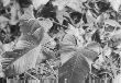
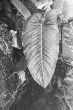
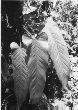
Usually hemiepiphytic, terrestrial; stem appressed-climbing, gray-green to brown or green, sap sweet-scented, drying blackened, leaf scars conspicuous, 2 cm long, 1.7 cm wide; internodes weakly flattened on one side, two-ribbed, weakly glossy, to 8 cm long, but surely longer than wide and 2.5--3 cm diam. at apex, dark to medium green, soon gray, epidermis brown, flaking, fissured sometimes; roots whitish, few per node; cataphylls 10--20 cm long, bluntly or sharply 2-ribbed or unribbed, sharply D-shaped, somewhat spongy, light to medium green or reddish to brownish, sometimes streaked pinkish, semiglossy, drying brown, persisting semi-intact as pale fibers at upper nodes, disorganized below; petioles (18)29--91 cm long, (2)3--7(8-12) mm diam., sometimes terete, usually D- or U-shaped, spongy or firm, dark green, flattened or somewhat sulcate to convex, often with medial rib, margins raised adaxially, rounded abaxially, surface semiglossy, minutely and short-lineate; blades triangular-ovate, more or less subcoriaceous, moderately bicolorous, long acuminate at apex, deeply cordate at base, 25--74 cm long, 18--34 cm wide (1.1--2.8 times longer than wide), (0.5--2 times longer than petiole), broadest more or less near the middle, upper surface dark green, drying blackish, semiglossy, lower surface pale green to yellow-greenish, drying blackish, glossy to semiglossy or matte; anterior lobe 18--58 cm long, 10.1--40.4 cm wide (1.7--4.3 times longer than posterior lobes); posterior lobes 8--17 cm long, (3.7)5--17 cm wide, obtuse to rounded; midrib broadly sunken to broadly convex or flat, dark green, above, raised to narrowly convex, thicker than broad, concolorous or darker than surface below; basal veins 5--10 per side, in part coalesced to 4 cm, barely naked or naked to 2 cm; primary lateral veins 7--11 per side, departing midrib at a 50--60E angle, more or less straight to the margins, obtusely to weakly or narrowly sunken and sometimes weakly quilted above, convex and darker than surface below; interprimary veins almost as prominent as primary lateral veins; minor veins in part discontinuous and darker than surface below, arising from both the midrib and primary lateral veins.
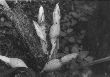
INFLORESCENCES erect, 2--6 per axil; peduncle 3--13 cm long (to 20 cm long in South America), 2--6 mm diam., pale green to whitish, with raised, prominent white striations; spathe semiglossy, 6--14.5 cm long, (0.9--3 times longer than peduncle), sometimes greenish with short white lineations throughout; spathe blade white to pale green (at anthesis), reddish (post-anthesis) (B & K red-purple 7.5/7), short-lineate outside, (opening 4.6 cm long, 3.6 cm wide), very pale green to white, matte, few, sparse, dark-lineate inside; spathe tube semiglossy and greenish to greenish brown or reddish (maroon or reddish at anthesis) outside, green to white inside; spadix weakly exserted from the spathe, 7.6--9.2 cm long, constricted near base of fertile staminate portion; pistillate portion pale green or whitish, cylindrical, 1.4--2.4 cm long, 1 cm diam. at apex, 1.1 cm diam. at middle; staminate portion 5.3--7.6 cm long; fertile staminate portion creamy white, cylindrical to weakly tapered, 0.85--1.5 cm diam. at base, 0.7--1.3 cm diam. at middle, 6--10 mm diam. ca. 1 cm from apex, broadest at the base, narrower than the pistillate portion, narrower than the sterile portion; sterile staminate portion broader than the apical area of the pistillate portion, gray-white, 1.1--1.5 cm diam.; pistils 1.8--2.5 mm long, 1--1.4 mm diam.; ovary 4--6(5-7)-locular; locules 1.3--1.7 mm long, 0.5--0.7 mm diam., with axile placentation; ovules 18--26(23-28) per locule, 2-seriate, 0.2--0.4 mm long, longer than funicle; funicle 0.1--0.2 mm long, adnate to lower part of partition, style 0.2--0.3 mm long, 1--1.4 mm diam., similar to style type B; style apex flat to slightly rounded; stigma subdiscoid, brushlike, unlobed, 1--1.3 mm diam., 0.2--0.6 mm high, covering entire style apex; the androecium truncate, margins 4--6-sided; thecae oblong to obovate, 0.3--0.5 mm wide, more or less parallel to one another, contiguous; sterile staminate flowers blunt, 1.6--1.8 mm long, 1.4--1.5 mm wide. INFRUCTESCENCE with berries white (mature), 6 mm long, 2.6 mm diam.; seeds 14--16(24--28) per locule, 1.3--1.7 mm long, 0.2--0.3 mm diam. JUVENILE plants with internodes 8 cm long, 5 mm diam.; petioles sharply U-shaped in cross-section, usually lacking medial rib adaxially, margins erect.
Flowering in Philodendron jodavisianum occurs in the late dry season and throughout much of the rainy season (April through October) in Panama. In Costa Rica it has been collected in flower in February, and post-anthesis collections have been made in January. Immature fruits have been collected August through November.
Philodendron jodavisianum ranges from southern Mexico to Colombia, Ecuador, and Venezuela (Merida) from near sea level to 1500 m elevation. It occurs in Tropical wet forest and Premontane wet forest in Panama and Costa Rica but also occurs in Tropical moist forest in some parts of Central America.
Philodendron jodavisianum is a member of P. sect. Philodendron subsect. Philodendron ser. Fibrosa. This species is characterized by its short internodes, sharply 2-ribbed cataphylls persisting as pale fibers, petioles flattened or somewhat sulcate above and usually with a medial rib, usually triangular-ovate, blackish-drying blades with many impressed primary lateral veins, and spathes usually greenish on the tube and white on the blade.
Philodendron jodavisianum is quite variable throughout its range and the type (being one of the most northerly collections) differs from most in having more elliptic blades.
Philodendron jodavisianum is most easily confused with P. grandipes, which differs in comprising terrestrial plants with broadly ovate leaf blades. It has also been confused with P. panamense K. Krause which differs in having subterete petioles,promptly deciduous cataphylls, and longer peduncles often bent beneath spathe (see P. panamense for additional details).
Similar collections from South America, especially Croat 57441 from Bahía Solano, Chocó Department, Colombia, differ in sometimes having distinct "cross-veins." Collections from Pichincha Province, Ecuador (Croat 55737 and Grayum & Zamora 9431) differ in having peduncles 16--20 cm long.
Two Darién collections (Hammel et al. 16252 and McPherson 11517) are unusual in having leaf blades with somewhat flaring posterior lobes and markedly concave margins. However, the leaves on the second sheet of the McPherson collection are typically shaped with a convex blade margin.
 |
 |
 |
 |
 |
 |
Additional specimens examined.
BELIZE. Toledo: Blue Creek, Whitefoord 3234 (BM). COSTA RICA. Alajuela: Los Ensayos, Buena Vista de San Carlos, Barquero 10 (UC); Finca Los Ensayos, ca. 11 mi. NW of Zarcero, ca. 850 m, Croat 43583 (MO); Reserva Biológica Monteverde, along Río Peñas Blancas, 820 m, 10E21'N, 84E40'W, Bello & Haber 2881 (INB, MO); Río Zapote, 5 km S of Canalete, along new road to Upala, 100--200 m, 10E48'N, 85E02'W, Burger & Baker 9961 (F, MO, SEL); Cañas--Upala, 4 km NNE of Bijagua, ca. 400 m, Croat 36279 (MO); San Ramón, Bittner & G. Herrera 2134 (CR). Cartago: Moravia--Quebrada Platanillo, Moravia, 3--5 km from Finca Racine, 1200--1300 m, Croat 36648 (MO); along Camino Raiz de Hule, SE of Platanillo, 1200--1400 m, Croat 36756 (MO); Jicotea Valley, Jicotea--Río Pacuare, Croat 36539 (MO). Guanacaste: slopes of Miravalles, above Bijagua, ca. 1500 m, Gómez 19048 (MO). Heredia: 11 km E of Cariblanco, 1060 m, Loiselle 255 (MO); Paracito--Río Claro, Bajo La Hondura, 1100--1400 m, Croat 44516 (MO); Parque Nacional Braulio Carillo, 1000 m, 10E16'38"N, 84E04'57"W, Boyle 1285 (MO); Zona Protectora "La Selva", along trail from main road across Quebrada Cantarrana to Río Guácimo, 300 m, Grayum & Schatz 3216 (DUKE); La Selva Field Station, ca. 100 m, Croat 44300 (MO); 100--150 m, 44320 (MO); Grayum 1915 (MO); Jiménez V (MO); Murrell 1710 (DUKE); Río Frío, W of Finca Zona Nueve, ca. 110 m, 10E18'N, 83E53'W, Grayum 3562 (MO); Río Sucio, near Puerto Viejo, 2 m, Croat 35703 (MO). Limón: Manzanillo de Talamanca, ca. 5 m, 9E38'N, 82E39'W, Grayum & Burton 4340 (MO); ca. 11 mi. S of Siquirres, 650 m, Croat 43329 (MO); Cerro Coronel, 10--40 m, 10E40'N, 83E40'W, Stevens 24346 (MO); Río Sixaola, ca. 0.5 mi. SW of Bambú, ca. 3 mi. NE of Bratsi, ca. 15 m, Croat 43254 (MO). Puntarenas: ca. 1 km S and 2 km W of Cañasas, 60 m, 8E34'N, 83E25'W, Croat & Grayum 59807 (CM, CR, K, MO); Osa Península, 200 m Aguilar 2201 (CR, INB); Golfo Dulce Forest Reserve, Rancho Quemado, 200 m, 8E42'N, 83E33'W, Hammel & Robles 16834 (CR, MO); Piedras Blancas, 3.7 mi. W of Pan-American Highway, 90--105 m, 8E46'N, 83E18'W, Croat 67696 (CR, MO); 67693 (CR, F, MO); Golfito, G. Herrera & Rivera 7042 (CR). San José: above Río Sucio, 5-6000 m, Pennington et al. 11529 (K); San Isidro del General--Dominical, SW of San Isidro, 4.8 mi. from Río Pacuare, 1000 m, Croat 35253 (CR, F, MO); 9 mi. SW of Río Pacuar, 680 m, Croat 35344 (MO); Carara Reserve, SW part of Montañas Jamaica, ca. 2.5 km NE of Bijagual de Turrubares, 460--520 m, 9E45'N, 84E33'30"W, Grayum et al. 5488 (MO); vic. of San Isidro El General, 900 m, Molina et al. 18063 (EAP, F, GH, NY, UC, US); Puriscal, Z.P. La Cangreja, 800 m, Morales 2020 (CR, INB); Tarrazú, vic. Hormiguero, 1100--1200 m, Croat 78962 (INB, MO). GUATEMALA. Alta Verapaz: Tucurú-El Estor, 4--9 mi. up road to Oxec, gravel road N off Hwy 7E, ca. 6 km NE of Panzós, 500--800 m, Croat 41607 (MO); 41698 (K, MO, NY). Izabal: 12 km NW of El Estor, 650 m, Martínez & Stevens 23305 (MO). HONDURAS. Atlántida: Lancetilla Botanical Gardens, 2 mi. WSW of Tela, 10--150 m, Croat 42640 (K, MO); 70--90 m, 15E44'N, 87E27'W, Croat & Hannon 64612 (CM, CR, EAP, G, MEXU, MO); Lancetilla, 100 ft., Yuncker 5008 (F, MICH, MO, NY). MEXICO. Tabasco: Mpio. Teapa, 7 km SE of Teapa on road to Tacotalpa, Rancho San Eneas, 70 m, 17E35'N, 92E50'W, Hammel & Merello 15516 (MO). NICARAGUA. Chontales: 4 km NNW of Cuapa, Cerro Oluma, 700--775 m, 12E18'N, 85E23'30"W, Nee 28413 (MO, NY). Río San Juan: Caño Chontaleño, 20 km NE of El Castillo, 200 m, Neill & Vincelli 3623 (MO); Río Indio, 5 hours upriver from San Juan del Norte, 11E07'N, 83E50--52'W, Riviere 247 (MO). Zelaya: ca. 6 km upriver from Barra de Punta Gorda, 8--10 m, 11E30'N, 83E49'W, Stevens 20756-a (MO); Mpio. Siuna, Santa Rosa, Ortiz 67 (MO). PANAMA. Bocas del Toro: Escudo de Veraguas Island, N coast, 5 m, 9E05'N, 81E35'W, McPherson 11412 (MO, US); Fortuna Dam area, road along Continental Divide, 2.8 mi. S of Continental Divide, 850--950 m, 8E45'N, 82E15'W, McPherson 9676 (MO, US); Chiriquí Grande--Fortuna, 1.2 mi. N of Divide, 5.3 mi. N of bridge over Fortuna Dam, 910 m, 8E44'N, 82E17'W, Croat 60450 (MO, PMA, RSA); along Divide, 1.1 mi. W of highway, 1200 m, 8E44'N, 82E17'W, Croat 60368 (MO); E of camp Corriente Grande (IRHE), 200 m, Correa et al. 3697 (PMA). Chiriquí: Río Chiriquí Valley, vic. of Fortuna Dam, 1100--1200 m, 8E45'N, 82E18'W, Croat 66587 (F, IBE, M, MEXU, MO, US); 1000--1200 m, 8E45'N, 82E15'W, Correa et al. 2686 (MO, PMA); 4.5--5 km N of dam over Fortuna Lake, 1100--1135 m, 8E43'N, 82E17'W, Croat & Grayum 60080 (CM, MO); Gualaca--Fortuna, 10 mi. NW of Los Planes de Hornito, 1260 m, 8E45'N, 82E17'W, Croat 50074 (MO); Gualaca--Chiriquí Grande, Río Hornito, ca. 0.5 km S of Centro de Científicos, 1010--1130 m, 8E44'N, 82E13'30"W, Croat 67922 (MO); 8E45'N, 82E18'W, Croat & Zhu 76376 (MO, SEL); 1100--1200 m, 8E45'N, 82E15'W, Thompson 5026 (CM); Río Chiriquí, beyond Gualaca, 10.8 mi. beyond Los Plantes de Hornito, ca. 1400 m, Croat 48721 (MO). Coclé: Santa Rita Ridge Road, 4--6 km from Transisthmian Highway, 150--200 m, Croat 34280 (MO); Mile 6.5, 370 m, 9E21'15"N, 79E44'W, Croat & Zhu 76960 (MO); El Copé region, near Continental Divide, ca. Mile 1.5, ca. 900 m, Croat 44572 (MO); ca. Mile 5.6, 800 m, Croat 75068 (MO); La Pintada--El Copé, 3000 ft., Hammel 2633 (MO); El Valle region, N of El Valle de Antón, La Mesa, 900--1000 m, 8E40'N, 80E10'W, Hamilton et al. 4111 (INB, MO); 800--900 m, 8E38'N, 80E09'W, Croat 67122 (CAS, CM, COL, HNMN, L, MEXU, MO, PMA); 860--900 m, 37396 (MO); 67211 (AAU, DUKE, MO, NY, PMA, TEX); 67213 (AAU, CM, EAP, MO, PMA, TEX, USCG); 67121 (F, HNMN, MO); 67129 (AAU, CAS, CM, COL, CR, F, HUA, K, L, MEXU, MO, NY, P, PMA, SEL, TEX); 775 m, 8E36'N, 80E07'W, 74793 (KUN, MO); 860 m, 8E37'N, 80E08'W, Croat & Zhu 76742 (MO, SEL); 76710 (MO). Colón: Río Guanche, ca. 3--5 mi. inland, 10--100 m, Croat 26175 (MO). Darién: Cerro Pirre region, Alturas de Nique region, S of El Real, near Cana mine, 650--800 m, 7E45'N, 77E40'W, McPherson 11526 (MO); 11517 (B, MO); Cana gold mine, 480 m, Croat 38003 (MO); 38039 (MO); 600--100 m, Croat 37743 (MO); Parque Nacional Darién, N of Tacarcuna, ca. 18 km E of Pucuro, 600--800 m, 8E05'N, 77E16'W, Hammel et al. 16481 (MO); ca. 17 km E of Pucuro, 850 m, 8E03.5'N, 77E17'W, 16252 (MO). Panamá: El Llano--Cartí road, 10 m from highway, near El Llano, 330 m, Croat 33779 (F, MO, NY); Mile 5--6, 350--375 m, 34771 (F, MO); Mile 6.8, 350 m, 49128 (AAU, CAS, CM, MEXU, MO); Mile 10.1, 325--350 m, 67366 (MO); Río Majé--Quebrada Brava, ca. 60 m, Croat 34657 (F, MO); Cerro Campana, Croat 25252 (MO); 25204 (MO); along trail to summit, 780-875 m, Croat 17207 (F, MO, NY); at end of road beyond Su Lin Hotel, Croat 14227 (MO); 800 m, 8E41'N, 79E56'W, 74772 (CM, MO); summit and upper trail, Witherspoon & Witherspoon 8462 (MO); ca. 1 mi. from highway, 450 m, Croat 35950 (MO, PMA); Cerro Jefe region, Campo Tres, ca. 700 m, Croat 27064 (F, MO); 700--750 m, 9E15'N, 79E25'W, Croat 68687 (IBE, MO, TEX). San Blas: El Llano--Cartí, 23--29 km from Pan-American Highway, 300--400 m, 9E22'N, 78E69'W, Knapp 1839 (MO, PMA); El Llano-Cartí Road, vicinity Nusagandi, 300--350 m, 9E15'N, 79EW, Croat 69279 (DUKE, MO); 300 m, 9E20'N, 79EW, Croat & Zhu 76542 (MO); 350 m, 9E20'N, 79EW, Croat & Zhu 77011 (MO); 450 m, 9E18'N, 79E59'W, Croat 75121 (MO). Veraguas: Río Concepción--Río Barrera, 300--600 ft., Hammel 5252 (MO); Santa Fe region, Alto Piedra--Calovébora, 0.5 mi. N of Escuela Alto Piedra, Parque Nacional Cerro Tute, 800--1,030 m, Croat & Zhu 76914 (MO); 5--8 km from school, 730--770 m, Croat 25967 (MO); Río Primero Brazo, 5 mi. NW of Santa Fe, 700--1200 m, Croat 23114 (MO); 15.6 km NW of Santa Fe, 450--550 m, Croat 27639 (MO); 0.6 mi. beyond Escuela Agrícola Alto Piedra, 730 m, Croat & Folsom 33997A (MO); 34062 (MO); ca. 1200 m, 8E32'N, 81E07'W, Hamilton et al. 1280 (MO); Escuela Agrícola Alto Piedra, Mori & Kallunki 2529 (MO); Santa Fe--Río San Luis, past Escuela Agrícola Alto Piedra, Río Segundo Brazo, 480 m, 8E33'N, 81E08'W, Croat 66901 (CM, MO).