![]()
![]()
![]()
Philodendron tripartitum (Jacq.) Schott,
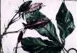
Wiener Z. Kunst 1829: 780. 1829. Arum tripartitum Jacq., Pl. hort. schoenbr. 2: 33, t. 190. 1797. Caladium tripartitum (Jacq.) Willd., Sp. pl. 4: 491. 1805. TYPE: t. 190 in Jacq., Pl. hort. schoenbr. 1797 (holotype). Figures 411--412, 416--424.
Philodendron fenzlii Engl. in Mart., Fl. Bras. 3(2): 144. 1878. TYPE: Mexico. (Holotype, B?; lost). Schott ic. 2599 [neotype, W; here designated].
Philodendron affine Hemsl., Diagn. Pl. Nov. Mexic. 37. 1879. TYPE: Guatemala, Barranca Honda, Volcán de Fuego, Salvin s. n. (holotype, K).
Philodendron tripartitum var. tricuspidatum Engl. in Mart., Fl. Bras. 3(2): 144. 1878. TYPE: Costa Rica, San José, 1300 m, May 1857, C. Hoffmann s.n. (B?, non vidi).
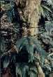
Hemiepiphytic; appressed-climbing,
stem often several meters long, sap watery, very aromatic-scented; internodes
moderately elongate except near the apex, semiglossy, drying coarsely and irregularly
ribbed (the ribs usually acute), 3--14 cm long, 1--2 cm diam. (to 3.5 cm diam.
in Colombia), green to dark green to gray-green, soon drying light brown, epidermis
sometimes loose and papery, roots usually 3--6 per node, usually less than 20
cm long, drying brown, less than 3 mm diam., semiglossy, sparsely scaly; cataphylls
thin, (10)18--33 cm long, usually unribbed, sometimes sharply 1-ribbed, greenish,
sometimes tinged reddish, deciduous intact.
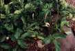
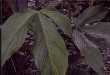
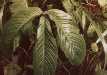
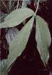
LEAVES erect-spreading to spreading; petioles 20--61 cm long, 6--15
mm diam., terete to subterete, moderately spongy, sometimes obtusely somewhat
flattened, sometimes with an obtuse medial rib, dark green, surface glossy to
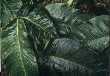
weakly glossy; blades deeply 3-lobed almost to the base or rarely trisect,
ca. as broad as long in outline, thinly coriaceous, semiglossy, moderately bicolorous,
acuminate at apex, lower surface sometimes heavily tinged purplish or reddish;
typically rather dissimilar, median segment usually oblanceolate, sometimes
nearly elliptic, rarely oblong to linear, 15--45 cm long, (4.5)7--14(19) cm
wide, 1.9--7.8 times longer than wide (averaging 4.3 times longer than wide),
(0.9)1.5(1.7) times longer than lateral segments;) the lateral segments conspicuously
inequilateral, arcuate-spreading toward apex, (12)18--35 cm long, 1.3--15 cm
wide, the inner margin always much narrower than the outer margin and weakly
confluent with medial lobe, usually to 1 cm., rarely to 2 cm, the outer margin
1.5--5 times wider than the inner margin where the difference is most severe;
midrib broadly convex, concolorous above, convex to round-raised, darker below;
basal veins lacking; primary lateral veins (4)6--10(12) per side, departing
midrib to a 25E angle on narrow blades or to 90E angle on broader blades, weakly
curved on narrow blades or markedly curved on broader blades to the margins,
sunken and usually concolorous above, convex and darker than surface below;
minor veins fine and conspicuously visible, arising from both the midrib and
primary lateral veins.
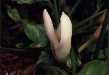
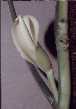
INFLORESCENCES usually solitary, sometimes 2--3 per axil; peduncle 3--16 cm long, 6--13 cm diam., medium green, moderately recurved with reddish ring around the apex; spathe (8)13--21 cm long, 1.2--4 cm diam., weakly constricted above the tube, to 2.5 cm diam. at constriction, usually medium green to yellow-green, rarely creamy white, with dark purple dots (most to 3 mm circumference) heavily so on tube, less so on blade throughout, white to creamy white or greenish white within, cucullate at apex, convolute in lower 2/3 of tube at base, margins whitish or colorless, recurled at anthesis; spathe blade glossy, smooth outside, (the opening 7.5--8.5 cm long, 3.4--5.2 cm wide), creamy white, glossy; resin canals intermittent, orange, appearing medially and extending into spathe tube inside; spathe tube oblong, glossy outside, 5 cm long, 3 cm diam., maroon, deep red, or purplish-violet inside; spadix sessile or shortly stipitate (to 2 mm); clavate, more or less erect, 12.3 cm long, broadest above the middle, weakly constricted between sterile and fertile portions; pistillate portion greenish white to pale yellowish green, 2.5--4.5(6.2) cm long, 1--1.8 cm diam. throughout; staminate portion 7.5--8.5 cm long; fertile staminate portion creamy white, 1.2 cm diam. at base, 1.3 cm diam. at middle, 1 cm diam. ca. 1 cm from apex, broadest in the middle, usually narrower than the pistillate and sterile portions; sterile staminate portion usually broader than the pistillate portion, creamy white, drying yellowish, 1.3 mm diam.; pistils 1.7--2.5(3.4) mm long, 0.6--1.1(2.3) mm diam.; ovary 6--8(10)-locular, 0.8--2.3 mm long, 1.1--2.3 mm diam., with sub-basal placentation; locules 0.8--1.1(2.3) mm long, 0.2--0.4(0.7) mm diam.; ovule sac 0.7--0.9(1.2) mm long; ovules 1--2 per locule, contained within a translucent and gelatinous matrix, 0.4--0.6 mm long, longer than funicle; funicle 0.2--0.4 mm long, (can be pulled free to base), style 0.4--0.8 mm long, 1--1.4(2.5) mm diam., usually similar to style type D (rarely B or E); style apex more or less rounded; stigma subdiscoid, truncate, 0.7 mm diam., 0.2--0.3 mm high, covering center of style apex, inserted on style boss; the androecium truncate, prismatic, margins usually irregularly 5-sided, 1.4 mm long, 2.2 mm diam. at apex; thecae oblong, 0.5 mm wide, more or less parallel to one another; sterile staminate flowers blunt, prismatic, irregularly 4--6-sided, 1.9 mm long, 1.5-2 mm wide. Berries whitish, irregularly angular, 4 mm long, 2--2.7 mm diam.; seeds usually 6--8 per berry, cylindrical, 1.5 mm long, sticky. JUVENILE plants with blades maroon below.
Flowering in Philodendron tripartitum occurs throughout the dry season and the first half of the rainy season (mostly May through July), with seemingly little phenological variation throughout its range. Most flowering collections have been made from January through July with a few from August and also November. Post-anthesis inflorescences have been collected throughout the whole year with the greatest concentration from May to July. Immature fruits are known from January, April, July, August, September, and November, while mature fruits are known only from October.
Philodendron tripartitum ranges from Mexico to Ecuador from near sea level to 1300(1500) m elevation. In Central America, this species ranges along the Caribbean slope in Mexico (Veracruz to Tabasco) and throughout Middle America but occurs on both slopes in Costa Rica and Panama thence along the Pacific slope into lowland Antioquia and Chocó Departments, Colombia. In Mexico, Philodendron tripartitum occurs in Selva Alta Perennifolia and the transition forest to Bosque Caducifolia. In Costa Rica and Panama, it occurs in Tropical moist forest to Premontane wet forest, Tropical wet forest and Premontane rain forest. In Colombia, it is known from Tropical wet forest and Tropical rain forest.
Philodendron tripartitum is a member of P. sect. Tritomophyllum. This species is characterized by its elongate internodes, deeply trilobate leaf blades only weakly confluent at the base or sometimes completely trisect, and spathes scarcely constricted above the tube.
Philodendron tripartitum is most likely confused with the common P. anisotomum. See under the latter species for the differences. It is probably most closely related to P. cotobrusense from Costa Rica which differs in having elliptic medial lobes with 18 or more pairs of primary lateral veins. Philodendron tripartitum may be confused also with P. madronoense from Panama. That species also differs in having elliptic medial lobes with about 25 pair of primary lateral veins.
Along with P. sagittifolium, P. tripartitum is one of the most highly variable and widespread species in the genus, with complex patterns of variation in the shape of the lobes, the degree to which the lobes are confluent, the number of primary lateral veins, and the size and number of inflorescences per axil. Clinal variations range both north and south throughout Mexico and Central America and also elevationally. Most Mexican specimens have the lobes conspicuously confluent at the base with the lateral lobes moderately to prominently auriculate, and all have one inflorescence per axil. This form is well characterized by Engler's drawings of Araceae Drawing no. 48 of the synonym, P. fenzlii. In Mexico, P. tripartitum ranges from sea level to usually about 900 m elevation.
To the south and east in Central America, especially at lower elevations, the blades of P. tripartitum dry paler green and are more weakly confluent at the base or completely trisect with the lateral lobes only weakly auriculate. This form is encountered in eastern Chiapas and Tabasco and ranges through Belize and the remainder of Caribbean coastal Central America, as well as on the Pacific coast of El Salvador. It reaches its most
deeply trisect and pale green expression in Tropical Moist forest along the Caribbean Coast of Panama, but also at lower elevations along the Pacific slope in Darién Province. In contrast to material from Mexico and Belize, this form of the species generally has but a single inflorescence per axil, though in Panama it may have from one to three inflorescences per axil. Noteworthy collections of this form are Dressler 1513 and Breedlove 10330 from eastern Chiapas, which have blades drying pale yellow-green and are weakly confluent with only weakly auriculate lateral lobes, yet occur at between 950 and 1266 m (3800 ft.) elevation.
Most collections of P. tripartitum from above 500 m and from wet life zones (e.g., Premontane wet forest and Tropical wet forest) in Nicaragua, Costa Rica, and western Panama (Chiriquí Province) have typically dark-drying blades with moderately confluent and auriculate lateral lobes. Collections from the highlands of Nicaragua and Costa Rica may have one to three inflorescences per axil, and each inflorescence is typically smaller than when but a single inflorescence is present.
Collections from lowland southwestern Costa Rica on the Pacific Coast differ from those of lowland Pacific coastal Panama and El Salvador in having the lobes more broadly confluent, more prominently auriculate lateral lobes, broader medial lobes, with more numerous primary lateral veins, and in often drying more yellowish brown. Particularly noteworthy is Davidse 24202 from the Costa Rican highlands southeast of Las Alturas. It has comparably broadly convolute lateral lobes, and approaches P. cotobrusense in having medial lobes with closer, more numerous primary lateral veins and 5 inflorescences per axil. It is conceivably a hybrid with that species.
Collections from central Panama, especially El Valle and the vicinity of Cerro Jefe, exhibit extreme variation in leaf morphology and even spathe coloration. This is true to a lesser extent elsewhere in Panama, at Santa Fe, along the El Llano--Cartí Road, and on the Santa Rita Ridge Road. In Coclé, typical plants have somewhat blackened leaf blades with slender, weakly auriculate and weakly confluent lobes. These collections have the medial lobe ranging from 4.4--7.2 times longer than wide. This same narrow-lobed variation occurs also on Cerro Jefe and the Santa Rita Ridge Road where the lobes may be proportionately even more slender, ranging from 7.3--13 times longer than wide. Two collections from the El Llano--Cartí Road, Thompson 4704 and Miller et al. 862, have somewhat larger blades with the medial lobes five to six times longer than wide. These narrow-leaved forms vary from having 1--2 relatively large inflorescences per axil (Luteyn 4066) or with up to three smaller inflorescences per axil (Gentry 7433). The spathes are variously reported as reddish green or red-brown, to pink, red, or purple in color.
Spathe color is not variable throughout most of Central America, where the spathe tube is generally green outside but maroon in the lower two-thirds within. Spathe color becomes more variable in Panama, wherein the narrow-lobed forms (mentioned above) may be reported as purplish or red. As one approaches South America, spathe color becomes more variable. In eastern Panama at the Serranía de Majé and in Darién Province, the spathe is reported as green mottled purple (Whitefoord & Eddy 223) or yellow-green with purple flecks (Churchill & de Nevers 4480), or even cream with red spots (Knapp & Mallet 3160). There seems to be no correlation with either elevation or the degree to which the lobes are confluent or auriculate.
Style type in P. tripartitum is also variable. Throughout most of its range, from Mexico to Panama along the Caribbean coast, the style is raised and button-shaped (Mayo style type D). Generally, the stylar canals emerge onto the surface near the outer margin of the style through moderately large pores on a generally flattened apex. However, some collections, notably Grayum et al. 5034 from 600 m in Heredia Province in Costa Rica, have pores somewhat pie-shaped and the general level of the apex somewhat sunken. More extreme manifestations of this phenomenon are present in Grayum 6979 (studied in reconstituted condition), from Heredia Province at 700-900 m and Croat & Porter 16241, from Bocas del Toro Province, Panama, near sea level. In these collections the style type might more appropriately be referred to as a Mayo style type E since it is definitely funnel-shaped with a distinct marginal rim. In Grayum 6979 the style is broadly bowl-shaped with moderately large pores situated about midway between the annulus and the center. In Croat & Porter 16241 the funnel is held above the surface of the style in dried condition, with the margins curled under and there are radial ribs on the inside of the funnel just as there are in the Grayum et al. 5034 collection. It is also similar to the latter collection and the remainder of the type D styles in having large pores positioned along the outer edge of the nearly straight-walled funnel. Indicating that these style types are probably merely variations of the D-type style is the fact that Gómez et al. 21988 from the highlands of Puntarenas Province has both extremes of style types represented on both of the above mentioned collections.
Three other style types are also present in P. tripartitum and may ultimately allow separation of distinct subspecies because they occur in more isolated populations. One of these is Mayo style type E, represented by specimens collected from the Pacific slope of Costa Rica, e.g., Croat 35248 from San Isidro--Dominical Road at 1000 m, and Burger & Stolze 5473 from Rincón de Osa. In this type of style the stylar pores are smaller than in type D and are arranged in a smaller circle at the base of the funnel. Similar to the material from southwestern Costa Rica in this respect is a collection from Darién Province, Panama, near the Colombian border (Whitefoord & Eddy 223).
The second novel type of style is present on collections from higher elevations in Panama, e.g., Croat 66228 from Chiriquí Province and Croat 69721 from Darién Province. This style type is perhaps sufficiently different to warrant the recognition of these collections as a distinct subspecies. It is similar to Mayo style type B, except that the style is weakly sunken rather than flattened. The stigmatic papillae may cover the entire concave area or they may arise primarily from the center. The stylar pores are smaller than in the style type D, and are arranged in a tight circle at the center of the funnel, much as in the case of style type E in southwestern Costa Rica. In this case, however, there is no sign of a protruded funnel, so apparent on collections from the latter area.
While the style types mentioned here seem to warrant recognition in P. tripartitum of two or more subspecies, the highly variable general morphology of the species and the general state of preservation of the ovaries of most collections precludes the thorough analysis needed.
Standley & Steyermark (1958a) reported the fruits of P. tripartitum as red, but this is unsubstantiated. Bunting (1965) stated that the locules are strictly 1-ovulate, whereas Standley & Steyermark (1958a) described them as 1--3-ovulate. Bunting's findings have here been confirmed.
Many of the variations discussed above, if considered in isolation, are very distinctive and would appear to be worthy of recognition. However, considering the immense variation within populations, the overlapping characteristics and the generally similar structure of the flowers, it seems best to consider this group a single but highly variable species.
This species was reported in his original description for Venezuela (Jacquin, 1797), but it does not occur there. Since the type illustration (t. 190) clearly represents this species it must be presumed that Jacquin, who apparently described the plant from a cultivated collection, must have been confused about the origin of the material. Schott (1829), who transferred Arum tripartitum to Philodendron, claimed to have seen only living material, perhaps the same collection seen by Jacquin at Schönbrunn. Bunting (1979) excluded P. tripartitum from his treatment of the Araceae for Venezuela and used the name P. holtonianum Schott for a Venezuelan species with three-lobed species. The Jacquin plate (t. 190) clearly does not match P. holtonianum, which differs in having the lateral lobes more broadly confluent and not at all auriculate at the base with the posterior rib naked 3 to 5 cm at the base. In contrast, leaves of P. tripartitum are often noticeably auriculate with the posterior rib not at all naked. Krause (1913) treated P. holtonianum as a variety of P. tripartitum but these species, while superficially similar in blade shape, are probably not clearly related.
Caladium trifoliatum Desf. was questionably included by Krause as a synonym of this species, but the description is of a plant with the lateral lobes petiolulate whereas leaf blades in P. tripartitum are at most, trisect, with the lateral lobes sessile.
 |
 |
 |
 |
 |
 |
 |
 |
 |
 |
 |
Additional specimens examined.
BELIZE. Cayo: Lundell 6336 (CM, MICH); McCaw River--Cuevas, vic. of Milonario, 1900 ft., Croat 23670 (MO). Stann Creek: Middlesex, Gentle 2936 (CM, MICH). Toledo: Edwards Road beyond Columbia, Gentle 6217 (LL); Jacinto Creek, Gentle 6002 (LL); Monkey River, Monkey River--Cockscomb, Gentle 4458 (LL, MICH); Punta Gorda, 1 mi. E of junction with road to San Antonio, 100 ft., Croat 24509 (MO); SW Maya Mountains, Columbia River Forest Reserve, trail between Union and Gloria Camps, 700--750 m, 16E23'22"N, 89E08'10"W, Holst 4388 (MO); Southern Maya Mountains, Bladen Nature Reserve, 260 m, 16E30'15"N, 88E55'07"W, Davidse 35794 (BRH, MO). COSTA RICA. Alajuela: 22 km NE of Quesada by air, 4 km W of Muelle San Carlos, 10E28'N, 84E30'W, Liesner 14121 (B, CR, MO); Río Peñas Blancas, below Monteverde Cloud Forest Nature Reserve, 1250--1350 m, 9E17'N, 84E86'W, Burger et al. 10770 (CHAPA, NY); 850 m, Bello 362 (CR, MO); 700--900 m, Haber & Zuchowski 9468 (CR, MO); San Ramon, 820 m, 10E19'N, 84E43'W, Bello & Eyol 2684 (INB, MO); 840 m, Bello et al. 10870 (CR, INB); 15 km N of Boca Arenal, ca. 100 m, 10E38'N, 84E31'W, Liesner et al. 15043 (CR, MO); Cañas--Upala, 13.8 km N of Bijagua, 100--150 m, Croat 36447 (MO); 4 km NNE of Bijagua, ca. 400 m, 36253 (MO); Upala, 550 m, Garcia 187 (CR, INB); Finca Los Ensayos, ca. 11 mi. NW of Zarcero, Croat 43593 (MO). Cartago: Turrialba, Cook & Doyle 378 (US); Moravia--Quebrada Platanillo (Tsipirí), ca. 1250 m, Croat 36659 (MO); 4 km SE of Pejibaye along Río Gato, 700 m, 9E48'N, 83E42'W, Liesner 14342 (CR, MO). Guanacaste: Volcán Miravalles, ca. 800 m, 10E42'N, 85E07'W, Burger & Gentry 9127 (CR, F, U); Parque Nacional Rincón de la Vieja, Volcán Santa María, 900--1200 m, 10E47'N 85E18'W, Davidse et al. 23313 (CR, MO); 840 m, Rivera 479 (CR, MO). Heredia: La Selva Field Station, 100 m, Grayum 3019 (DUKE); 3033 (DUKE); 2444 (DUKE); 100 m, 2863 (DUKE); Croat 44227 (MO); Grayum & Sperry 2212 (DUKE); Sperry 982 (DUKE); Folsom 10011 (DUKE); Quebrada Tigre--Río Sardinal, ca. 9 km SW of Las Horquetas, ca. 600 m, 10E17'N, 84E02'W, Grayum et al. 5034 (MO); Volcán Barva, 700--950 m, 10E17'30"N, 84E04'30"W, Grayum 6979 (MBM, MO, W); Route 9, 3 km S of La Virgen de Sarapiquí, 200 m, Woodruff 188 (FLAS); 9 km SE of San Ramón, 1000 m, 10E16'N, 84E05'W, Loiselle 161 (MO); San Ramón, Tonduz 17719A (K, P). Limón: ca. 4--5 airline km S of Islas Buena Vista in the Río Colorado, 100--180 m, 10E38'40"N, 83E41'W, Davidse & Herrera 31293 (CR, MO); Hitoy Cerere reserve, SW of Valle La Estrella, 150--550 m, 9E39'N, 83E02'W, Grayum et al. 5809 (MO); 2 km W of Río Toro Amarillo, W of Guápiles, 275 m, 10E13'N, 83E50'W, Thompson & Rawlins 1217 (CM); Hone Creek--Cahuita, Gómez et al. 20523 (MO); ca. 1 km N of Shiroles, ca. 50 m, Croat 43277 (MO); ca. 10 mi. S of Punta Cahuita, ca. 3 mi. S of turnoff to Bribrí, ca. 70 m, Croat 43202 (MO); vic. Laguna Pereira, 2--4 m, 10E47--49'N, 83E37'W, Stevens et al. 25184 (MO); Guápiles, 850 ft., J. D. Smith 4981 (US); 30 m, Robles 2241 (CR, MO); Los Angeles, San Miguel, 1100 m, 10E06'40"N, 83E59'40"W, Herrera & Schik 3826 (CR, INB, MO); Parque Nacional Tortuguero, 40 m, 10E28'N, 83E34'W, Robles 1738 (CR, MO). Puntarenas: Cordillera de Talamanca, 2160 m, 9E20'20"N, 83E13'55"W, Bittner 1787 (INB, MO); Parque Nacional Corcovado Estación Sirena, sea level, 8E28'N, 83E35'W, Knapp 2189 (F, MO, NY, US); 1--50 m, Kernan & Phillips 1090 (CR, MO); 220 m, 8E34'N, 83E31'W, Aguilar 2848 (CR, INB); Rincón de Osa, 20--150 m, Liesner 1991 (MO, US); Fila El Tigre, SE of Las Alturas, 1350--1450 m, 8E56'N, 82E51'W, Davidse 24202 (B, MO); Río Canasta, 9.5 airline km NW of Agua Caliente, between Cerro Frantzius and Cerro Pittier, 1500--1600 m, 9E02'N, 82E59'W, Davidse et al. 28422 (CR, MO); Osa Península, Rancho Quemado, ca. 15 km W of Rincón, 200 m, 8E40'N, 83E34'W, Hammel et al. 16981 (CR, MO); Chacarita--Rincón de Osa, 10 km W of Chacarita, ca. 100 m, 8E45'N, 83E18'W, Croat & Grayum 59881 (MO); Osa, Agua Buena, 60--70 m, 8E41'32"N, 83E30'21"W, Ramírez 223 (CR, MO); vic. Rincón de Osa, 50--200 m, 8E42'N, 83E31'W, Burger & Gentry 8922 (F); 20--60 m, Utley & Utley 1234 (F, MO); 30 m, 8E42'N, 83E31'W, Burger & Stolze 5473 (CR, F, US); Quebrada Vaquedano, 500 m, 8E38'45"N, 83E35'25"W, Herrera 4013 (CR, MO); La Tigra--Las Mellizas, 1280 m, Gómez et al. 21988 (MO); Palmar Norte, trail to Jalisco, 50--700 m, Croat 35193 (MO); 6 km S of San Vito de Java, ca. 5000 ft., Raven 21852 (CR, DH, DS); Río Bella Vista near Las Alturas, 1300 m, 8E56'N, 82E51'W, Lent 2686 (CR, F); Finca Las Alturas, at Cotón, Río Cotón, ca. 1300 m, Croat 44362 (MO); La Unión--Cotón, Río Negro--Río Coto Brus, Croat 26582 (MO); Finca Loma Linda, 1 mi. SW of Cañas Gordas, 1150 m, Croat 22295 (MO); Burica Peninsula, Quebrada Palito, 20--270 m, Croat 22617 (MO). San José: El General Valley, vic. of San Isidro El General, 730 m, Molina et al. 18308 (EAP, F, NY, US); San Isidro del General--Dominical, above Alfombra, 1000 m, 9E18'N, 83E46'W, Burger & Baker 10113 (F); 990--1100 m, Croat & Hannon 79108 (INB, MO); 2 km N of Dominical along CR-223, 40--100 m, Utley & Utley 4944 (DUKE); ca. 4.5 mi. SW of Canaán road from Rivas, ca. 900 m, Croat 43438 (MO), 43446 (MO); 9 mi. SW of Río Pacuar, 680 m, Croat 35342 (MO); SW of San Isidro, 4.8 mi. from Río Pacuare, 1000 m, Croat 35248 (MO). EL SALVADOR. Jardín Botánico, Zona 23SC, 800 m, 13E40'N, 89E15'W, Villacorta 317 (LAGU, MO). GUATEMALA. Alta Verapaz: near Finca Sepacuite, Cook & Griggs 743 (US); Chamá, Johnson 404 (CM, US); Cubilqüitz, 350 m, Tuerckheim 8023 (US); J. D. Smith 8023 (US); Pantín, below Tamahú, 600 m, Standley 70543 (F); 4 mi. up road to Oxec, N off Highway 7E, ca. 6 km NE of Panzós, 500 m, Croat 41610 (MO); 9 mi. up road to Oxec, 800 m, 41684 (MO). Izabal: near Entre Ríos, 18 m, Standley 72745 (F). Petén: Dolores, km 83, Machaquila Road, Contreras 2115 (LL). HONDURAS. Atlántida: Lancetilla Reserve, near Tela, 70--150 m, 15E44'N, 87E27'W, Croat 42670 (MO); Croat & Hannon 64640 (MO, NY); Standley 53381 (F, US); S of San Alejo near Río San Alejo, 150--270 m, Standley 7962 (F); ca. 10 km SW of La Ceiba, 80--150 m, 15E42'N, 86E51'W, Liesner 26077 (MO). Gracias a Díos: Ahuas Bila, 200 km SW of Puerto Lempira, 100 m, Nelson & Cruz 9181 (MO, UNAH); Río Plátano, 84E40--85'N, 15E30--55'W, Clewell & Cruz 4062 (CHAPA, MO, UC). Morazán: vic. El Zamorano, 800 m, Molina 34354 (MO). Yoro: Texíguat River, 1 km SW of San José de Texíguat, 100--400 m, 15E30'N, 87E26'W, Hazlett & Brant 8047 (MO); Río Guán Guán, ca. 3 km S of San José de Texíguat, 380 m, 15E30'N, 87E27'W, Evans 1323 (MO). MEXICO. Chiapas: 27--43 km SW of Palenque, 210--810 m, Croat 40335 (MO), 40306 (MO); 460 m, Croat 40269 (MO); 20 mi. N of Ocozocoautla, 700 m, Croat 40634 (MO, NY); 13 mi. N of Ocozocoautla, 900 m, Croat 40620 (MO, NY); Mpio. Cintalapa, Oaxaca--Chiapas border, 4 km W of La Ciénega, 38 km W of Las Cruces, 1400 m, Breedlove 25132 (MO); 5 km W of Bonampak, 350 m, Martínez 6972 (MO); 2 km NE of Bonampak above Cojolite, 350 m, 7939 (MO); Laguna Ocotal Grande, 45 km E of Ocosingo, Dressler 1513 (GH, US); 10 mi. N of Ocozocoautla, 3800 ft., Breedlove 10330 (F); km 18 on road to Malpasco (N of Ocozocautla), 2700 ft., Kennedy 1426 (SEL); Bochil--Pichucalco, 17.1 km SW of Pichucalco, 430 m, Croat 78662 (CHIP, MO). Oaxaca: Uxpanapa region, 17 km E of Sarabia, 100 m, 17E10'N, 94E45'W, Croat & Hannon 63212 (B, BM, K, MO, NY, US); 150 m, 17E33'N, 92E59'W, 65367 (MO); Tuxtepec--Oxaca, 6 mi. W of Valle Nacional on Highway 175, 660 m, Croat 39741 (MO); 8 km SW of Valle Nacional, 400 m, Hernández & Chacón 491 (INB, MO). Tabasco: Grutas de Ocona near Teapa, 20--100 m, Davidse et al. 29509 (CM, MO); Teapa, cultivated, Croat 59160 (MO); Mpio. Tacotalpa, 0.2 km NW of Tapijulapa, Cowan et al. 3496 (CSAT, MO). Veracruz: Valle de Córdova, Bourgeau s.n. (P); Route 185, 4 km NE of Minatitlan, 50 m, King 1113 (MICH); 6 mi. E of Coatzacoalcos, 10 m, Croat 40058 (MO); 7 km NE of Sontecomapan, 0--50 m, 18E33'30"N, 94E59'W, Nee 22607 (F, MO); 5 km NW of Pajapan, Cerro San Martín, 750--900 m, 18E17'20"N, 94E43'W, Nee & Calzada 22697 (F, MO, NY); Los Tuxtlas, 200 m, 18E42'N, 95E10'W, Croat 63163 (MICH, MO, US). NICARAGUA. 40--45 km SW of Waspam, 10--100 ft., Seymour 3776 (MO). Jinotega: Río Bocay, Salto Acatulu, ca. 130 m, 14E13'N, 85E10'W, Stevens et al. 16750 (MO). Matagalpa: Comarca Wanawás, Río Bilampí, 180--200 m, 12E03--02'N, 85E13'W, Araquistain & Moreno 2401 (MO, SAR); Cerro Musún, path to Palán, 300--600 m, Araquistain & Moreno 2471 (AAU, LE, MO); 20 km E of Matagalpa, along Río Yasica, 700 m, Neill 1963 (MO); Cerro Musún, 500--800 m, Araquistain & Moreno 2571 (MO); Cerro Musún, 8 km from village of Wanawás, 500--800 m, 12E59--13EN, 85E14'W, Araquistain & Moreno 2359 (MO); Quebrada Negra, Rio Bilampí, 500 m, Neill 1816 (MO, US). Río San Juan: Bocas de Sábalo, 70--100 m, 11E03'N, 84E27'W, Moreno 26748 (MO); above Río Sábalo, 40 m, 11E03'N, 84E28'W, Moreno & Robleto 26016 (MO). Zelaya: ca. 14.3 km N of El Empalme, Stevens 8303 (BM, MO); El Empalme--Rosita, along new road to Mina Nueva América, Stevens 12667 (MO); 12668 (MO); Pipoly 5293 (MO); 15 km W of Rama, 100 ft., Harmon & Fuentes 5079 (MO); Kuikuinita, S of Siuna, 160 m, Neill 4132 (MO); Río Prinzapolka--Quebrada San Rafael, Waní, ca. 100 m, 13E42'N, 84E50'W, Pipoly 4578 (MO); 4587 (MO); 4588 (MO); 4589 (MO); Waní--Siuna, near Río Matías, ca. 0--100 m, 13E43'N, 84E49'W, Pipoly 4682 (MO); 4701 (MO); Colonia Yolania--Colonia Manantiales (Colonia Somoza), ca. 200--300 m, ca. 11E36--37'N, 84E22'W, Stevens 4825 (MO); Rosita--Puerto Cabezas, ca. 15.7 km SW of Río Kukalaya, <100 m, 13E58'N, 84E12'W, Stevens 8502 (MO); Caño Zamora on Río Rama, ca. 10 m, ca. 11E57'N, 84E16'W, Stevens 8821 (MO); Bonanza--Constancia, 160--360 m, ca. 13E58'--14E01'N, 84E37--40'W, Stevens 12482 (MO); 12455 (MO); El Empalme--Limbaika, ca. 3.9 km SE, ca. 65 m, 13E39'N, 84E24'W, Stevens 12883 (MO); 12886 (MO); vic. of Bonanza, 200--350 m, 14E01'N, 84E35'W, Stevens 13031 (MO); 13053 (MO); 250--350 m, ca. 14E02'N, 84E34--35'W, 18786 (MO); 7.4 m SE, ca. 130 m, 13E38'N, 84E23'W, 21752 (MEXU, MO); 12346 (MO); ca. 140 m, ca. 14E01'N, 84E34'W, Stevens 8056 (BM, MO); 1 km N of "Las Mercedes" settlement, 160--180 m, Vincelli 334A (MO); "Bodega" region, 30 km NE of Río Blanco, 80--100 m, 13E03'N, 84E58'W, Moreno 24078 (MO); "San Agustín," SE of Rama, ca. 60 m, 12E09'N, 84E12'W, Robleto 564 (MO); Neill 3632 (MO); Bonanza--El Salto Grande, Laguna Santa Rosita, ca. 140--160 m, 14E03'N, 84E37'W, Pipoly 3687 (MO); Mpio. Siuna, La Pimienta, Ortiz 1966 (MO); Río Mico, Experimental Station El Recreo, 30 m, 12E10'N, 84E18'W, Davidse et al. 30768 (MO); Río Prinzapolka, ca. 2 km S of Waní, ca. 0--100 m, 13E42'N, 84E50'W, Pipoly 4733 (MO), 4738 (MO), 4747 (MO); Río Punta Gorda, Atlanta, 10 m, 11E34'N, 84E01'W, Moreno & Sandino 12769 (MO); Waspam--Puerto Cabezas, Río Troncera, <200 m, ca. 14E43'N, 84E06'W, Pipoly 4042 (MO); Río Wilike Grande, Wilike region, 100 m, 13E05'N, 84E57'W, Moreno 23999 (MO). PANAMA. Bocas del Toro: Fortuna Dam--Chiriquí Grande, 3.2 mi. N of Continental Divide, 700 m, 8E45'N, 82E15'W, Croat & Grayum 60281 (MO); Changuinola--Almirante, Milla 7.5, Croat & Porter 16241 (MO); Valle del Silencio, Río Changuinola, ca. 1 km above mouth of Río Teribe, <100 m, 9E21'40"N, 82E31'40"W, Croat & Zhu 76431 (MO). Canal Area: Frijoles, 25--30 m, Pittier 3755 (US); Barro Colorado Island, Shattuck 182 (F, GH, MO); Ebinger 99 (MO); Croat 11838 (MO); Schmalzel 797 (MO); Dwyer et al. 8474 (MO); Croat 16535 (MO); 15067 (MO); 11006 (MO); 10741 (MO, UC); 10198 (MO, SCZ); 10085 (MO); 6214 (MO); 6294 (MO); 8605 (MO); 8040 (MO); 6861 (MO); 6495 (MO); 4001 (MO); Summit Garden, Croat 17058 (MO); 10284 (MO, SCZ); 33015 (MO); 10915 (MO). Chiriquí: Volcán--Serrano, 7 mi. N of Volcán, 8E50'N, 82E38'W, Croat 66228 (MO); vic. El Hato del Volcán at Las Lagunas, 3 mi. from Nueva California, 1380 m, 8E46'N, 82E40'W, Croat 67707 (MO, PMA); vic. Santa Clara, 1520 m, Croat 66288 (F, MO); Gualaca--Chiriquí Grande 2.5 mi. beyond Los Planes de Hornito, 1099 m, 8E40'N, 82E13'W, Croat 67739 (CM, MO); 2.8 mi. beyond Los Planes, 1200 m, 48817 (MO); Quebrada La Mina, 2.3 mi. N of Los Planes, 800 m, 8E41'N, 82E13'W, Croat & Zhu 76364 (CM, MO); along Río Colorado, 1200--1400 m, 82E43'W, 8E50'N, Hamilton & Krager 3757 (MO, RSA); vic. Boquete, ca. 1450 m, Croat 26744 (MO). Coclé: La Mesa, N of El Valle de Antón, 800--900 m, 8E38'N, 80E09'W, Croat 67210 (CM, MO); Croat 13358 (MO); ca. 1 mi. N of El Valle, Gentry & Dwyer 3591 (MO); 900 m, Gentry 7433 (F, GH, MO). Coclé--Panamá: trail beyond La Mesa towards Los Llano and the border, Luteyn 3178 (MO); 850--900 m, Luteyn 4066 (MO). Colón: Santa Rita Ridge, 26 km from Transisthmian Highway, 500 m, 9E26'N, 79E57'W, Knapp et al. 1708 (MO); Mile ca. 12, ca. 500 m, 9E25'N, 79E40'W, McPherson 11760 (MO). Darién: Parque Nacional del Darién, ca. 17 km E of Pucuro, Río Pucuro, 750--850 m, 8E03.5'N, 77E17'W, Hammel et al. 16293 (MO); western slopes of Cerro Pirre, 17 km N of El Real, Río Perisenico, 100 m, 8E01'N, 77E40W, Croat & Zhu 77187 (MO); vic. Cana, 500--600 m, Croat 37641 (MO); Alturas de Nique region, 900--1250 m, 7E45'N, 77E40'W, McPherson 11603 (MO); Cerro Sapo, 800 ft., Hammel 1330 (MO); E base of Cerro Sapo along stream (Río Celorio?), 1,300 ft., 1131 (MO); 18 km SE of Jaque, 25 m, Garwood et al. 98 (BM, CM, MO, PMA); N of Punta Guayabo Grande, NW of Ensenada El Guayabo ridges, 0--200 m, 7E24'N, 78E07'W, Knapp & Mallet 3160 (MO, US); Río Coasi, Cerro Coasi, Duke 15554 (US); Río Cocalito, SE of Jacque, 7E18'N, 77E58'W, Whitefoord & Eddy 223 (BM, MEXU, MO). Panamá: Juan Díaz, Standley 30618 (US); Cerro Jefe region, 750--800 m, 9E14'N, 79E22'W, Croat 67082 (F, MO); 67084 (MO); 4.6 km beyond peak on road to Altos de Pacora, ca. 600 m, Croat 35900 (MO); at Altos de Pacora, 750 m, 9E15'N, 79E29'W, Croat & Zhu 76606 (MO); 3--3.5 mi. NE of Altos de Pacora, 700--750 m, 9E15'N, 79E25'W, Croat 68636 (CM, MO); Campo Tres, 5 km NE of Altos de Pacora, Busey 835 (MO); Lago Cerro Azul, 500 m, Sullivan 82 (MO); Cerro Campana, 2500 ft., Hammel 3767 (MO, SEL); Río Majé-Quebrada Brava, 60 m, Croat 34630 (MO); El Llano--Cartí Road, 7--12 km from Interamerican Highway, 360--400 m, Croat 25122 (MO); Km ca. 16--18, 400 m, Tyson & Nee 7355 (MO); El Llano Cartí road, Mile 10.6, ca. 400 m, 9E17'N, 78E58'W, Miller et al. 862 (MO); Mile 6-10, 200--250 m, 9E15--16'N, 78E59'W, Thompson 4704 (CM, MO); Serranía de Majé, along Río Ipetí, near confluence with Río Ambrosio, 100 m, 8E57'N, 79E32'W, Churchill & de Nevers 4480 (MO, PMA, RSA). San Blas: Nusagandi, along El Llano--Carti Road, 11.6 mi. N of highway, 450 m, 9E18'N, 79E59'W, Croat 75135 (CM, MO, PMA). Veraguas: Santa Fe--Río San Luis, vic. Río Tercero Brazo, 700 m, 8E33'N, 81E08'W, Croat 66925 (MO, PMA); Río Dos Bocas, ca. 5--8 km N of Alto Piedra, 730--770 m, Croat 25915 (MO); ca. 500 m, Croat 34242 (MO); vic. Escuela Agrícola--Calovébora, ca. 1200 m, 81E07'W, 8E32'N, Hamilton et al. 1279 (MO).