![]()
![]()
![]()
Philodendron warszewiczii K. Koch & Bouché,
in A. Braun et al., Append. gen. sp. Hort. berol. 1855: 4. 1855--1856. TYPE: Guatemala. San José and Florida, Warscewicz s.n. (holotype, B?; lost?). Guatemala. Santa Rosa: Volcán Jumaytepeque, 6000 ft., Hyde & Lux 4282 (neotype, K; here designated). Figures 16, 441--444, 446--449.
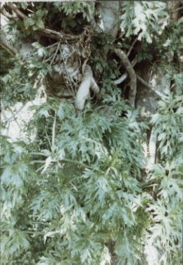
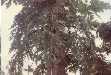
Usually terrestrial,
or on rocks, sometimes epiphytic; stem appressed-climbing, thick, succulent,
bare, leaf scars conspicuous, 1.5--2.6 cm long, 1.5--2 cm wide; internodes short
near apex, semiglossy, glaucous, 3--5(15) cm long, 2.5--7(10)cm diam., often
longer than broad lower down, dark green to gray-brown; roots pale green to
dark brown, few per node, epidermis drying yellowish; cataphylls thin, soft,
18--33 cm long, weakly to sharply 2-ribbed, pale green to whitish, lightly and
densely short-lineate, deciduous intact.
LEAVES often deciduous in dry season; petioles 33-58(80) cm long,
1--2 cm diam., subterete to C-shaped, moderately soft, weakly flattened to rounded
with thick, medial rib adaxially, with adaxial margins sharply raised, surface
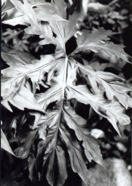
sharply striate, with a dark green ring around apex; blades triangular-sagittate
in outline, deeply bipinnately or bipinnatisect to within 1--4 cm of the midrib,
thin, semiglossy, moderately bicolorous, more or less rounded at apex (the acumen
2 mm long), cordate at base, 31--78 cm long, 30--62 cm wide (0.9--1.3 times
longer than wide), (1--1.3 times longer than petiole), upper surface moderately
glossy, moderately paler, margins sinuate; median lobe 17--52 cm long, 23--63
cm wide, rounded to obtuse; lateral segments 1--30 cm long, 11--28 cm wide,
pinnately lobed with 3 or more lobes per side, acute or acuminate; interlobal
sinuses 0.78--0.94 the length of the blades; midrib flat, obscurely striate,
slightly paler than surface above, raised, obscurely striate, slightly paler
than surface below; basal veins 2--6 per side, with 0--1 free to base, second
and third pair coalesced 2--5 cm, third and higher order veins coalesced 5--7
cm; posterior rib naked along most of its margin; primary lateral veins 3--6
per side, departing midrib at a 55--70E angle, straight to the margins, weakly
raised above, raised, paler than surface below; tertiary veins raised, paler
than surface above and below; minor veins visible, darker than surface below,
distinctly visible on drying, arising from both the midrib and primary lateral
veins. INFLORESCENCES 1(3) per axil; peduncle (2.5--3)4.5--11(16) cm
long, 1--2 cm diam., dark green, dark short-lineate; spathe 13.5--30
cm long, 4--7.5 cm diam. (1.1--3.6(4.7) times longer than peduncle), medium
to dark green throughout, blunt at apex, scarcely constricted; spathe blade
short dark green lineate outside, 12 cm long, pale green to white inside; spathe
tube weakly short dark green lineate outside, 14 cm long, pale green to white
or purple or red inside; spadix sessile; white throughout, 14--24(30)
cm long, constricted weakly above pistillate portion; pistillate portion 3 cm
long in front, 2 cm long in back, 1.3 cm diam. at apex, 1.7 cm diam. at middle,
1.6 cm wide at base; staminate portion 8.3--15 cm long; fertile staminate portion
1.6 cm diam. at base, 1.4 cm diam. at middle, 9 mm diam. ca. 1 cm from apex;
sterile staminate portion 1.3 cm diam.; pistils (1.1)4.1 mm long, 3.5--4.5 mm
diam.; ovary 4-5-locular, 2.6,9.5 mm long, 3.5--4.5 mm diam., with axile placentation;
locules 2.6 mm long, 0.8--1.1 mm diam.; ovule sac 2.4 mm long; ovules 3--4 per
locule, 0.5 mm long, contained in thick, translucent matrix; style 1.2--1.6
mm long, 1.2--1.4 mm diam., similar to style type E; style funnel broad, moderately
deep; style apex more or less flat; stigma subdiscoid, unlobed, 0.7 mm diam.,
0.3 mm high, lining entire upper surface of funnel; the androecium truncate,
prismatic, oblong, margins irregularly 4--6-sided, 3.3 mm long, 1.3 mm diam.
at apex; thecae oblong, 0.4 mm wide, more or less parallel to one another and
nearly contiguous; sterile staminate flowers rounded to somewhat clavate, irregularly
4--6-sided, 2.6 mm long, 1.3--1.8 mm wide. INFRUCTESCENCE brownish outside,
brownish inside, to 3 cm wide pistillate spadix 3--7.5 cm long; berries white,
8--11 mm long; seeds 3--4 per locule, pale yellow, oblong-ellipsoid, 2--2.5
mm long, 1--1.2 mm diam., with pale raphide cells.
Flowering collections of Philodendron warszewiczii are rare, known only from May. Post-anthesis collections, concentrated between April and June (but also January, February, March, July, August, September, and December), imply that the flowering period is relatively broad, perhaps throughout the entire dry season and the first half of the rainy season. Immature fruiting collections are scattered in a somewhat bimodal pattern, one group in the mid-rainy season from July through September, the other group primarily in the early dry season from December through March (especially December and January). The immature fruits collected in November might reflect an early dry season flowering. Mature fruits are known only from this same period between December and Feburary at the beginning of the dry season.
Philodendron warszewiczii ranges from Mexico (Jalisco and Chiapas) to El Salvador on the Pacific slope, and to Honduras and Nicaragua at 300 to 1900 m elevation, in Tropical dry forest life zones. In Mexico, the species occurs in "Selva Mediana Subperennifolia" and "Selva Baja Caducifolia".
Philodendron warszewiczii is a member of P. sect. Polytomium. This species is distinguished by its moderately thin, deeply dissected, bipinnatifid leaf blades and thick, succulent stems often leafless during the dry season.
Philodendron warszewiczii is most similar to P. radiatum and P. dressleri. It differs from P. radiatum in having thinner, more highly divided blades and thicker stems. Although both species occur in some of the same forest types in Mexico, P. radiatum always occupies more mesic sites within these zones. In other parts of Central America for which there are Holdridge Life Zone maps, P. radiatum is found mostly in Tropical moist forest or wetter life zones, whereas P. warszewiczii is known from Tropical dry forest areas.
Although Philodendron warszewiczii and P. dressleri occupy equally dry sites, the latter is distinguished by occurring further north in Mexico and in having the leaves divided to no more than halfway to the midrib (versus nearly all the way to the midrib in P. warszewiczii).
This species occurs principally on the Pacific slope except in Nicaragua (one Honduran collection is from the Atlantic slope). This is probably due to the fact that the Continental Divide runs very near the Pacific Ocean in Nicaragua, and because there is a second, generally much higher, more centrally located range of mountains and hills that creates a rain shadow throughout most of the Pacific side of the country. Because of this, P. warszewiczii inhabits many sites in the central part of the country well within the Atlantic watershed.
Common names for this species include: "Guacamayo"; "Cupapayo"; "Mano de Lión"; Copapayo"; "Ocopayo"; and "Papaya de Monte" (Standley & Steyermark, 1958b).
 |
 |
 |
 |
 |
 |
 |
 |
 |
Additional specimens examined.
EL SALVADOR. S of San Salvador, Calderón 876 (GH, US). Ahuachápan: Ahuachapán vicinity, 800--1000 m, Standley 19726 (GH, NY, US). San Salvador: Calderón 416 (GH, NY, US); San Salvador vicinity, 650--850 m, Standley 19624 (NY, US). GUATEMALA. Jalapa: Jalapa--San Pedro Pinula, 1400--1800 m, Standley 77055 (F). Jutiapa: Monjas--El Progreso, above Ovejero, ca. 1400 m, Standley 77660 (F); near Jutiapa, ca. 900 m, 60495 (F); Agua Blanca--Amatillo, 950--990 m, Steyermark 30367 (F); Jutiapa--La Calera, SE of Jutiapa, ca. 850 m, Standley 76087 (F). Santa Rosa: near Cuilapilla, ca. 900 m, Standley 78051 (F). Zacapa: upper reaches of Río Sitio Nuevo, between Santa Rosalía and first waterfall, 1200--1500 m, Steyermark 42281 (F); Río Lima, Sierra de las Minas, Finca Alejandria, 1500--1700 m, Steyermark s.n. (F). HONDURAS. Río de la Orilla, SE of El Zamorano, 900 m, Anderson & Spoehr s.n. (MO). Comayagua: vic. of Comayagua, ca. 600 m, Standley & Chacón 6021 (F). El Paraiso: Danlí--Los Arcos, 740--850 m, Standley 17007 (F); near Yuscarán, 960 m, Standley et al. 1234 (F). Morazán: Tegucigalpa, Guarabuqui, 2600 ft., von Hagen & von Hagen 1272 (F, NY); S. Antonio de Occidente, 850 m, Valerio 3654 (F); Escuela Agrícola Panamericana, 800 m, Croat 34814 (cultivated) (MO); San Antonio de Oriente, 4 mi. N of Zamorano, Croat 42765 (MO, US); Río de la Orilla region, SE of El Zamorano, 900--950 m, Standley 23205 (F), 23213 (F), 23217 (F); near El Zamorano, 800 m, Morton 7119 (US). Olancho: Río Olancho, San Francisco de la Paz--Gualaco, 1--4 mi. NE of San Francisco de la Paz, 690--900 m, 14E57'N, 86E13'W, Croat & Hannon 64186 (B, MO); W of main 8.6 mi. SW of Catacamas, 400 m, 14E45'N, 86EW, Croat & Hannon 64136 (CM, MO). MEXICO. Chiapas: 20--30 mi. SW of El Jocote, on road to Motozintla, 700--900 m, Croat 40714 (MEXU, MO); Tuxtla Gutiérrez--San Fernando, Chacona canyon, 850 m, Breedlove 69987 (CAS); 22 mi. SE of Comitán, Carlson 1953 (F); 6--8 km E of Frontera Comalapa, road to Ciudad Cuauhtémoc, 1000 m, Breedlove 23428 (MO); 10 km E of Mozotintla, 1,110--1,150 m, Garcia et al. 1527 (MEXU, BM); vic. Tuxtla Guttierez, 830 m, Breedlove & Bourell 68505, (CAS); Mpio. Tzimol, 15 km S of Comitán, 1200 m, Breedlove 51028 (CAS). Jalisco: Autlán--Barra de Navidad, at km 291.67, ca. 300 m, Moore & Bunting 8744 (BH); 9 mi. N of road-junction at W end of Bahía de Navidad, 300 m, McVaugh & Koelz 1758 (MICH); Hwy 110, 2 mi. NE of Huizache, ca. 5 m, Stevens & Fairhurst 1823 (US); 15--16 mi. NW of Barra de Navidad, Dressler & Wirth 2671 (UC, US); Chamela Field Station, 100 km S of Puerto Vallarta, 50 m, 19E30'N, 105E03'W, Gentry 63966 (MO); Bullock 1101 (MO); El Tejón, 100 m, 19E30'N, 105E03'W, Gentry 74426 (MO); 10 km E of Las Palmas, 340 m, 20E50'N, 105E02'W, Cochrane et al. 12022 (MO); Reserva Biosfera Sierra de Manantlán, Lagunillas--Juluapan, Cerro Grande, ca. 1400--1500 m, 19E22'N, 103E56'30"W, Iltis et al. 29716 (MO, US); Rancho Cuixmala, Cumbres 1, Arroyo Cajones, 19E27'N, 104E58'30"W, Lott et al. 3268 (MO). Nayarit: Mirador de Aguila, ca. 14 mi. N of Tepic, 450--600 m, Feddema 824 (MICH); 6-7 mi. S of Compostela, 1000 m, McVaugh 18754 (MICH); 2 mi. SE of Las Varas, road to Mazatlán, 60--90 m, McVaugh 15351 (MICH). NICARAGUA. Boaco: Cerro Mombachito, 8.5 km NW of Camoapa, 1059 m, Araquistain & Moreno 931 (MO); Chontales: 3.9 km N of Comalapa, ca. 460 m, ca. 12E18'N, 85E30'W, Stevens & Montiel 17206 (MO); Juigalpa--La Libertad, ca. 17.4 km NE of Río Mayales, 350--400 m, 12E12'N, 85E17'W, Stevens 4023 (MO). Estelí: 10 km S of Estelí, 1000 m, Neill 1186 (MO); km 163 on Hwy. 1, ca. 11.2 km N of entrance to Estelí, ca. 920 m, ca. 13E13'N, 86E23'W, Stevens 11213 (MO); Cerro Cucamonga, 800--850 m, 10E15'N, 86E22'W, Moreno 14120 (MO); Salto de Estanzuela, ca. 5 km S of Estelí, 1000 m, 13E02'N, 86E20'W, Guzmán et al. 1189 (MO); Río La Estanzuela, 6 km al S de Estelí, ca. 1000 m, 13E01'N, 86E21'W, Moreno 9751 (MO). Jinotega: Jinotega--San Rafael, ca. 2 mi. NW of Jinotega, 1000 m, Croat 43020 (MO); Lago de Abanas, 1--2 mi. E of San Rafael de Norte--Jinotega Road, 1000 m, Croat 42970 (MO); ca. 1 mi. SE of Yalí, 850 m, Croat 42891 (MO). Madriz: San Lucas--Hacienda El Volcán, 2 km NE de San Lucas, 800--900 m, 13E25'N, 86E35'W, Araquistain & Moreno 2018 (K, MO); Cerro Volcán de Somoto (Tepesomoto), 900--1300 m, ca. 13E25'N, 86E35'W, Stevens & Grijalva 16389 (MO); Araquistain & Moreno 2046 (MO); ca. 7 mi. S of Ocotal, along Highway 15, 650 m, Croat 42797 (MO). Matagalpa: 5--8 mi. E of Matagalpa, 800--1000 m, Williams et al. 24048 (F); Cerro Apante, 1000--1400 m, Moreno 155 (MO); 1 km SE of Matagalpa, 800 m, Vincelli 297 (MO). Nueva Segovia: Cerro El Achiote, 7 km N of El Jícaro, 700--1000 m, 13E46'N, 86E08'W, Araquistain & Moreno 2316 (MO, NY); Quebrada El Nancital, ca. 6.2 km N of Ocotal, Quebrada El Nancital, 700--760 m, ca. 13E41'N, 86E24'W, Stevens 3040 (BM, MO); 6.5 km de Ocotal, road to Las Manos, ca. 700 m, 13E40'N, 86E29'W, Moreno 14382 (MO); El Jícaro, "Casas Viejas", ca. 600 m, 13E44'N, 86E05'W, Moreno 13504 (MO); El Jícaro, "El Cinchado", ca. 650--700 m, 13E46'N, 86E05'W, Moreno 13589 (MO); El Jícaro, "Río Grande", road to Murra, 460--500 m, 13E43'N, 86EW, Moreno 13670 (MO).