


Anthurium durandii Engl.,
Bot. Jahrb. Syst. 25: 401. 1898. TYPE: Costa Rica. Inter la Division et 1'Alto del Palmital, January 1891, Pittier 3868 (B, hololectotype; BR, CR, iso-lectotypes, designated Croat & Baker, 1979).
Anthurium lillorale Engl., Bot. Jahrb. Sysl. 25: 405. 1898. TYPE: Costa Rica. Marais de Sierpe, March 1892, Pillier 6837 (BR, holotype; CR, isotype).Epiphytic or rarely terrestrial; stems short; internodes sometimes to 3 cm long; roots short, sometimes purplish; cataphylls moderately thin, 5.4-6 cm long acuminate at apex, drying pale brown, weathering to reticulate fibers, ultimately deciduous.
LEAVES erect-spreading; petioles 9-25 cm long, 4-5 mm diam., broadly and sharply sulcate adaxially, rounded abaxially, sparsely, dark glandular-punctate; geniculum 1.5-3 cm long; blades elliptic, coriaceous, short-acuminate at apex, obtuse at base, 10-31 cm long, 4-15 cm wide, broadest near middle; both surfaces matte, dark glandular-punctate, the lower surface paler, the upper surface drying with an alveolate pattern; midrib convexly raised at base above, acute al middle, weakly sunken toward apex, convexly raised below, narrowing toward apex; primary lateral veins 8-15 per side, departing midrib at 45° angle, straight to collective vein, flat to weakly sunken above, raised below, lesser veins obscure; collective vein arising from the base, 9-15 mm from the margin, a secondary collective vein sometimes extending to about the middle of the blade.
INFLORESCENCE spreading, shorter than or equalling leaves; peduncle 12-40 cm long, ca. 3 mm diam.; spathe moderately thin, pale green to pinkish green (B & K Yellow-green 7/7.5), oblong-lanceolate, 4-7 cm long, 1-1.5 cm wide, broadest near the base, abruptly acuminate at apex, acute at base, inserted at ca. 65° angle on peduncle; spadix pale green turning reddish brown, narrowly tapered toward apex, 10-16.5 cm long, 4-9 mm diam. at base, 2-4 mm diam. at apex; flowers 4-lobed, 3-4 mm long, 2.5-3 mm wide, the sides straight in the direction of the principal spiral, sigmoid perpendicular to the spiral; ca. 3 flowers visible in the principal spiral, ca. 5 flowers visible in the alternate spiral; tepals semiglossy, lateral tepals 1.8-2.2 mm wide, the inner margin convex; pistils emergent but not raised, square, green; stigmas scarcely visible, ca. 0.2 mm long, drying black; stamens emerging from the base, laterals first, scarcely exposed, quickly retracting before alternates emerge; pollen white.
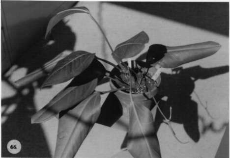
INFRUCTESCENCE with spadix to 22 cm long; berries ovoid, probably orange. Fig. 66.
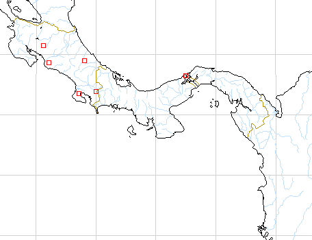
Anthurium durandii is known only from Costa Rica on the Pacific slope in San José and Puntarenas Province at elevations from near sea level to 1,600 m in tropical wet and premontane rain forest. It was initially confused with A. paludosum by Standley, which was reported from the Atlantic slope of Costa Rica. Anthurium durandii resembles A. paludosum superficially but diners in having the cataphyll weathering into a dense fibrous network and in having longer petioles, one third to equally as long as the blade and in having a more or less elliptic leaf blade. It is a member of section Porphyrochitonium. Engler cited two specimens in his original description of A. durandii. The second of these, Tonduz 8422 (BR) is A. gracile (Rudge) Lindl.
 |
Map of Mesoamerican specimens with coordinates
Costa Rica Alajuela: 900 m, 10.19N 84.44W, 9 March 1987, William Haber
& Erick Bello 6936 (MO).
Costa Rica Cartago: 1200 m, 09.48.50N 083.22.40W, 28 July 1995, Herrera,
G. & A. Cascante 8150 (CR).
Costa Rica Cartago: 1200 m, 09.46.05N 083.32.15W, 25 July 1995, Herrera,
G. & A. Cascante 8112 (CR).
Costa Rica Costa Rica:, , Pittier (BR).
Costa Rica Puntarenas: Rincón, 50-450 m m, 8.43N 83.32W, 17
October 1990, Abelardo Chacón 1083 (MO). Costa Rica Puntarenas:
200 m, 08.42N 83.34W, 8 Oct 1984, M. Grayum 4076 (MO).
Costa Rica Puntarenas: 1160-1200 m, 08.47.30N 82.58.00W, 12 September
1985, Michael H. Grayum, Gerardo Herrera & José Berrocal 5975
(MO).
Costa Rica Puntarenas: 1200 m, 8.49N 82.58W, 6-7 March 1984, Thomas
B. Croat 57233 (MO).
Costa Rica Puntarenas: 450 m, 8.41.20N 83.35.40W, 16 June 1990, Herrera
3955 (CR, MO, CR).
Costa Rica Puntarenas: Parque Nacional Corcovado, 1-50 m, 08.28N 83.35W,
26 May 1989, Kernan & Phillips 1115 (CR, MO).
Costa Rica Puntarenas: 600 m, 09.14.00N 83.30.30W, 10 July 1985, Michael
H. Grayum & Barry Hammel 5583 (MO).
Costa Rica Puntarenas: 150-260 m, 8.41N 83.32W, 3 March 1985, T.B.
Croat & M.H. Grayum 59771 (MO).
Costa Rica Puntarenas: 800 m, 10.19N 84.43W, 18 March 1989, William
Haber 9218 (MO).
Costa Rica Puntarenas: Río Riyito, 150 m, 08.41.15N 83.33.50W,
16 July 1990, Herrera 4260 (MO, CR).
Costa Rica Puntarenas: Jimenez, 300 m, 08.29.30N 83.29.10W, 3 Dec 1990,
Herrera 4697 (MO, CR).
Costa Rica Puntarenas:, , Liesner 645 (NY, US).
Costa Rica Puntarenas:, 26-27 Feb. 1973, Liesner 231 (MO, NY, US)
. Costa Rica Puntarenas:, , Luteyn 3855 (DUKE).
Costa Rica Puntarenas: Osa Península,, , Burger & Liesner
7322 (MO).
Costa Rica Puntarenas: Osa Península,, , Liesner 1845 (MO).
Costa Rica Puntarenas: Osa Península,, , Raven 21510 (DS).
Costa Rica Puntarenas:, , Raven 21758 (DS).
Costa Rica Puntarenas:, , Raven 21841 (DS).
Costa Rica Puntarenas: 150-650 m, 08.27N 83.33W - 08.30N 83.38W, 22
May 1988, C. Kernan & P. Phillips 528 (MO).
Costa Rica Puntarenas: 1-50 m, 8.28N 83.35W, 26 June 1989, C. Kernan
1186 (MO).
Costa Rica Puntarenas: 1-20 m, 8.28N 83.35W, 12 September 1989, C.
Kernan 1264 (MO).
Costa Rica Puntarenas: 230 m, 8.41.10N 83.35.00W, 18 February 1992,
Juan Marín 358 (MO).
Costa Rica Puntarenas: 1000-1100 m, 9.04N 83.05W, 30 Mar 1984, Gerrit
Davidse & G. Herrera Ch. 26331 (MO).
Costa Rica Puntarenas: 780 m, 08.59.30N 83.28.00W, 9 December 1988,
Michael Grayum & Gerardo Herrera 9142 (MO).
Costa Rica Puntarenas: 50-150 m, 8.42.20N 83.31.30W, 10 August 1991,
Reinaldo Aguilar 236 (MO).
Costa Rica Puntarenas: 4500 ft, 08.47N 83.00W, , Webster 22090 (F).
Costa Rica Puntarenas: 3600 ft, 08.44N 82.56W, , Webster 21940 (F).
Costa Rica Puntarenas: 160 m, 8.40N 83.34W, 3 May 1988, Barry Hammel
R. Robles & J. Marín 16810 (MO).
Costa Rica Puntarenas: 200 m, 8.40N 83.34W, 3 June 1988, Barry Hammel
G. Herrera, & M.M. Chavarría 16996 (MO).
Costa Rica Puntarenas: P.N. Corcovado; Península de Osa, 200
m, 08.34N 83.31W, 2 September 1993, Reinaldo Aguilar 2205 (CR).
Costa Rica Puntarenas: P.N. Corcovado; Península de Osa, 200
m, 08.34N 83.31W, 6 September 1993, Reinaldo Aguilar 2261 (CR).
Costa Rica Puntarenas: R.F. Golfo Dulce; Península de Osa, 450
m, 08.38.45N 83.35.25W, 24 July 1990, Gerardo Herrera 4033 (CR).
Costa Rica Puntarenas: 10 m, 08.42N 083.29.10W, 29 Aug. 1995, Angulo,
L. 418 (INB).
Costa Rica San José: 500-600 m, 09.45.30N 84.33.00W, 7 August 1985,
Michael H. Grayum, R. Warner, J. C. French & P. Sleeper 5884 (MO).
Costa Rica San José: 320 m, 09.42.00N 84.23.30W, 14 May 1987, Michael
Grayum, G. Herrera, G. Umaña & N. Zamora 8332 (MO).
Costa Rica San José:, , Croat 55203 (MO).
Costa Rica San José: 1300 m, 9.43.38N 84.22.20W, 25 August 1992, J.F.
Morales 495 (MO).
Costa Rica San José: Faja Costeña del Valle de Parrita, 400
m, 09.31N 84.02W, 28 August 1987, Nelson Zamora, I. Chacón &
G. Herrera 1441 (CR).
Costa Rica San José: Fila Bustamante, 1000-1500 m, 09.40.30N 84.11.50W,
28 June 1995, Barry Hammel & J.F. Morales 19889 (CR).
Costa Rica San José: Z.P. La Cangreja; Cerros de Puriscal, 920 m, 09.43.31N
84.23.42W, 20 April 1995, J.F. Morales 3893 (CR).
Costa Rica San José: Fila Bustamante, 900-1000 m, 09.42.57N 84.17.02W,
24 June 1995, J.F. Morales 4479 (CR).
Panama Canal Area: < 25 m, 09.19.00N 79.57.30W, 20 June 1994, Thomas
B. Croat & Guanghua Zhu 76263 (MO).