


Anthurium hacumense Engl.,
Bot. Jahrb. Syst. 25: 363. 1898. TYPE: Costa Rica. Puntare-nas: along banks of Río Hacum (Platanar) near Buenos-Aires, 250 m elev., Tonduz 6536 (B, holotype; BR, CR, isotypes).
Rosulate, epiphyte; stem short; roots few, directed upward; cataphylls coriaceous, ca. 9 cm long, drying dark brown, weathering to coarse linear fibers.
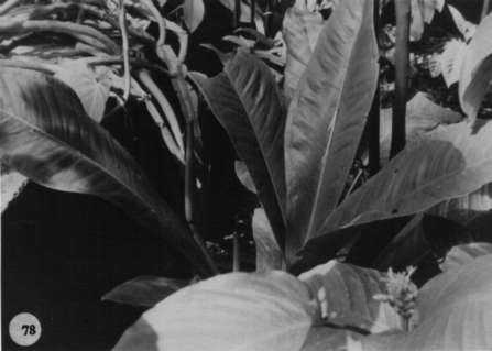
LEAVES ± erect; petioles sulcate, rounded to weakly angular abaxially, 2-12 cm long, 1-1.5 cm diam.; geniculum 2-2.5 cm long;blades narrowly to broadly oblanceolate, coriaceous, 25-81 cm long, 7.5-29 cm wide, acuminate al apex, attenuate al base; upper surface glossy, lower surface semiglossy, conspicuously punctate; midrib broad and flat at base above, soon becoming convexly raised, narrowing and sunken toward apex, acutely raised below; primary lateral veins 7-15 per side, departing midrib at 45° angle, sunken above, raised below, straight to collective vein; collective vein arising from base, sunken above, raised below, 1.5-2 cm from margin.
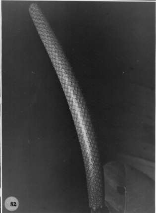
INFLORESCENCE erect-spreading; peduncle 10-27 cm long, subterete; spathe subcoriaceous, yellow-green tinged with violet-purple, oblong-elliptic, 5.5-11 cm long, 2.2-3.5 cm wide, withering and early deciduous; stipe becoming elongate to 29 cm al anthesis; spadix purple-violet (B & K Red-purple 4/2.5), 10-20 cm long, 1-2.5 cm diam. at base, 7-12 mm diam. at apex; flowers sub-rhombic to 4-lobed, 2.4-3.6 mm long, 2-3.5 mm wide, the sides ± straight tojaggedly sigmoid; 9-20 flowers visible in the principal spiral, the alternate spiral irregular with 9-12 flowers visible; tepals glossy, with numerous tiny droplets; pistils flat to weakly emergent, pinkish to dark violet-purple, butterfly-shaped; the stigma oblong-elliptic, ca. 0.4 mm long, having minute droplets for several days before first stamens emerge; stamens emerging in a moderately prompt sequence from middle of spadix to both ends, the lateral stamens preceding alternates by several spirals, the stamens complete at apex before basal flowers complete, emitting a strong, sweet scent at anthesis; anthers dark violet-purple; cxserted on fleshy, pale violet-purple filaments, soon retracting to level of lepals, held in a cluster covering pistils; thecae oblong, slightly divaricate; pollen white or cream turning lavender.
INFRUCTESCENCE with spadix to 23 cm long; berries bright red (B & K Red 6/5), narrowly obovoid, acute to mammilliform at apex, ca. 1 cm long, 4-5 mm wide; seeds 2, white, weakly flattened, 2.5-2.7 mm long, 1.7-2 mm wide, 1-1.5 mm thick. Figs. 78 and 82.
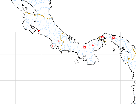
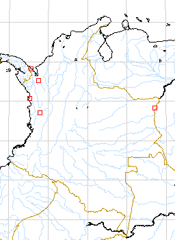
The species is found from Costa Rica, Panama, and probably in Colombia in the Department of Choco, ranging from sea level to 1,560 m and occurring principally in tropical wet forest, but also in premontane wet forest. In Costa Rica the species occurs in San José Province (El General Valley) and Puntarenas Province (Osa Península and the adjacent valley of the Río Diguis). Although the species is restricted to the Pacific slope in Costa Rica, it is known in Panama only from the Atlantic slope and along the Continental Divide on the Pacific slope. Anthurium hacumense is strikingly different from all other species and can easily be distinguished in flower or fruit by its exceptionally long stipe, the dark purplish-violet tepals, and bright red berries. Vegetatively the species can be recognized by the oblanceolate leaves with black punctations on the lower leaf surface and the conspicuous collective vein, (0.8)1-2.4 cm remote from the margin. The species was placed by Engler in section Pachyneurium apparently owing to its large oblanceolate leaves and rosulatc habit, but it should be placed instead in section Porphyrochitonium because of its glandular dotted lower surface and lack of involute leaf vernation. Anthurium hacumense is perhaps most closely related to A. curvilaminum Croat (ined.), which also has short petioles, smaller but similarly coriaceous blades with a prominent collective vein relatively remote from the margin, and a spadix of precisely the same color, which has a pleasant aroma. The latter differs however in having a spadix that is essentially sessile whereas A. hacumense has a spadix which has a stipe equalling or often exceeding the length of the spadix.
 |
 |
Map of Mesoamerican specimens with coordinates
Costa Rica Puntarenas: 100-300 m, 08.41N 83.33W, 8 Oct 1984, Michael
Grayum 4108 (MO).
Costa Rica Puntarenas: 30-40 m, 09.47N 84.37W, 11 January 1985, Michael
Grayum 4715 (MO).
Costa Rica Puntarenas: 150-260 m, 8.41N 83.32W, 3 March 1985, T.B.
Croat & M.H. Grayum 59749 (MO).
Costa Rica Puntarenas: 450-500 m, 08.52.00N 83.17.00W, 22 February
1992, Michael Grayum & Barry Hammel 10122 (MO).
Costa Rica Puntarenas: 0 m, 8.27N 83.33W, 31 January 1988, C. Kernan
24 (MO).
Costa Rica Puntarenas: 1-20 m, 8.28N 83.35W, 3 February 1989, C. Kernan
& Pamela Phillips 937 (MO).
Costa Rica Puntarenas: 50 m, 9.46.10N 84.36.30W, 13 September 1990,
Rodolfo Zúñiga 260 (MO).
Costa Rica Puntarenas: 1100-1200 m, 9.04.30N 83.05.00W, 29 Mar 1984,
Gerrit Davidse & G. Herrera Ch. 26243 (MO).
Costa Rica Puntarenas: 1000-1100 m, 9.04N 83.05W, 30 Mar 1984, Gerrit
Davidse & G. Herrera Ch. 26336 (MO).
Costa Rica Puntarenas: 50-150 m, 8.42.20N 83.31.30W, 21 November 1991,
Reinaldo Aguilar 683 (MO).
Costa Rica Puntarenas: Río Hacum, 250 m,, , Pittier 18 (B).
Costa Rica Puntarenas: 08.30N 83.35W, 19 August 1984, Al Gentry &
Pedro Acevedo 48688 (MO).
Costa Rica Puntarenas: 200 m, 8.43N 83.35W, 28 May 1988, Barry Hammel
G. Herrera, M. M. Chavarría & A. Solís 16872 (MO).
Costa Rica Puntarenas: P.N. Corcovado; Península de Osa, 10
m, 08.28N 83.35W, 26 October 1990, Gilberto Fonseca 2 (CR).
Costa Rica Puntarenas: P.N. Corcovado; Península de Osa, 10
m, 08.28N 83.35W, 30 November 1990, Gilberto Fonseca 45 (CR).
Costa Rica Puntarenas: R.F. Golfo Dulce; Península de Osa, 280
m, 08.26.00N 83.19.20W, 19 September 1990, Gerardo Herrera 4327 (CR).
Costa Rica Puntarenas: 200 m, 08.45.08N 83.18.00W, 10 September 1996,
Thomas B. Croat & Dylan Hannon 79161 .
Costa Rica Puntarenas: 110 m, 08.48.39N 83.16.18W, 10 September 1996,
Thomas B. Croat & Dylan Hannon 79198 (CM (sterile), MO, WU).
Costa Rica Puntarenas: 50 m, 08.42.01N 83.30.48W, 11 September 1996,
Thomas B. Croat & Dylan Hannon 79232 .
Costa Rica Puntarenas: P.N. Corcovado, 200 m, 8.34N 83.31W, 4 June
1994, Aguilar, R. 3329 (INB).
Costa Rica Puntarenas: P.N. Corcovado, 0 m,, 15 May 1995, Chinchilla,
M. 166 (INB).
Costa Rica San José: 320 m, 09.42.00N 84.23.30W, 14 May 1987, Michael
Grayum, G. Herrera, G. Umaña & N. Zamora 8341 (MO).
Costa Rica San José: Cordillera de Talamanca, 700 m, 09.29N 84.01W,
29 August 1987, Nelson Zamora, I. Chacón & G. Herrera 1457 (CR).
Costa Rica San José: Z.P. La Cangreja; Cerros de Puriscal, 500 m, 09.43.10N
84.23.20W, 10 Sep 1992, J.F. Morales 631 (CR).
Costa Rica San José: 550, 9.42.55N 84.13.52W, 28 ENE 1997, Barry Hammel,
Grayum & J. F. Morales 20798 (INB)
Panama :, , Croat 78347 (MO). Panama Cocl: 150 m, 8.46N 80.27W, 11
Sept. 1987, Thomas B. Croat 67471 (MO).
Panama Coln: 500 m, 9.20.4N 79.45.4W, 11 January 1987, Gordon McPherson
10249 (MO).
Panama Coln: 550 m, 9.20N 79.45W, 21 May 1986, Gordon McPherson 9205
(MO).
Panama Darien: Río Cocalito,, 12 Feb. 1982, Whitefoord &
Eddy 181 (BM).
Panama Panamá: 450 m, 09.18N 79.59W, 3 April 1993, Thomas B. Croat
75120 (MO).
Panama Panamá: 350 m, 9.15N 79.00W, 26 Jan. 1986, Gordon McPherson
& M. Merello 8160 (MO).
Panama San Blas: 350 m, 9.20N 79.00W, 13 Feb. 1983, C. Hamilton &
H. Stockwell 2924 (MO).
Panama San Blas: 30 m, 9.24N 79.24W, 10 Feb. 1986, Greg de Nevers &
H. Herrera 7110 (MO).
Panama San Blas: 350 m, 9.19N 78.55W, 13 Oct. 1984, G. de Nevers &
H. Herrera 4005 (MO).
Panama San Blas: 30 m, 9.24N 79.24W, 10 Feb. 1986, Greg de Nevers &
H. Herrera 7122 (MO).
Panama San Blas: 350 m, 9.19N 78.55W, 6 Nov. 1984, Gred de Nevers 4201
(MO).
Panama San Blas: 350 m, 9.19N 78.55W, 11 March 1986, Greg de Nevers,
Heraclio Herrera & Stephanie Kaza 7324 (MO).
Panama Veraguas: 570 m, 08.33N 81.08W, 13 July 1994, Thomas B. Croat
& Guanghua Zhu 76858A (MO).
Map of South American Specimens with coordinates
Colombia : Río Leon, 15 m, 07.37N 076.43W, 21 Sept. 1981, Brand &
Cogollo 136 (COL, JAUM).
Colombia : Mpio. Turbo, 20 m,, 28 Nov. 1983, Brand & Gonzalez 654
(COL, JAUM).
Colombia : 10 - 520 m,, 11 Sept. 1987, Cardenas 434 (JAUM).
Colombia : Mpio. Ríosucio, 100 - 200 m,, 19 May 1988, Cardenas 1965
(JAUM).
Colombia : 10 m,, 28 Mar. 1986, Renteria 4877 (JAUM).
Colombia : Mpio. Turbo, 20 m,, 27 Mar. 1984, Brand & Gonzalez 1022
(JAUM).
Colombia : 80 m,, 7 July 1981, Brand & Cogollo 3907 (JAUM).
Colombia : 80 m,, 21 Sept. 1981, Brand 137 (JAUM).
Colombia : 10 - 520 m,, , Cardenas 446 (JAUM).
Colombia : Region de Uraba, 20 - 100 m,, 14 Oct. 1987, Cardenas 663
(JAUM).
Colombia : Mpio. Ríosucio, 400 - 500 m,, 16 Nov. 1987, Cardenas 870
(JAUM).
Colombia : Mpio. Ríosucio, 30 - 100 m,, 10 Jan. 1988, Cardenas 926
(JAUM).
Colombia : Mpio. Ríosucio, 100 - 400 m,, 19 Jan. 1988, Cardenas 1089
(JAUM).
Colombia : Mpio. Ríosucio, 20 - 300 m,, 27 Mar. 1988, Cardenas 1299
(JAUM).
Colombia : Mpio. Río Sucio,, 27 Mar. 1988, Cardenas 1539 (JAUM).
Colombia : Mpio. Ríosucio, 50 - 520 m,, 20 Apr. 1988, Cardenas 1774
(JAUM).
Colombia Choco: 100 m, 06.15N 77.25W, 7 March 1983, Al Gentry &
Adrian Juncosa 41098 (COL, JAUM, MO).
Colombia Choco: 150 m, 5.32N 67.48W, 18 April 1983, Thomas B. Croat
56106 (COL, JAUM, MO).
Colombia Choco: 200 m, 8.30N 77.20W, 10 Jan. 1983, Adrian Juncosa 602
(JAUM, MO).
Colombia Choco: 30-60 m, 5.12N 76.37W, 5 Nov. 1983, Adrian Juncosa
1273 (JAUM, MO).
Colombia Choco: 30-60 m, 5.12N 76.37W, 5 Nov. 1983, Adrian Juncosa
1274 (JAUM, MO).
Colombia Choco: 605 m,, 4 June 1976, Forero et al. 1851 (COL).
Colombia Choco: Río baudo,, 1967, Fuchs et al. 22033 (COL).
Colombia Choco: 180 m, 08.23N 077.07W, 22 May 1989, Betancur et al.
1182 (HUA).