![]()
![]()
![]()
![]()
Philodendron rothschuhianum (Engl.) Croat & Grayum,
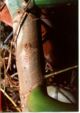
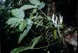
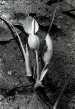
Ann. Missouri Bot. Gard. 74: 659. 1987. Syngonium rothschuhianum Engl., in Engl. & K. Krause, Pflanzenr. IV. 23E (Heft 71): 124. 1920. TYPE: Nicaragua. Matagalpa: Matagalpa, 1000 m, 12E55'N, 85E55'W, Rothschuh 229 (holotype, B). Figures 4, 9, 31, 336--340, 347--348.
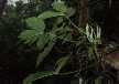
Hemiepiphytic to epiphytic
or rarely terrestrial; stem appressed-climbing, creeping, sap watery, leaf scars
conspicuous, 2 cm long, 2.5 cm wide; internodes short, semiglossy, 1.8--3 cm
long, 1.5--3 cm diam., about as long as broad, gray-green, epidermis fissured;
roots scurfy, few per node; cataphylls fleshy, soft, 16--23 cm long, unribbed
then sharply 2-ribbed at apex, or bluntly 2-ribbed throughout or weakly 1-ribbed
throughout, green, short dark striate, semiglossy, deciduous, emarginate with
subapical apiculum at union of ribs at apex.
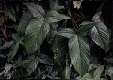
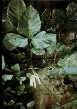
LEAVES erect-spreading to spreading; petioles 33--71 cm long, 3--13(20)
mm diam., subterete, moderately spongy, medium green, obtusely 1-ribbed near
apex adaxially, surface weakly glossy, densely green striate; sheath inconspicuous;
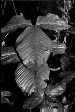
blades deeply 3-lobed, subcoriaceous, weakly bicolorous, gradually acuminate,
long to very long acuminate at apax (the acumen inrolled, 1--2.5 mm long), more
or less hastate at base, 22--42 cm long, 25--57 cm wide (0.6--1 times longer
than wide), (0.5--1 times the petiole length), about two-thirds as long as petiole,
upper surface semiglossy, lower surface weakly glossy, slightly paler; sinus
hippocrepiform; median lobes 16--39.5 cm long, 7--20 cm wide; lateral lobes
narrowly ovate, 14--28 cm long, 5--17 cm wide, directed toward apex, broadly
confluent 2--5 cm with medial lobe, the margins undulate; midrib sunken to narrowly
concave, paler than surface above, almost round-raised, paler than surface below;
basal veins 10--15 per side, the remainder arranged in a more or less regular
manner in the posterior lobe, coalesced in part throughout much of their length
into a central rib; posterior rib usually not naked, sometimes naked for 1 cm,
rarely to 2.5 cm; primary lateral veins 5--12 per side, departing midrib at
a 50--65E angle, narrowly sunken, concolorous above, convex below; interprimary
veins sunken and concolorous above, raised, almost as conspicuous as primary
lateral veins below; minor veins darker than surface below, arising from both
the midrib and primary lateral veins.
INFLORESCENCES erect, 2--3(9) per axil; peduncle 5.2--21 cm long, 5--10 mm diam., medium green, densely lineate; spathe (6.5)8--14(16) cm long, (0.6--2.2 times longer than peduncle), markedly constricted above the tube; spathe blade pale green to greenish white to yellowish green outside, to ca. 5 cm wide when open, ca. 2.4 cm diam. at constriction, greenish white to creamy white inside; spathe tube ellipsoid, 4--7 cm long, pale green to yellowish green outside, greenish to greenish white to creamy white inside; spadix very short stipitate; somewhat protruding forward at anthesis, 10.5 cm long, constricted at base of fertile staminate portion; pistillate portion pale lime-green, 3.7 cm long in front, 2.5 cm long in back, 1--1.3 cm diam. at apex, 1.2--1.4 cm diam. at middle, 1.2 cm wide at base; staminate portion 6.4--9.3 cm long; fertile staminate portion creamy white, clavate, 1 cm diam. at base, 1.3 cm diam. at middle, 1 cm diam. ca. 1 cm from apex, usually broader than the pistillate portion; sterile staminate portion broader than fertile portion or pistillate portion, creamy white, 1.6--1.9 cm diam. at base, 1.3--1.4 cm. diam. at apex; pistils 1.6--2.6 cm long, 1.2 mm diam.; ovary 5--7-locular, 0.8 mm long, 1.1 mm diam., with sub-basal placentation; locules 0.8 mm long, 0.3--0.4 mm diam.; ovule sac 0.6 mm long; ovules 1 per locule, contained within translucent, gelatinous ovule sac, 0.3--0.5 mm long, longer than funicle; funicle 0.1--0.3 mm long, (can be pulled free to base), style 0.6 mm long, 1.2 mm diam., similar to style type B; style apex sloping to rounded; stigma brush-like, hemispheroid, 0.7--1 mm diam., 0.3--0.6 mm high, covering entire style apex; apex drying button-like, with or without radial ridges from center; the androecium truncate, oblong, more or less prismatic, margins irregularly 4--6-sided, 1--1.6 mm long, 1.5--1.9 mm diam. at apex; thecae oblong, 0.4 mm wide, more or less parallel to one another, nearly contiguous; sterile staminate flowers blunt, sometimes clavate or prismatic or irregularly 5--6-sided or 3--6-sided, 1.7--2.3 mm long, 1.6 mm wide. Berries pale green or pale yellow-green to greenish white, 4 mm long, 2.5 mm diam.; seeds 1--3, medium green, (1.2)2.1--2.3 mm long, 0.6--0.8 mm diam., within thin envelope. JUVENILE plants with petioles sheathed to about midway; blades with posterior lobes hastate, acuminate at apex, promptly auriculate on posterior margin, broadly confluent with anterior margin on anterior margin.
Flowering in Philodendron rothschuhianum occurs during the dry season and early rainy season. Most collections have been made in March but, flowering occurs as late as August. Post-anthesis collections have been made from January through November (except October), but are particularly abundant from March through May. Immature fruiting collections have been made from April through September (also December), but mature fruits are known from only August.
Philodendron rothschuhianum ranges from Honduras (Gracias a Dios) and from Nicaragua (Río San Juan, Zelaya, Jinotega and Matagalpa) to Panama (Bocas del Toro, Veraguas, and Coclé), principally on the Atlantic slope, from sea level to 1450 (mostly less than 1,000) m elevation. It occurs in Premontane wet forest, Tropical wet forest, and less frequently in wetter parts of Tropical wet forest and Premontane rain forest life zones.
Philodendron rothschuhianum is a member of P. sect. Tritomophyllum. This species is distinguished by its short internodes, unribbed, deciduous cataphylls, subterete, moderately spongy petioles, and especially by its deeply three-lobed blades about two-thirds as long as the petioles with the lateral lobes broadly confluent with the medial lobe and the sinus hippocrepiform and naked along the posterior rib for a short distance from the petiole.
Philodendron rothschuhianum is most frequently confused with P. tripartitum, which differs in having less auriculate lateral lobes which are scarcely or not at all naked along the posterior rib. In addition, P. tripartitum has a much more slender, scarcely constricted, spathe tube reddish within (versus a markedly inflated, uniformly greenish tube in P. rothschuhianum).
In terms of leaf shape, P. rothschuhianum is closest to P. cotobrusense. The latter differs in medial lobes with 18-19 pairs of primary lateral veins (versus 5-12 pairs for P. rothschuhianum).
The style apex is apparently variable in this species, with Croat 66772 and Neill 1569 having Type B styles while Croat 35657 has style Type D. The latter has the style apex prolonged into a distinct boss separated from the rest of the style apex by a distinct neck.
 |
 |
 |
 |
 |
 |
 |
 |
 |
 |
Additional specimens examined.
COSTA RICA. Alajuela: Quebrada Guillermina, on N side of Volcán Arenal, 500 m, 10E29'N, 84E42'W, Lent et al. 3415 (F, U); Naranjo--Aguas Zarcas, 8 km NE of Quesada, 600 m, Croat 46942 (MO); Finca Los Ensayos, ca. 11 mi. NW of Zarcero, ca. 850 m, Croat 43567 (MO); 43637 (MO); Monteverde Biological Reserve, Río Peñas Blancas, 800 m, Bello 1980 (CR, INB); 850--900 m, 10E20'N, 84E43'W, Haber & Bello 6836 (MO); 850 m, 10E19'N, 84E43'W, Haber & Cruz 8409 (MO); Finca de Tomás Guindon, 900 m, 10E19'N, 84E43'W, Bello 763 (CR, MO); Río Sarapiquí, road to Colonia Virgen del Socorro, ca. 740 m, 10E5.5'N, 84E10.5'W, Grayum & Hammel 5516 (B, CR, MO); ca. 800 m, Burger & Antonio 11101 (CR, F); 11097 (F); 830 m, Croat 68301 (MO); Vara Blanca--Puerto Viejo, 3 mi. N of San Miguel, 380 m, Croat 35657 (CR, MO); Cañas-Upala, 3 km NNE of Bijagua, 450 m, 10E45'N, 85E3'W, Burger & Baker 9881 (CR, F); 8 km N of Bijagua, 300 m, Croat 36502 (CR, MO); 13.8 km N of Bijagua, 100--150 m, Croat 36438 (MO); 36402 (CR, MO); near Río Zapote, 1.8--2.7 km S of Río Canalete, 100 m, Croat 36402 (MO); 13 km W of Fortuna, Río Tabacón, 500--550 m, 10E29'N, 84E43'W, Liesner et al. 15250 (MO); 15 km NW of Arenal by air, 700 m, 10E34.5'N, 84E54'W, Liesner et al. 15088 (MO); 15065 (MO); San Ramón, Bittner & Venschott 1941 (CR); Nilsson 460 (CR). Cartago: 4 km SE of Pejibaye, 700 m, 9E48'N, 83E42'W, Liesner et al. 14330 (MO); Turrialba, León 393 (US). Guanacaste: Parque Nacional Guanacaste Estación Pitilla, 600 m, 11E02'N, 85E25'18"W, Hammel et al. 17372 (CR, MEXU, MO, NY, U, USJ). Heredia: near Tirimbina, E of Río Sarapiquí, 150--250 m, 10E24'N, 84E7'W, Burger & Burger 8026 (F); Tirimbina, 700 ft., Proctor 32148 (LL); La Selva Field Station, 100 m, Jacobs 2826 (DUKE); Folsom 9874 (DUKE); 50--80 m, 10E26'N, 84E01'W, Grayum & Chavarria 8300 (MO); Puerto Viejo de Sarapiquí, Grayum 2120 (DUKE); ca. 100 m, Grayum 2856 (MO); Croat 57199 (MO, voucher of live plant of Grayum 2856); Río Puerto Viejo, ca. 2 km upstream from confluence with Río Sarapiquí, 100 m, 10E26'N, 84E10'W, Burger & Stolze 5756 (CR, US); Volcán Barva, Río Peje--Río Sardinalito, 700--950 m, 10E17.5'N, 84E04.5'W, Grayum 6981 (CR, MO); 700--800 m, 10E17.5'N, 84E04.5'W, 6720 (CR, MO). Limón: ca. 1 mi. NE of Bribrí, ca. 40 mi. SW of Limón, above Río Catarata, 50--100 m, Croat 43245 (MO); 7 km SW of Bribrí, 100--250 m, Gómez et al. 20320 (MO); Río Pacuare, 50--100 m, 10E05'N, 83E29'W, Burger & Liesner 6895 (F, MO); vic. of Guápiles, 300--500 m, Standley 37469 (US); 2 km W of Río Toro Amarillo, W of Guápiles, 275 m, 10E13'N, 83E50'W, Thompson & Rawlins 1216 (CM); Hacienda Tapezco--Hacienda La Suerte, 29 air km W of Tortuguero, 40 m, 10E30'N, 83E47'W, Davidson et al. 7138 (RSA); Bahía de Portete Parque Nacional, 0--10 m, 10EN, 83E05'W, Thompson & Rawlins 1176 (CM); Cerro Coronel, E of Río Zapote, along and above new road, within 1 km of Río Colorado, 10--40 m, 10E40'N, 83E40'W, Stevens 24277 (CR, MO); E of Río Zapote, 10--100 m, 10E40'N, 84E40'W, Stevens 23974 (CR, MO); E of Laguna Danto, 20--170 m, 10E41'N, 83E38'W, Stevens 24453 (CR, MO); Parque Nacional Tortuguero, Puesto Cuatro Esquinas, 4 m, 10E32'N, 83E30'W, Robles 1837 (CR, MO); Barra del Colorado, 0--2 m, 10E47'N, 83E35'W, Stevens 24073 (CR, MO); Río Colorado, Barra del Colorado, 1--5 m, 10E47'40"N, 83E35'30"W, Davidse & Herrera 30869 (MO); 2 airline km SSE of Islas Buena Vista, 10--120 m, 10E40'N, 83E40'W, Davidse & Herrera 31035 (MO); Río Reventazón, Finca Montecristo, below Cairo, ca. 25 m, Standley & Valerio 49027 (US); Parque La Amistad, Fila Tsiurábeta, between Río Urén and Río Lari, 800 m, 9E27'30"N, 83EW, A. Chacón 294 (CR, MO). Puntarenas: hills above Santa Elena, 3 km N of Monteverde, 1450 m, 10E20'N, 84E50'W, Haber & Bello 5067 (MO). San José: S of San José, Greenman & Greenman 5353 (MO); Braulio Carrillo National Park, Fila Carrillo, 700 m, Gómez et al. 21149 (CR, MO); 600--700 m, Croat 78777 (CR, INB). HONDURAS. Gracias a Díos: Ahuas Bila, 200 km SW of Puerto Lempira, 100 m, Nelson & Cruz 9146 (CM, MO, NY, UNAH). NICARAGUA. Chontales: Cerro Buenavista, 5 km N of Cuapa, Neill 637 (MO); 4 km NW of Santo Domingo, 280 m, ca. 12E17'N, 85E06'W, Grijalva et al. 3771 (MO). Jinotega: Finca San Luis, 21 km from Valle del Cuá, NW de El Cedro, 700 m, 13E30'N, 85E38'W, Moreno 959 (MO); Río Bocay, Caño Litutus, ca. 175 m, ca. 13E58'N, 85E21'W, Stevens et al. 16617 (MO); Salto Kayaska, 190--340 m, ca. 13E51'N, 85E22'W, Stevens et al. 16484 (F, MO). Matagalpa: Macizos de Peñas Blancas, SE side, drainage of Quebrada El Quebradón, slopes NW of Hacienda San Sebastián, 800--1100 m, 13E14--15'N, 85E38'W, Stevens 21258 (MO); summit of El Toma Road, Neill 1569 (HNMN, MO); 10.5 km NW of Matagalpa, ca. 1000 m, 12E57'N, 85E51'W, Moreno 10233 (MO); El Paraíso, 10 km de Matagalpa, 800--820 m, 12E59'N, 85E51'W, Moreno 6607 (MO); N of Cerro Musún, near Wanawás, Araquistain & Moreno 2741 (LE, MO); NW of Cerro Musún, near Paylo, 500--800 m, Araquistain & Moreno 2572 (MO); 800--1200 m, 2510 (MO); 2495 (CAS, HNMN, MO); 300-600 m, 2471A (MO); Río Bilampí, NW of Cerro Musún, 4 km SW of Wanawás, 200--500 m, 13E00--01'N, 85E14'W, Araquistain & Moreno 2614 (HNMN, MO, US); Comerca Wanawás, 180--200 m, 12E02--03'N, 85E13'W, Araquistain & Moreno 2398 (HNMN, K, MO); near Cerro Musún, 8 km from Población Wanawás, Palán Grandre, 500--800 m, 12E59'--13EN, 85E14'W, Araquistain & Moreno 2355 (HNMN, MO, NY); Río Bilampí Valley, Cerro Musún, Salto Grande of Quebrada Negra, 500--800 m, Neill 1800 (MO). Río San Juan: Caño Chontaleño, 20 km NE of El Castillo (Río Indio watershed), 200 m, Neill 3367 (MO); Neill & Vincelli 3541 (BM, MO); Río Indio Valley, 6 km upstream from the junction with Caño La Pimienta, 300--600 m, Neill 1557 (MO); Río Sábalo, Buenos Aires, 70 m, 11E02'N, 84E28'W, Moreno 25595 (MO). Zelaya: ca. 1.5 km NE of Las Esperanza de Las Quebradas, 300--350 m, ca. 13E38'N, 85E02'W, Stevens & Moreno 19308 (MO); Limbaika--El Empalme, ca. 3.9 km SE of El Empalme, ca. 65 m, ca. 13E39'N, 84E24'W, Stevens 12930 (MO); road to Mina Nueva América, ca. 10 km from main road, Stevens 12687 (MO); Rosita--Puerto Cabezas, ca. 15.7 km SW of Río Kukalaya, <100 m, ca. 13E58'N, 84E12'W, Stevens 8500 (MO); Cerro El Inocente, near Caño Majagua, ca. 800--1000 m, ca. 13E45'N, 85EW, Stevens 6805 (MO); Siuna--Matagalpa, ca. 31.4 km beyond Río Uli, ca. 8.9 km beyond Rosa Grande La Balsama, <200 m, Stevens 7456 (MO); Cerro Saslaya--San José del Hormiguero, from Loma Mollejones eastward, ca. 200--400 m, ca. 13E44--45'N, 84E57--58'W, Stevens 7049 (BM, MO); Caño Majagua, ca. 750--850 m, ca. 13E45'N, 85E00--01'W, Stevens 6936 (MO); Caño Majagua--Caño Sucio, ca. 600--800 m, ca. 13E45'N, 84E59'--85EW, Stevens 6821 (MO, PMA); vic. of La Pimienta, ca. 13E45'N, 84E59'W, Pipoly 6225 (MO); Cerro La Pimienta--El Hormiguero, ca. 800--1000 m, ca. 13E45'N, 84E59'W, Pipoly 6012 (MO); Cerro La Pimienta, number 1, ca. 900--980 m, ca. 13E45'N, 84E59'W, Pipoly 5129 (MO); ca. 13 km above Kururia, on road to San Jerónimo, <200 m, Pipoly 3794 (MO); Risco de Oro, ca. 40 m, Pipoly 5043 (MO); 10 km NE of Siuna, along Caño Madriguera, 250 m, Neill 3754 (BM, MO); 4 km NE of Siuna, road to El Dos, 300 m, 13E45'N, 84E45'W, Moreno & Robleto 20856 (MO); 1 km W of El Naranjo, 200--210 m, 13E34'N, 85E11'W, Moreno & Robleto 20616 (MO, QCA); SE of Cerro El Hormiguero, ca. 900--1000 m, 13E44'10"N, 84E59'50"W, Grijalva 473 (MO); Río Iyas, Quebrada El Toro, 260--280 m, Vincelli 370 (MO); near San Juan del Norte, C. Smith 5 (F). PANAMA. Bocas del Toro: Gualaca--Chiriquí Grande, ca. 10 km SW of Chiriquí Grande, ca. 300 m, 8E52'N, 82E10'W, Thompson 4936 (CM); 4.2 mi. S of Chiriquí Grande, ca. 0 m, 8E55'N, 82E09'W, Croat 66815 (MO); Fortuna Lake area, Continental Divide, 900 m, 8E48'04"N, 82E15'04"W, McPherson & Aranda 10185 (MO, PMA, W); 3.2 mi. N of Divide, 700 m, 8E45'N, 82E15'W, Croat & Grayum 60276 (CM, MO, RSA); 850--950 m, 8E40'04"N, 79E50'04"W, McPherson 10546 (AAU, M, MEXU, MO, US); ca. 300 m, ca. 8E50'N, 82E15'W, McPherson 8522 (K, MO, US); 6.6 mi. N of bridge over Fortuna Lake, 780 m, 8E45'N, 82E18'W, Croat 66772 (MO); 1.2 mi. N of Divide, 910 m, 8E44'N, 82E17'W, Croat 60462 (MO, PMA); 1.6 mi. N of Divide, 850 m, 8E48'N, 82E13'W, Croat 74931 (MO); 1.6 mi. N of Divide, 770 m, 8E45'N, 82E17'W, Croat & Zhu 76534 (MO); Río Cricamola, Finca St. Louis-Konkintoë, ca. 10--50 m, Woodson et al. 1919 (MO). Coclé: El Copé region, 4.5 mi. N of El Copé, 750 m, 8E38'N, 80E35'W, Thompson 4760 (CM, MO); 5--6 mi. N of El Copé, 600--800 m, 8E38'N, 8E35'W, Croat & Zhu 77224 (CM, MO); 680--770 m, 8E39'N, 80E36'W, Croat 74828 (CM, MO); Alto Calvario, Croat 68848 (MO). Veraguas: 15.6 km NW of Santa Fe, 450--550 m, Croat 27704 (MO); 350--400 m, 27385 (MO).